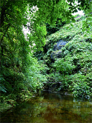
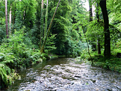
The Lydford Gorge is the most dramatic of a number of temporarily deep and narrow ravines formed by rivers flowing from the edge of the granite uplands of Dartmoor, generally cutting into dark, sedimentary rocks. The gorge is managed by the National Trust, and is situated just inside the western edge of Dartmoor National Park, where the River Lyd, created by the union of several upper tributaries near the village of Lydford, is confined within a dark, tree-lined valley around 2 miles in length, though the river remains fairly enclosed for another 2 miles, outside the park, surrounded by the more extensive woodland of Lydford Forest.
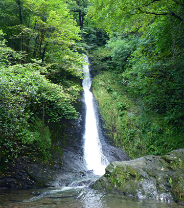
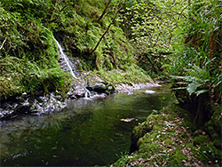
The upper section is reputedly the deepest gorge in southwest England, and contains two notable features. Near the upstream end is a vertical-walled passageway where the dark, moss and fern-covered walls are just a few feet apart, and the river flows through a series of chutes and potholes known as the Devil's Cauldron, while at the lower end of the National Trust land is White Lady Waterfall, the tallest waterfall in south England, formed at the junction with a tributary, the River Burn.
The cauldron and the waterfall may be visited via half mile loop trails starting from parking areas at either end of the gorge, or by a more strenuous, 2.5 mile loop that links the two, one part of which follows the north bank of the river, the other traversing the slopes to the south. The gorge is prone to flooding and this can cause one or more of the paths to be temporarily closed.
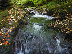
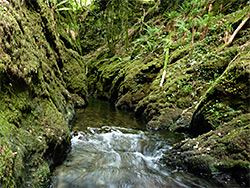
Two other named features are Tucker's Pool, a deep section upstream of the Devil's Cauldron, just below another, completely inaccessible section of narrows, and Tunnel Falls, a second, less dramatic group of interlinked potholes. The high, steep sides and the tall trees restrict other plants to those tolerant of moisture and shade, including ferns, mosses, fungi and liverworts, though the valley does have a small selection of wildflowers.
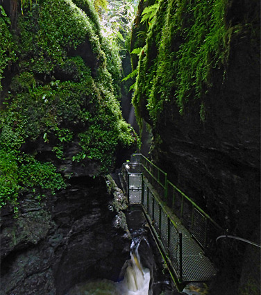
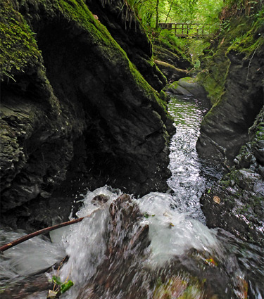
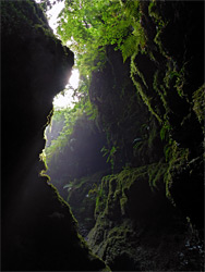
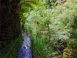
The larger, upper parking area for the gorge is just south of the bridge over the river along the road south of Lydford; other facilities here are a gift/book shop, a cafe, an adventure playground and a picnic area. The path runs south, through a walled garden and into the woods, soon reaching a junction where ahead is the higher section of the full loop, towards White Lady Waterfall (intended to be hiked one way, in this direction) and right is the loop to the Devil's Cauldron. This latter path descends the steep valley sides to the river, crosses on a footbridge and meets the other section of the long loop, at river level. Turning right (north), this path moves across the mouth of a minor tributary, informally named Pixie Glen, and re-crosses the river on another bridge, at the lower end of the most enclosed section of the gorge, where the river flows through a chain of potholes. Cliffs rise up and the path is cut into the sheer rock wall, ascending via steps and protected by railings. All surfaces seem permanently wet, shaded by the tall trees high above, and nearly all non-vertical services are thickly covered with ferns, moss and other green-leaved plants. Undulations on the cliffs above, from ancient potholes, indicate the river has been cutting down through the hard, dark slate layers for a very long time. A short spur path continues into a particularly dark and enclosed section underneath overhanging rocks to the brink of the biggest and deepest pool in the Devil's Cauldron, fed by a waterfall through a narrow chute on the far side.
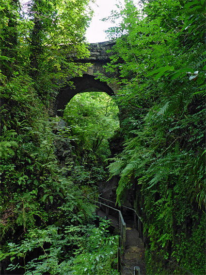
The main path soon climbs to the rim of the gorge and leads back to the car park, while another, less used branch continues upstream, descending slightly back to the river, a hundred feet upstream of the Devil's Cauldron, then proceeding underneath the Lydford road bridge and on beside the river before ending after 0.3 miles at Tucker's Pool, a patch of deep water at the junction with a tributary from the north. Above here, the River Lyd narrows once more, flowing from an impassable, vertical-sided section that seems to extend several hundred feet, the start of which is viewable by scrambling over a low bank at the right edge of the pool, beyond the end of the trail.
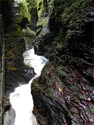
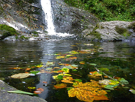
White Lady Waterfall is by far the most popular attraction of the Lydford Gorge, even though the Devil's Cauldron is more unusual. The fall is reached from the lower parking area, also off the road south of Lydford, beside a disused railway line, closed in 1968. The trail goes under the railway and divides; the right branch is the upper section of the long loop from the Devil's Cauldron parking area, and it is worth walking at least a few hundred feet along here - down to the River Burn, across on a bridge and alongside a short distance, coming close to the brink of the waterfall. The other branch of the trail again soon forks, though both routes lead to the fall. The right path is steeper and more direct, while the left is more gentle, traversing the hillside without switchbacks to the river then returning upstream a few hundred feet. Most people ascend one way then return the other. The waterfall, at the lower end of the River Burn, is 90 feet tall and nearly vertical; a continuous whitewater column, widening gradually towards the base. One final junction is with the path upriver (crossing on a suspension bridge), the other part of the long loop, which is the route most likely to be closed if water levels are high. The waterfall has formed as a result of river capture, a process whereby a river erodes downwards much more rapidly than a lesser tributary, resulting in a big drop off at the end of the smaller drainage.
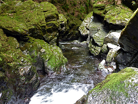
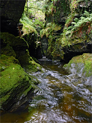
Unlike the north-side path, which runs on top of the wooded slopes, close to fields, the trail on the south side of the River Lyd stays right beside the water, in places cut into cliffs, and passing through a short tunnel at one point. The path starts in the west at a footbridge just below White Lady Falls, and follows the gorge upstream mostly using narrow benches, rising a little way above the river for a few short stretches, all the while giving good views and easy access to various pools, cascades and enclosed channels. The most photogenic feature, Tunnel Falls, is a series of cascades between deep potholes, about half way along the path, which is forced to cross briefly to the south side in order to avoid a sheer cliff. Beyond here are more narrow passageways and mossy cliffs, before another bridge taking the trail to the south, and the steep climb back to the eastern parking area.