Isolated, two mile section of the Jurassic coast backed by tall red cliffs above sand, pebble or rock beaches, extending to large sea stacks. Explorable by walking west from Sidmouth, around low tide
Location
Sidmouth, along the B3176
Walk
1.9 miles, from Sidmouth to the edge of Ladram Bay
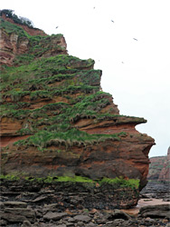
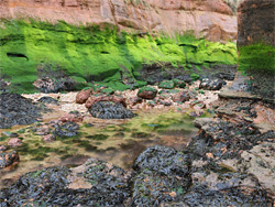
The high, red sandstone and mudstone cliffs that form the majority of the western section of the Jurassic Coast are seen most spectacularly either side of Sidmouth, south Devon, where they rise up to 500 feet above the English Channel, forcing the coastal footpath inland, by up to half a mile in some areas, to avoid steep-sided gullies and unstable slopes. The most extensive stretch is to the east, extending for five miles until the rocks change abruptly to white chalk, near Beer, but perhaps more interesting is the coast to the west. Here the cliffs are high for nearly two miles, and are made more scenic by several large sea stacks and other eroded formations at their base. These offshore rocks are topped with grass and moss and their sides are often covered by bright green seaweed, growths also found at moist places along the shoreline, and this vegetation creates a photogenic contrast with the rich red of the bedrock, resulting in quite a spectacular coastal landscape. All this region is inhabited by numerous noisy seagulls, and there is plenty of sea life in the pools exposed at low tide.
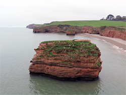
The sea stacks occur over a 1.5 mile stretch, from the far end of the sandy beach west of Sidmouth, westwards to Ladram Bay, a cliff-lined, pebble-filled inlet, location of a holiday camp. A promontory on the east side of the bay prevents access to the main area of sea stacks beyond except for about half an hour around low tide, and there are no routes down from above owing to the cliffs, but the place can be seen relatively easily by walking west from Sidmouth, and is accessible for about half the time - three hours either side of low tide. Some sections are visible from above along the coast path though the central area is not, as the trail moves away, on the far side of a 157 metre summit named High Peak Hill, but in any case the formations are much more impressive when seen from close-up, at beach level. Southwest of Ladram Bay is an only slightly less scenic stretch of red cliffs, extending nearly 3 miles to the River Otter near Budleigh Salterton.
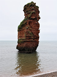
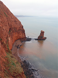
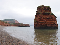
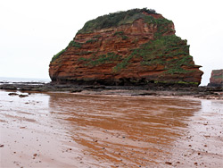
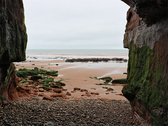
The year-round holiday resort at Ladram Bay is accessed by a short drive east of Otterton. A small amount of (free) parking is available just before the entrance, on verges, though visitors are meant to use a parking area in the resort, charged at a flat rate of £5 per day. From here, a short walk south reaches the narrow beach, formed of large white pebbles of chert and flint beneath low red cliffs of Otter sandstone. The beach is 1,100 feet long and there are two large sea stacks nearby, fully submerged except around low tide; the largest is Ladram Rock, towards the east end. The west end of the beach is perhaps the most scenic area, as here the cliffs turn seawards, becoming a little higher and completely vertical, and are topped by a few small trees, projecting out at angles, above a band of rock pools and terraces. For most of the time the cliffs prevent access further down the coast, around the promontory of Smallstones Point, though the way is clear at the lowest tide. The other prominent sea stack is named George the Third Rock. Views from above are also good; the coast path runs right along the cliff edge beside the bay, and briefly further east, before climbing beside a hedge bordering a field, where viewpoints are more limited, then entering woodland on the slopes of High Peak Hill, and moving away from the shore. At the edge of the trees is a final overlook, high above a narrow beach (Picket Rock Cove), flanked by more sea stacks.
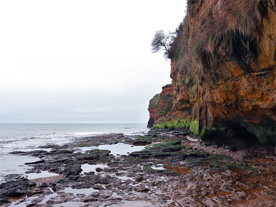
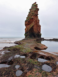
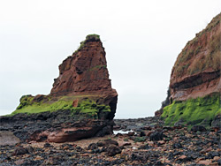
Walking northeastwards at beach level from Ladram Bay near low tide is not recommended owing to the short access window, only around half an hour; instead the main area of sea stacks is best approached from Sidmouth, parking along the western approach to town, the B3176 - free in winter, metered in summer. The long, mostly sandy beach that extends westwards is initially bordered by low, earthen slopes but these become steadily taller, steeper and more vertical, and the first interesting formations are reached after about 0.7 miles - red cliffs, tiny caves, seeps lined by green vegetation, and wave-cut terraces. The sands stop not far beyond, and ahead all the inter-tidal zone is rocky, red or stained black, covered by seaweed or barnacles. The first named formation is Lade Rock, a slender hoodoo close to the edge of the cliffs, that seems to mark the furthest place explored by most visitors, as the terrain becomes just a little more difficult beyond, though still lacks any major obstacles, just patches of slippery boulders and residual pools. A larger stack is named Man of God Rock, and a lower, less distinctive outcrop further seawards is Wheel Rock.
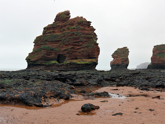
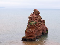
After the minor promontory of Green Point, two larger stacks come into view; Big Picket Rock and Little Picket Rock, this latter always surrounded by water, followed by the tallest part of the cliffs, beside a long stretch of pebbles, leading to the inlet of Sandy Cove. Some of the red strata in this section are inlaid with white, mineralised deposits, forming an array of small-scale patterns. Past the cove is the most scenic part of the coast, with four more sea stacks, plus many rock pools and some narrow terraces. The largest is of the four is Hern Rock Point, while due south is Hern Rock, which contains a short cave. The other two are nameless, since they have formed quite recently, in the last hundred years; one used to be the column supporting Ladram Arch, a large and formerly well-known span somewhat comparable in outline to Durdle Door in Dorset, until its collapse in 1925. The other - close to the cliffs, a short distance north - also supported an arch.