Loop hike along ridges and valleys to several peaks in the Black Mountains, Brecon Beacons National Park, including 810 metre Waun Fach; also visiting waterfalls, a reservoir and a ruined monastery
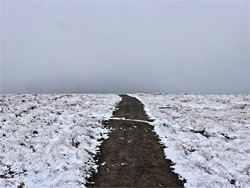
The Black Mountains are the easternmost of the four ranges contained within Brecon Beacons National Park, and all are in Wales (Powys and Monmouthshire), apart from a small section that extends into neighbouring Herefordshire. The main peak is Waun Fach, at 2,661 feet or 810 metres, which although the third highest in the park apart from Pen y Fan and Corn Du (or the fourth if nearby Craig Gwaun Taf is included), is visited much less often than these more famous summits. This is partly since it is harder to reach - the closest trailheads are quite far from major roads and because, like most summits in the Black Mountains, it rises only slightly above the surrounding flat-topped ridge, and hence lacks the expansive vistas of the better defined summits to the west. Also, much of the surrounding land is permanently boggy, as the ridgetops are mostly covered with thick peat deposits, with very few exposed rock formations. But the scenery improves at the edge of the ridge, since here the land slopes sharply down; the best viewpoints are on the west side of the peak, looking across towards the central Beacons.
Waun Fach can be approached from various directions, the closest three access points being Hermitage Bridge in the south, Pengenffordd to the west and the road to Grwyne Fawr Reservoir in the southeast, and as well as there-and-back hikes the peak is often visited as part of a loop, also involving one or more of the neighbouring ridges, such as the route described below. This starts at Capel-y-ffin, near the upper end of the Vale of Ewyas, first visiting the interesting remains of a Victorian monastery, proceeding over the ridge to the west, down the far side to the adjacent valley of Grwyne Fawr, and up the opposite slope to Waun Fach. Next is a northwards walk to a slightly lower summit (Pen y Manllwyn) followed by a easterly traverse along the north edge of the Black Mountains, overlooking the Wye Valley; over the minor high points of Rhos Dirion and Rhiw y Fan to the upper end of the valley of Nant Bwch, which is followed back to the start at Capel-y-ffin, after a short diversion to a hidden waterfall. The round trip distance is 12 miles, with a cumulative 2,000 feet of elevation gain.
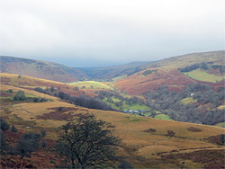
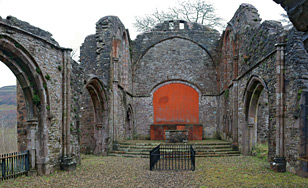
The village of Capel-y-ffin is 14 miles north of Abergavenny and 3.5 miles from Llanthony Priory, in the narrow Vale of Ewyas, at a junction, where a short, dead-end road leads a little way up the valley of Nant Bwch, a tributary of the main river, the Honddu; the through-road continues northwards to Gospel Pass and then Hay-on-Wye. Around the junction are some verges suitable for parking, though the path starts a quarter of a mile further, along a side road to the Grange Pony Trekking Centre, where vehicles may be parked for a daily fee of £3. The track to the centre forks; the path starts at the end of the right branch, while the other leads to a house and also the remains of a monastery, very aged in appearance though constructed relatively recently, in 1870, by a Benedictine monk named Joseph Leycester Lyne, who was inspired by the nearby ruins of Llanthony Priory. The place was abandoned following his death in 1908, and soon deteriorated, due to its poor standard of construction, and the harsh weather. The structure cannot be entered as it is considered unsafe, and the two fields at either side are privately owned, though the views from the front are good enough.
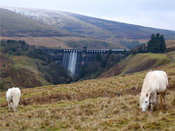
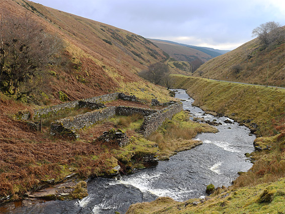
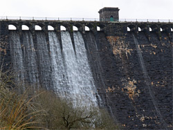
The path from the Grange zigzags up a grassy slope, crosses a small stream then heads diagonally up the steep sided-ridge that borders the full length of the Vale of Ewyas, running just south of a particularly craggy, dark-coloured section known as Tarren yr Esgob. One more switchback takes the path above the escarpment to the much more gently sloping land beyond, and eventually to the crest, where it meets the main ridgeline path. Waun Fach is now visible, 2 miles west across the valley of Grwyne Fawr. The nearest on-trail route down to the valley floor is northwest along the ridgeline for 0.7 miles and along a linked path that descends to the dam forming Grwyne Fawr Reservoir, but slightly quicker is to walk directly down the hillside ahead; this is boggy, and in places covered with uneven, tussocky grass typical of the Black Mountains, but the cross-country walk is not too difficult. The lower slopes are very steep, however. Just below the reservoir are a couple of aged stone sheepfolds, beside the upper end of the road through the valley, 1.7 miles from the furthest publicly accessible point; the last section of the road is for dam maintenance only. Water cascades from the top of the dam then flows over several weirs, creating small waterfalls, and although all the area around the base is fenced off, the views from a distance are still impressive.
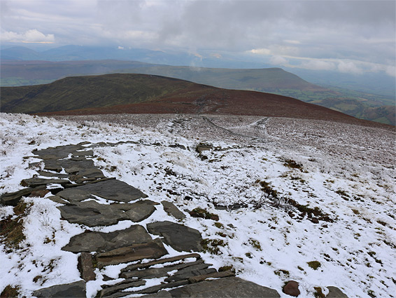
There are no paths up the west side of the Grwyne Fawr valley near the reservoir, but Waun Fach is quite easy to reach, first by climbing up the hillside to the dam and then following a small stream (Cwm Grigws-unchaf), which forms the western arm of the reservoir and leads directly to the summit, climbing 800 feet over just less than one mile. The summit is marked by a cairn, beside the junction with the ridgeline path that runs north to south, and another path to the west. The surroundings are nearly flat so the views are limited at this point, but to the north, the path descends and soon comes close to the western edge of the ridge, where all the undulating lands below are properly visible for the first time, and then stays close to the edge for the next 1.5 miles, past the lesser summit of Pen y Manllwyn (2,522 feet) and on across nearly level ground to the next (four-way) junction, now overlooking the Wye Valley to the north, at the upper end of the steep, rocky ravine of Cwm Cwnstab.
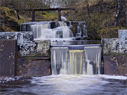
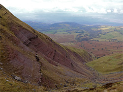
Continuing straight on, the path rises to another indistinct summit, 2,339 foot Rhos Dirion, and drops gently down the far side, along the ridge of Rhiw y Fan to another four-way junction, at a pass at the head of the Nant Bwch valley. Just before is a ravine down the north side of the ridge, one of the few places hereabouts where the underlying Old Red Sandstone is exposed and is still red in colour, rather than the weathered black or greys of most outcrops. Turning right at the junction, the trail descends alongside an initially small stream, which becomes confined within a steepish gorge, as the Nant Uchaf tributary joins from the west, and develops into a forceful stream, flowing over a sequence of small waterfalls, some distance below the path, though this later descends to the water level beside one such fall, cascading over a sandstone ledge. A gate not far beyond marks the edge of public land, and the path soon becomes a vehicle track and then a paved road, which leads to Capel-y-ffin.
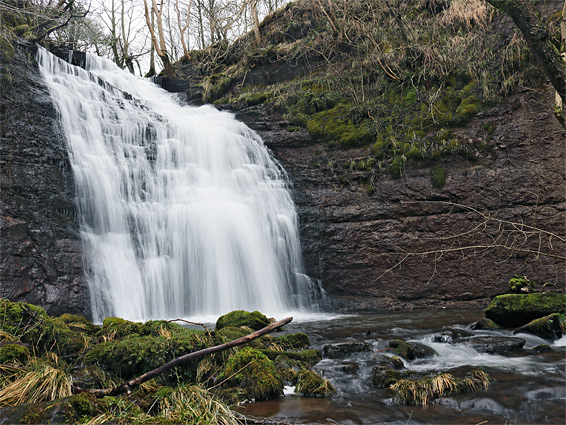
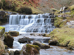
An alternative to walking on the track and the road is to take a faint path over to the far side of the stream, beginning just below the ledgy waterfall; this soon crosses another tributary (Nant Isaf), beside an aged, mossy sheepfold, then traverses a steep section of hillside, often very muddy and slippery, and is soon high above the Nant Bwch, which has descended into a steep-sided, tree-lined gorge that contains a hidden waterfall. There is no path to the fall, which can be heard from some distance away, but it can be reached by walking over a grassy area that separates the path from the river, a little way beyond the steep, slippery section and half a mile south of the tributary, then walking down the muddy, rather unstable slopes to the river and finally upstream a short distance to the base of the falls. The drop of the waters is about 50 feet, over a black-rock cliff into a shallow pool. In wetter weather other minor falls tumble down the muddy sides from all directions. Back above the gorge, the path continues southeastwards and splits into two, running either side of a smooth grassy hill; and both sections rejoin and lead back to the trailhead at the Grange.