Famous limestone ravine at the south edge of the Mendip Hills, containing several caves, and viewable via a 3 mile loop trail. The hike is free but the caves are expensive
Location
Cheddar, Somerset; parking for the hike is along the B3135
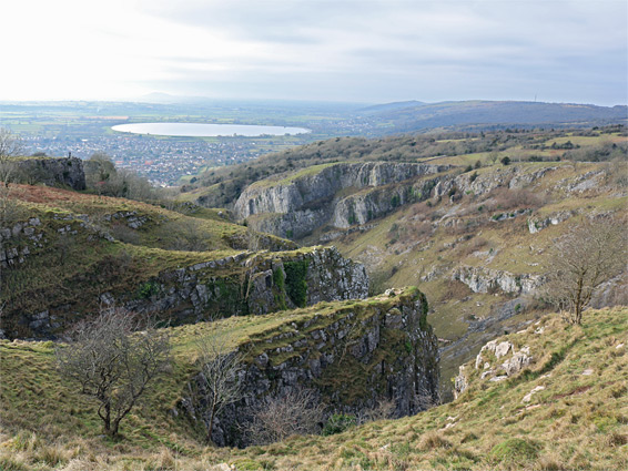
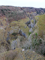
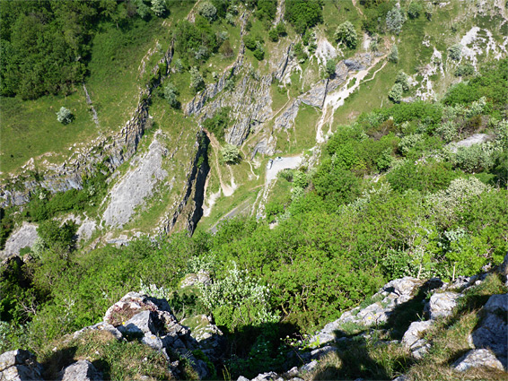
Cheddar Gorge, an Area of Outstanding Natural Beauty, is by far the most spectacular of several steep-sided valleys along the south edge of the Mendip Hills in Somerset, and one of the best known geological features in the whole country. The gorge is up to 450 feet deep and the main section is 1.5 miles long, as far as a junction, above which it splits into three upper tributaries. One of these, beginning just northwest of the village of Charterhouse, contains a series of springs that sustain a short section of stream before the waters sink below ground, re-emerging at the lower end of the gorge as the Cheddar Yeo, a short river that is impounded to form a reservoir on the far side of the adjacent village of Cheddar. The full length of the gorge is 3 miles, still small in comparison with canyons in other parts of the world, but apparently the largest in England. Access to the gorge is via the B3135, which runs right through the valley.
The Cheddar Yeo flows through one of several caverns in the lower reaches of the gorge (Gough's Cave), and is considered to be the longest underground river in the UK. Most of the passageways are partly or completely flooded and are open only to cave divers, but the half mile nearest the entrance is developed as a show cave, and for many people this is the main reason to visit Cheddar. The smaller Cox's Cave is also open to the public, whilst several lesser openings may be seen towards the base of the cliffs near the canyon floor.
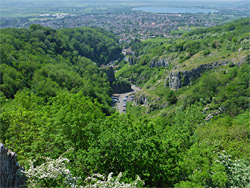
Cheddar village is filled with numerous souvenir shops, and the whole place has acquired a reputation for being over-commercialised, and expensive to visit. The caves, and all of the south side of the gorge, are part of the Longleat Estate owned by the Marquess of Bath, and they provide a substantial yearly income. A single type of ticket covers all attractions, which comprise the two show caves, the Museum of Prehistory (based around Cheddar Man, a 9,000 year-old skeleton discovered in a cave in 1903), and open-top bus tours, plus a set of 274 steps known as Jacob's Ladder, which climb the southern cliffs. 2017 prices are nearly Ł20 per adult. Also advertised as being included are a lookout tower on the south rim of the gorge, and the Cliff Top Walk, a 3.2 mile loop, however both these are free to access. The walk, perhaps the best activity hereabouts, runs along the top of the cliffs on both sides of the gorge, descending to the village at the west end. Land to the north of the gorge is owned by the National Trust and there are several free parking areas within the ravine near the path; a fee is charged for parking in town, and for places lower down the gorge road.
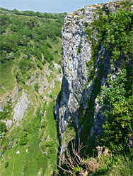
The exposed rocks of Cheddar Gorge are carboniferous limestone; all the cliffs and most of the north rim plateau are part of the Clifton Down Formation, while the south rim and a small area of the north rim are from the underlying Cheddar oolite. The south side of the gorge is bordered by sheer cliffs, popular for rock climbing, while the north side is steeply sloping, partly grassy, with a few steep scrambling routes between road and rim. The ravine was formed during alternating periods of glacial freezing and thawing; in warmer conditions the river flowed underground, through caves in the generally quite porous limestone, while in colder times the passageways were frozen and the waters stayed above ground, carving the gorge. The strata are inclined at a constant angle of about 20 degrees, sloping towards the southwest, and part of a very large deposit over half a mile thick; only the uppermost section is exposed.
Cliff Top Walk
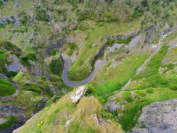
Driving through the gorge is one way to appreciate the scenery, and there plenty of parking places at which to stop and inspect the rocks close up, but the best views are from above, along the 3.2 mile Cliff Top Walk, which involves climbing and descending 700 feet. The walk can be started at the west end of the gorge, in the village, but the upper end is preferred as parking is free.
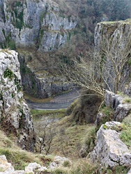
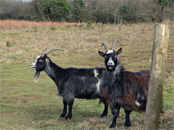
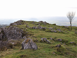
The loop path crosses the road 1.2 miles east of Gough's Cave, just as the highway bends from east-west to north-south. Verges on either side have space for about a dozen vehicles, and there are more spaces at short distance east. North seems to be the recommended direction to start, and the path here climbs through a patch of woods, passes a fence then turns west, ascending more via a long series of wooden steps, up an often muddy hillside, to the flat, grassy land on the rim, which gives the first good views of the gorge below. The adjacent rocky fields are home to a small flock of soay sheep, an agile species that also roams the upper levels of the ravine, as do the goats that were introduced here in the 1970s, to stop the slopes from becoming too overgrown. The trail stays fairly level for a few hundred yards, running across bushy terrain, before starting a descent where it is initially shielded from the gorge by a thick band of trees, but comes close again above a tight curve known as Horseshoe Bend. A side path descends a little way further, through a gap in a broken stone wall, to a fine viewpoint of the lower end of the canyon, and another spur just beyond leads to the edge of a promontory (Heartleaf Bluff) for more grand views. The main trail moves slightly north and descends more steeply down a thickly wooded valley, its floor covered by rocks and roots, before entering a grassy area and meeting Cufic Lane, a side street off the B3135, at the edge of the village.
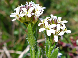
The southern section of the cliff top walk is not signposted from the village; it is reached by The Lippatt and Lynch Lane, two residential streets. The path starts off the latter road, rising through woodland and emerging to a clearing at the foot of the lookout tower, a metal structure dating from 1936, replacing an earlier wooden tower built by Roland Pavey, a local explorer. The viewing area on top is accessed by 48 steps. Just beyond is an unsigned junction with the path up from Gough's Cave (Jacob's Ladder), which is one of the features only open to purchasers of the gorge ticket. The trail continues ascending over the next half mile, mostly shielded from the gorge by trees, until the land opens out and several lesser paths loop past viewpoints on top of the cliffs, including four promontories named High Rock, Wind Rock, and (the two) Pinnacles, soon after which is the highpoint, 830 feet. The edge of the cliffs hereabouts is the best place to see the rare wildflower Cheddar pink, native only to the gorge and Sand Point. The final section of the route, after bearing left at a junction, descends slightly whilst running alongside a wooded area, and drops down more steeply through the trees, back to the Black Rock parking area, on the south side of the B3135.