Spectacular, steep-sided, 5 mile section of the north Somerset coast, explorable by trail across the grassy bluffs above the cliffs, or by walking along remote, stony beaches at sea level
The Somerset coastline west of Minehead, along the north side of Exmoor National Park, includes the highest cliffs in England, where the land rises very steeply, by up to one thousand feet. The easternmost section is the 5 mile stretch between Minehead and the wide, pebbly beach bordering Porlock Bay, and here the hills are only a little less tall than those further west - up to 800 feet, covered by short grass and wildflowers across the upper reaches but bare rock lower down. All the land hereabouts is formed of Hangman sandstone, a dark grey rock from the Devonian Period, tinged green and purple in some locations.
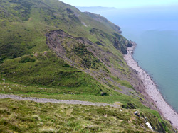
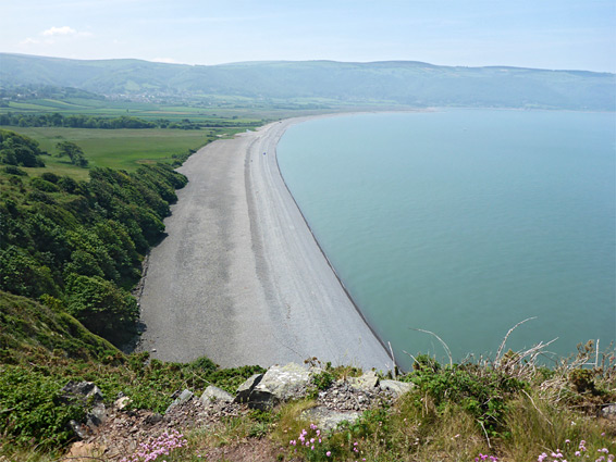
Inland, the ground rises to a ridge, centered on a 1,010 foot hill (Selworthy Beacon), which is steep at its west end, but less so to the east, and this side provides the course for a scenic, dead-end road from Minehead, the only access route to the area; the major north coast road, the A39, runs along a valley further south, well away from the sea. The main coast path is also mostly out of sight of the Bristol Channel, instead staying quite close to the road, a mile or more from the shore, though several smaller paths are closer and have better views, traversing the steeply sloping hillsides. Starting from quite thick oak woodland adjoining Minehead, these routes cross open, treeless slopes to the spectacular, rocky promontory of Hurlstone Point, site of an abandoned coastal lookout station. The cliffs end abruptly just beyond here, replaced by the pebbles of Bossington Beach at Porlock Bay; the high ground resumes a couple of miles away on the far side.
The hike to here is 5 miles from Minehead, where parking is limited and subject to a fee, or 4 miles if starting along the ridge access road, were spaces are less restricted, and free. One option for a more varied hike, described below, is, at low tide only, to walk all along the coast at sea level, at the foot of cliffs, returning via the lowest of the cliff-top paths above - a loop of 8.5 miles. For the shoreline walk, a few places may require a little scrambling to overcome projecting rocks, and care is needed in order to avoid being stranded by the incoming tide, though there are various places were climbing inland is possible, up little ravines.
Note that a recent (August 2021) report suggests that the unofficial route up from the beach below Hurlstone Point has been partly washed away, so making the connection to the coast path more difficult.
The coast path leaves Minehead at the end of Quay Street West, at the harbour, where limited fee parking is available. The trail runs along the edge of a grassy area then through a patch of woodland before meeting a vehicle track to a private residence (Greenaleigh Farm), before climbing a forested slope and moving away from the coast. The beach at this point is wide and stony, and is also easy to walk along. The alternative, free, access to the hike is along Moor Road, later Hill Road, to a junction a quarter of a mile west of Minehead Caravan Park; a short side track heads into the woods, and has plenty of parking spaces. This area could perhaps even be suitable for free camping, since the track ends in a spacious, secluded clearing, out of sight of the road.
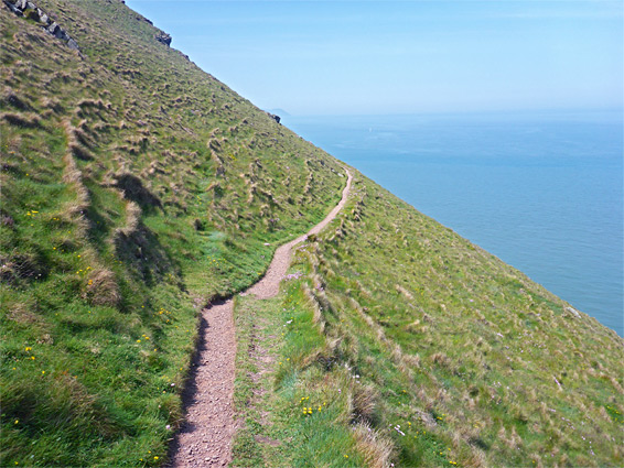
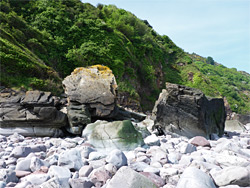
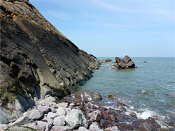
From the parking area along Hill Road, a wide trail goes west, but the hike begins on lesser path that heads north, through the forest; this descends gently and meets the Coast Path, which is followed east a short distance until it curves back west, dropping down much more steeply, and joining the track to Greenaleigh Farm. On the far side is a large field, and beyond this is a broad, pebble beach adjoining a small lagoon; this is Greenaleigh Point, bordered at low tide to the west by a sizeable patch of sand, though otherwise stony. Once across the field, the next 3.4 miles of the hike are all along the shoreline, which is uniformly covered by stones and boulders, and is for the most part fairly wide, but squeezed at various points by northwards-projecting strata. At the lowest tide times there are no significant obstructions but for a few hours either side the rocks create obstacles that may require climbing. The route is inaccessible at and near high tide.
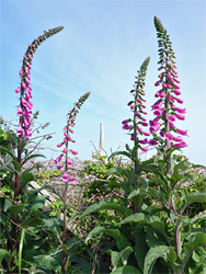
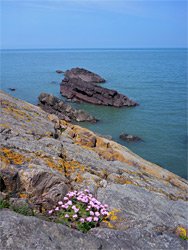
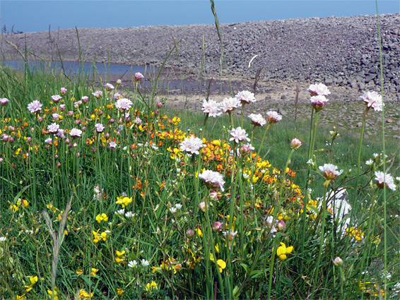
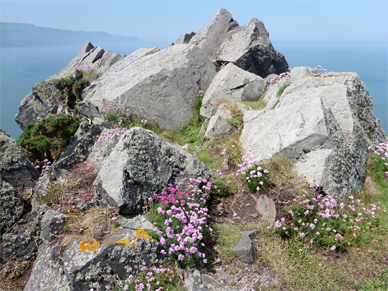
The general scenery is little changing; a succession of long, straight sections between minor bends, backed by some sheer cliffs but mostly by very steep slopes, split by five larger ravines that may contain little trickling streams, and many smaller gullies. The boulders are light grey below the high water mark, dark grey above, and there is much exposed bedrock, often inclined and folded. The most abundant flower species include sea thrift, sea campion and bird's-foot trefoil.
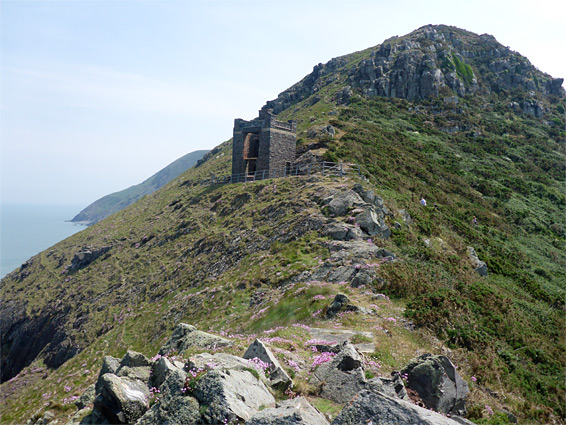
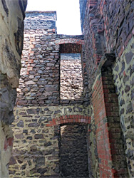
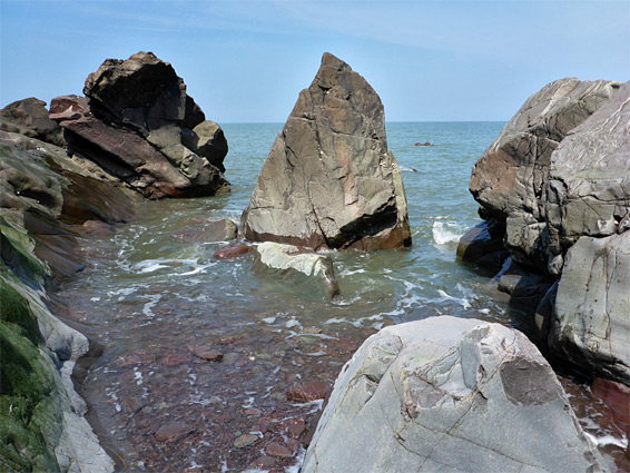
After 3 miles, larger rocks at the base of Hurlstone Point come into view, these impassable even at low tide. Just before is a slightly wider section of beach, with sand exposed at low water - this is Selworthy Sand, and the area may be reached, or left, via a rough, unofficial path that is aided by a cable along the lowest, steepest section - the part reported to be more difficult in summer 2021. This links with one of the lesser coastal paths, which a short distance west arrives at the spectacular headland of Hurlstone Point, overlooking the broad sweep of Bossington Beach to the west, which can be reached if desired by a short descent on another path. At the point stands the roofless ruin of a coastal lookout station, built in 1900 and abandoned sometime after World War II. The building was constructed out of the local reddish sandstone, and the stark masonry remains add to the beauty of the scene. The path continues down a slope towards the village of Bossington.
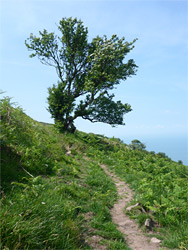
Two other trails run generally southwards from the point, one a spur off the Coast Path, the other a lesser route that follows the ridgeline up to the southeast, and this latter provides the most scenic return route. The path climbs a few hundred feet then divides again - the right branch also links to the Coast Path higher up, while the left fork stays fairly level, running beneath a low, rocky ridge and later curving round the broad, partly grassy, partly scree-covered valley of East Combe. After here the route bends north, coming close to the sea for the last time before heading away again, around the next, larger valley (Henners Combe), and proceeding across empty, grassy slopes that offer grand views west and east. The final section of the hike is southeast, along a temporarily overgrown valley, out over open terrain and eventually meeting the Coast Path, from where the parking area is half a mile away.