Intertidal terraces, sea caves, eroded formations, grassy bluffs and inland cliffs, along a three mile section of the Gower coastline, explorable via the coast path or by walking across the beaches below
Location
Oxwich, on the south side of the Gower Peninsula; SA3 1LS
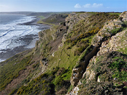
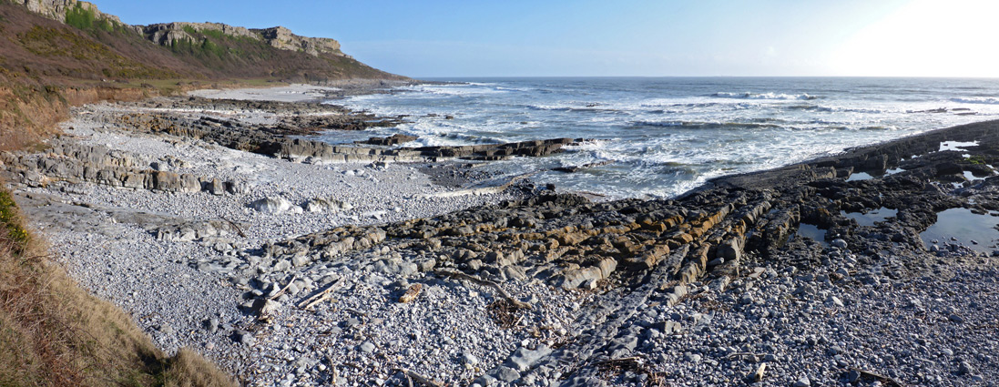
Between the popular sandy beaches at Oxwich and Horton, near Port Eynon, is a three mile section of rocky shoreline that is much less visited, despite being followed by a scenic section of the coast path, running mostly along a grassy bench at the foot of a line of limestone cliffs up to 200 feet high. Below are narrow beaches of sand or pebbles, and extensive wave-cut terraces and ridges, accompanied by numerous tide pools and eroded rock formations, in a wide band up to 1000 feet across at low tide.
In most places it is easy to climb down from the path, and the walk along the intertidal zone is also fairly straightforward, so one option to explore this section of the coast is to walk across the rocks and return via the path, thus seeing the shoreline from two different perspectives; such a walk is possible for about half the time, either side of low tide.
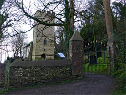
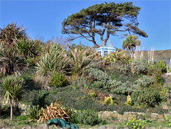
The best, and longest section comprises the south-facing cliffs lining Port Eynon Bay, since further east, where the land curves round the broad peninsula of Oxwich Point, the north-facing slopes are thickly wooded, sloping steeply down to a rather narrower intertidal zone with less interesting formations. Here the coast path rises high above, to bypass an unstable region subject to occasional landslips, most recently in 2009 and 2019. One other notable site along this stretch of the path is the ancient parish church of St Illtyd's, set in a woodland clearing overlooking Oxwich Bay, while Oxwich itself is also near two other major attractions; the dunes, wetlands and woodland of Oxwich National Nature Reserve, and the imposing remains of Oxwich Castle.
The 7.5 mile round trip between Oxwich and Horton, a quiet village overlooking the east end of Port Eynon beach, takes around four hours or more. The walk can begin at Horton in the west or Oxwich to the east; both are served by fee-paying car parks. For Oxwich (the route described below), free parking is available in several laybys along the road up to Oxwich Castle, though all are likely to be full at busy times of the year, when visitors can number in the hundreds.
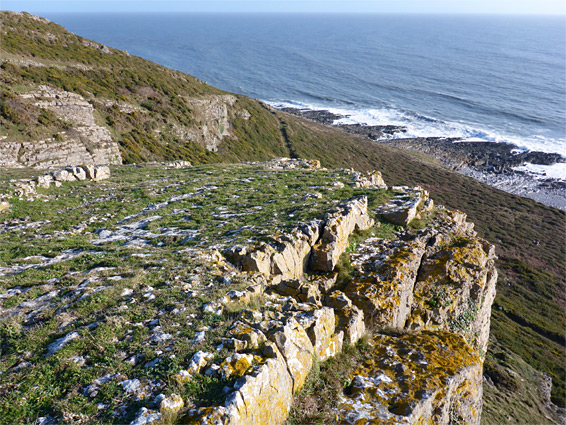
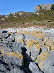
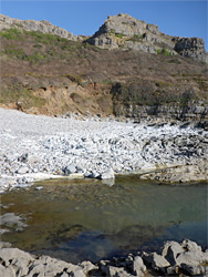
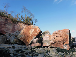
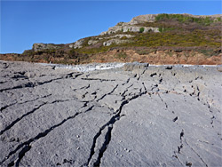
A dead-end road runs southeast from the centre of Oxwich village, past the Oxwich Bay Hotel, then narrows to an unpaved track, entering Oxwich Wood and continuing a few hundred feet to St Illtyd's Church, which was established in the 6th century though the current building is from the 13th and 14th centuries, or later. The church is usually kept locked so only the exterior can be inspected, plus the graveyard - a shady, moss-covered enclosure set beneath large trees, with good views across Oxwich Bay. Just past the church, the coast path starts a steep ascent to bypass the landslip region, while the beach is easily reached by a short climb down at the edge of the forest. Here, the intertidal zone is not particularly scenic, a jumble of seaweed-covered rocks and muddy patches, but the first interesting location is reached after a quarter of a mile, the site of the 2019 and 2008 landslides, at one of three abandoned quarries on this part of the coast; several house-sized boulders have detached from the hillside, one still topped by a group of trees. The rocks are from the Oxwich Head Limestone Formation which forms most of the coast between Oxwich and Port Eynon, generally grey in colour but sometimes stained pink or red due to iron oxide.
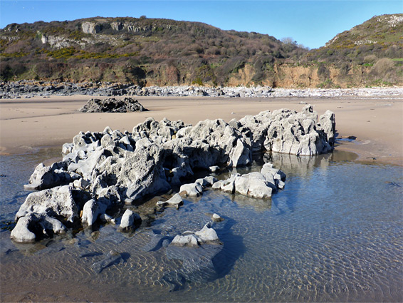
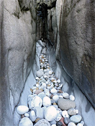
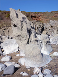
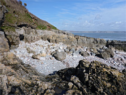
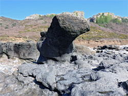
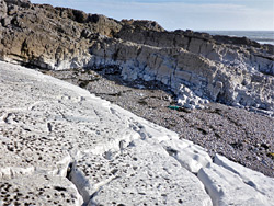
South of the landslip, the band of muddy limestone terraces below Oxwich Wood stays relatively wide for a while then narrows, and the otherwise flat rocks are crossed by a few upturned ridges. In some places the rocks are pitted with many small, circular rock pools, often containing anemones and shellfish. A few patches of sand are exposed at low water levels as the land curves round to the west, at the tip of Oxwich Point, beyond which the tidal rocks are more uneven, incorporating a few taller ridges and cliffs running perpendicular to the shore, this now lined by short grass and gorse bushes, since the ancient trees of Oxwich Wood extend only to the point. The rocks become gradually smaller and so easier to traverse over the next half mile, up to a minor headland, past which much more of the coast comes into view, as far as Port Eynon Point, 2.5 miles away. The limestone terraces widen further, flatten out more and mingle with small pebble beaches, and the shoreline stays similar for the next mile, without so much of interest, up to a mostly rock-free beach named The Sands. The eroded limestone terraces on the far side are bigger once more, containing several ravines leading to short caves, plus a good variety of other photogenic formations, and extend towards another minor headland. Past here the rocks gradually fade away, replaced by the sands of Port Eynon Bay. The northeastern section of the beach is known as The Cove, a circular patch of sand and pebbles lined by limestone terraces, one section of which is pure white in colour.
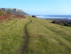
The main part of the beach at Horton starts 800 feet west of The Cove, with whitish pebbles around the high water mark and sand below, overlooked by a line of houses and private clfftop gardens, the first access point being just beyond; up a short path to the residential lane, leading from the main carpark in Horton. Turning right, the road soon ends in front of the easternmost house, where the coast path continues, signed Oxwich 3.5 miles. The path is narrow and enclosed at first, running between two tall hedgerows, then traverses bushier terrain above the rocks either side of The Cove, around the minor headland and out to grassy fields, above The Sands, where several routes lead down to the beach. The fields are initially fenced, and seasonally grazed by sheep, then later unfenced, but otherwise the scenery is similar in appearance - flat land beside the path, sloping steeply up a short distance inland, initially to bushy slopes and later to sheer limestone cliffs; comparable to the coast west of Port Eynon, this area seems especially remote and isolated, out-of-sight of any development. There is one connecting path, heading northwest to link with another route on top of the cliffs, but otherwise the rocks above the path are rather inaccessible, because of dense bushes below, though a few sheep trails provide other routes.
Another junction, in the vicinity of Oxwich Point, is with a path to Oxwich Castle, 1.2 miles away. Around here the main path moves away from the edge of the coast, climbs slightly, rounds a corner and enters the south end of Oxwich Wood, after which the sea is mostly hidden by the trees. A sign marks the edge of the Oxwich National Nature Reserve, which includes all the woods as well as the dunes and wetlands bordering the western half of Oxwich Bay. The trail stays level for half a mile then starts a steep climb to the upper (west) edge of the wood to bypass the unstable area above the quarries and landslips, and finally descends via many mossy steps, back to the edge of the beach beside St Illtyd's Church.