Like many other castles in the Welsh Marches, Wigmore Castle was founded shortly after the Norman conquest, in this case by William FitzOsbern (1st Earl of Hereford), though nearly all of the visible remains are from the 13th and 14th century rebuilding, carried out by several members of the Mortimer family. The castle was never captured or significantly damaged in battle, and remained at least partially occupied until the Civil War, when it was deliberately damaged in order to prevent any possible use by Royalists, and subsequently abandoned. In the centuries since, the ruins have become partly buried with rubble, and greatly overgrown, yet have not been subject to any excavations or repairs apart from minor restoration in the 1990s, largely to improve visitor access, so the castle is now one of the very few significant medieval fortifications with substantial ruins that are unaffected by modern alterations.
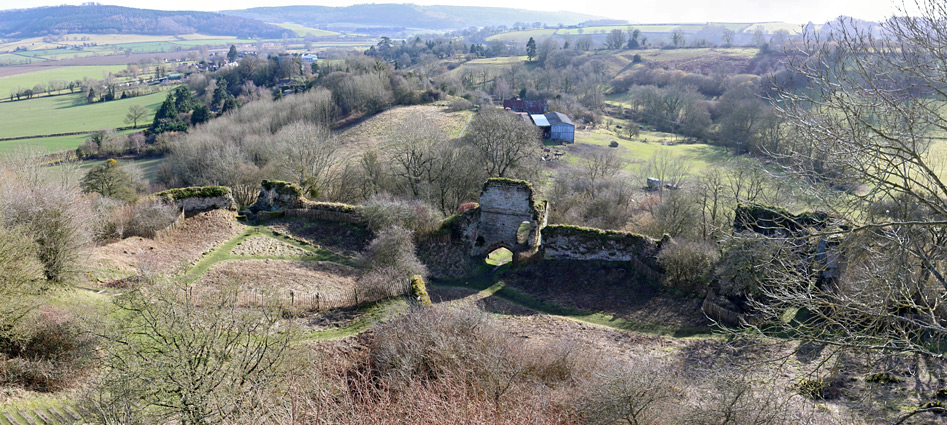
The ruins consist of parts of the keep, atop a steep-sided mound, below which are several lengthy sections of curtain wall enclosing an inner bailey incorporating an H-shaped gatehouse and parts of four towers, of which three were substantial, rising at least three stories, while beyond this are earthworks from the outer bailey. All is situated on a wooded spur of land projecting southeast from a more extensive hilly area, the Wigmore Rolls. Despite the substantial ruins, the site is not well known and does not see many visitors, presumably due to the rather remote location and because a half mile walk is needed to reach the site from the nearest parking area, in the adjacent village of Wigmore.
The ridge on which the castle was built overlooks a major cross-country route to the east - a corridor of flat, marshy land (Wigmore Moor) linking two significant rivers, the Lugg to the south and the Teme to the north. The travel route had been in use at least since Roman times, when the valley provided a course for one section of Watling Street. Several other hill forts were built in the vicinity, also overlooking the valley. The Wigmore site was transferred to the Mortimer family in 1075, four years after William FitzOsbern was killed in battle; at this time it was still a relatively modest timber fortification, and continued in this state for at least another hundred years before the first stone components were built, initially the keep and the curtain wall around the bailey to the southeast. Additional masonry improvements were carried out in the 13th and 14th centuries, and the castle flourished until 1424, when the last Mortimer Lord died, and the castle passed to Richard, 3rd Duke of York, after which occupancy declined, and towards the end of the 16th century the place was mostly used as a prison, following a series of repairs. After several more changes of ownership, the castle passed to the Harley family, supporters of Parliament during the Civil War, and it was they who ordered its partial destruction. The site swiftly became overgrown and remained virtually untouched until the small-scale excavations of the 1990s, under the supervision of English Heritage.
Wigmore is 8 miles southwest of Ludlow and 21 miles north of Hereford, along the A4110. The designated parking place for castle visitors is in front of the village hall, along a secondary lane on the east side of the village, from where the entrance is a half mile walk westwards; along the lane, over the main road, up Castle Street and School Lane, this alongside the partly Norman parish church, then finally along a footpath which climbs gently towards the forested ridge containing the ruins.
Exterior
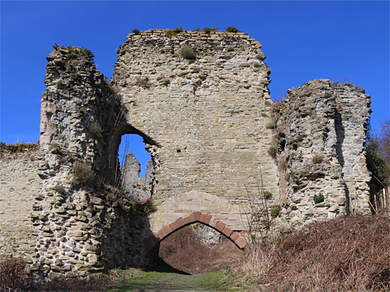
The path passes some grassy mounds, part of the outer defences of the castle, and enters the site of the outer bailey, an approximately rectangular area about 400 by 300 feet in in size, once enclosed by a low wall, of which no trace remains. The southern half of the site is now occupied by a house and some private land. Originally the bailey contained wooden subsidiary buildings including granaries and stables. The path continues northwestwards to the ditch that separates the outer bailey from the main protected area, on higher ground, now quite thickly wooded. A 0.3 mile path circles the castle at the base of the steep slopes below the curtain walls, and gives some of the best views of the surviving sections of the walls, and the four towers, at least in winter since in summer most is obscured by the leafy trees. Another path climbs a flight of steps to the main gatehouse (mostly 14th century), of which the middle portion survives, centred on a pointed arched doorway, buried by earth to about half its height. The two-order arch contains a recess where a portcullis once operated. The surviving walls of the gatehouse include the remains of a small first-floor room and a short passageway, plus a window, part of a doorway, and the base of a garderobe shaft.
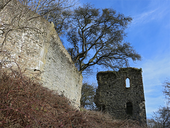
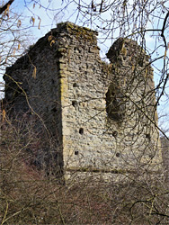
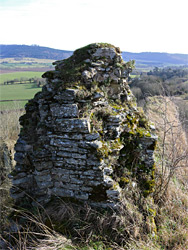
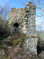
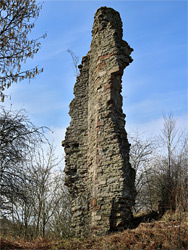
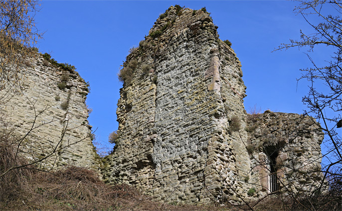
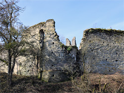
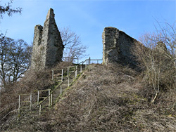
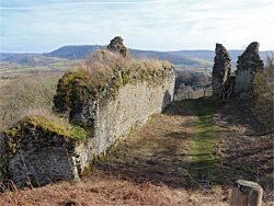
The gatehouse leads to the inner bailey, a crescent-shaped enclosure bordered to the northwest by the steep slope leading up to the shell keep. A few minor masonry fragments can be seen near the middle of the bailey, probably from a great hall, but all other structures are along the perimeter - part of a tower to the northeast, a 110 foot length of curtain wall centred on a round tower to the south, the gatehouse and the best preserved section of curtain wall on the west side, the south tower, a further section of curtain wall, the southwest tower, and finally a short stretch of wall half way up the bank below the keep. The east tower is round in cross-section and the oldest of the four, probably 13th century, while the other three towers are rectangular, and from the 14th century. The south tower is the largest; it was partitioned on the ground floor into two rooms, and retains several fireplaces and trefoil-headed windows. A longer flight of steps climbs the east side of the mound to the keep, entering through the site of the original doorway. The keep was an approximately overall structure with a gate tower on the east side and a larger residential tower to the west; remains are most of the north wall - up to eight feet thick at the base - a sizeable portion of the gate tower, a minor part of the south wall and a tall slender, isolated fragment of the other tower, which was at least three floors high; the relic includes traces of a spiral staircase, doorways and windows. The east end of the keep adjoins a short section of the curtain wall that once descended to the northeast tower.