The Malvern Hills are a comparatively long, tall and narrow range of uplands spanning the Worcestershire/Herefordshire border and extending south a little way into Gloucestershire, rising to a highpoint of 1,394 feet at Worcestershire Beacon, which is about 1,200 feet above the surrounding lower country - the flat plains of the Severn and Avon rivers to the east, and the more uneven terrain of the Welsh Marches to the west. The main section of the hills runs for five miles; an almost straight ridge orientated north-south, crossed by roads in just three places, though lesser hills at either end extend the ridge to around eight miles. All the peaks are formed of ancient Precambrian rocks, exposed by a series of folds and faults, and they are very resistant to erosion hence the ridge has remained high and steep-sided.
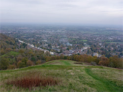
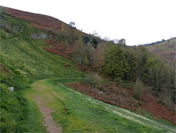
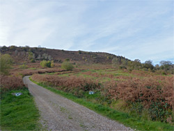
The lower slopes are partly covered with deciduous woodland, sheltering a good variety of wildflower species, while the upper reaches are mostly grassy, mixed with patches of bracken and brambles, with just a few rocky outcrops; the hills are for the most part smooth and gently undulating, and the immediate surroundings are not especially photogenic, instead the best aspect is the long-distance views, which to the southwest extend over 30 miles to the Brecon Beacons and the Bristol Channel. A sizeable proportion of the hills is unfenced, uncultivated public land, crossed by many trails, including a main route along or just below the ridgeline, a number of parallel paths lower down, across the grassy areas and through the forest below, and many link paths that connect with roads at the foot of the hills.
Because of the proximity to the large town of Great Malvern which sits below the eastern slopes, and since the hills are the only significant high country for a long distance, the Malverns are very popular, especially the northernmost section around Worcestershire Beacon, so solitude can be hard to find. Beside the views and the varied plant life, the hills are also notable for springs, quarries - all disused and several flooded - and historic sites, the largest being an ancient hillfort on Herefordshire Beacon, another of the highest peaks. The ridge lies at the centre of the Malvern Hills Area of Outstanding Natural Beauty, a 40 square mile region that also incorporates parts of the lowlands on all sides.
Roads divide the Malvern Hills into three sections, approximately equal in length (2 miles). The northernmost, centred on Worcestershire Beacon, is the closest to Great Malvern, and is accessible from many places along the A449 on the east side and the B4232 to the west. The middle section of the ridge, south of a pass near Upper Wyche, also has roads on both sides and rises to a highpoint of 1,177 feet, while the southernmost section, containing Herefordshire Beacon, is somewhat less accessible, with roads passing only at either end.
Paths
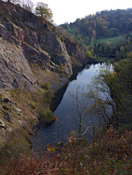
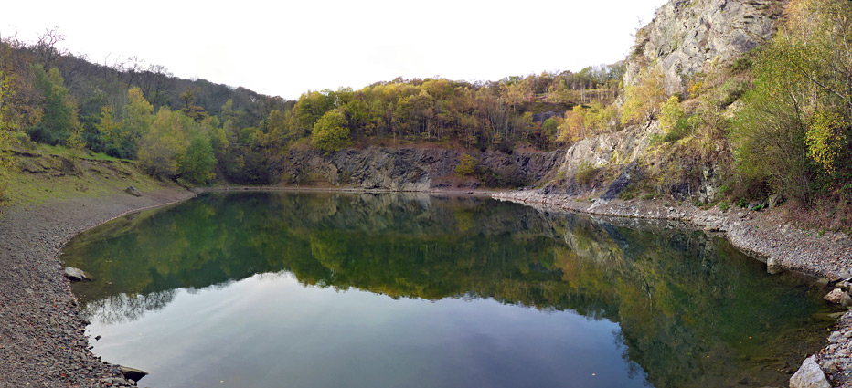
Most places on the ridgeline can be reached by short walks, of no more than half a mile, while for longer hikes the usual course is a loop, along the ridge and back on one of the lower paths; many routes are possible, ranging in distance up to 14 miles (round trip), for the whole length of the hills. An alternative, to see more of the scenery in a shorter time, is to take several shorter walks, and perhaps the best three would be the ridgeline of the northern section, encompassing Worcestershire Beacon, the path up to the hillfort on Herefordshire Beacon, and a visit to the most famous of the quarries, at Gullet, now a deep pool lined by dramatic cliffs.
Nearly all the designated parking areas close to the hills are managed by the Malvern Hills Trust, charged at a flat fee of £4 per day. Access points to the northern third include Tank Quarry and North Quarry along the B4232, at the north end, at West of England Quarry on the west side, from Great Malvern town centre, and at several locations to the south, around Upper Wyche pass. Worcestershire Beacon lies at the middle, its summit formed of a few exposed granitic rocks, partly covered in green lichen, while other notable summits are the slender Sugarloaf Hill and the rounded North Hill, the top of which gives the best views of Great Malvern. There is one significant ravine, on the east side (Green Valley), and at least ten overgrown quarries across the lower slopes.
The Centre
The middle, and narrowest section of the Malverns runs between Upper Wyche and Wynds Point, with roads along both sides, no more than half a mile apart. An ancient Bronze Age earthwork, Shire Ditch, stretches all along the crest, which rises to three minor, unnamed peaks, and slopes down gradually at either end. The ridgeline path is the most travelled route, and there are several parallel trails lower down, mostly on the east side. Parking places are also at either end, and at three locations to the west, along the B4232.
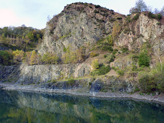
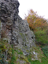
The most popular location in the southernmost third of the Malverns is Herefordshire Beacon, which is only a quarter of a mile from a large carpark along the A449, opposite the Malvern Hills Hotel. The hill and the two ridges at either side were the site of an extensive hillfort in the Iron Ages, known as British Camp, and several tiers of parallel terraces can still be clearly seen, culminating in a deep ditch and embankment around the flat summit, on which once stood a timber fortification from a medieval castle, that re-used part of the site. Shire Ditch follows the ridge, linking with the fort and continuing south towards the far end, which is accessed from a much smaller parking area near Hollybush Quarry, on land owned by the Eastnor estate. There is no parking fee at this location. The quarry is flooded and lined by steep cliffs; a photogenic place but difficult to view as the land at either side is privately owned, however the similar Gullet Quarry is open, reached by a quiet road across Castlemorton Common and a short walk down a residential lane. The waters are fenced off, in order to deter people attempting to swim, an activity that was recently banned following several deaths, though the place can still be explored quite easily. The main, north face of the quarry is notable for the variety of rocks exposed, representing a typical cross-section through the hills. As before, a variety of paths cross the southern third of the Malverns, none very busy; this area is more remote than the places further north, and the band of accessible land is wider, extending to the rough pasture at the foot of the slopes.