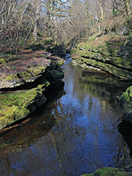
A pretty, tree-lined valley between Merthyr Tydfil and Pontsarn, containing a river that forms pools (including Pwll Glas), cascades and some narrow, sheer-walled sections. Explorable by paths along both sides of the river
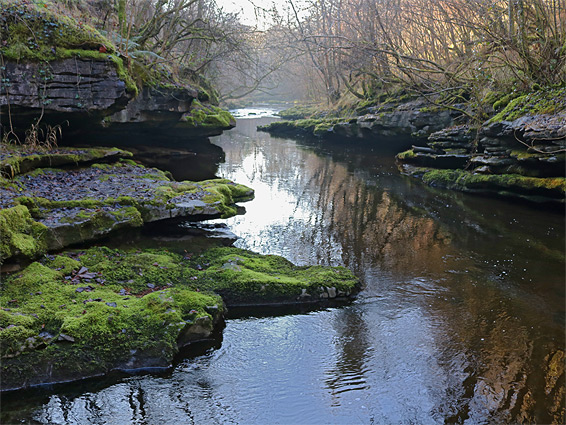
The Taf Fechan river begins in the wide valley beneath the two highest peaks in the Brecon Beacons (Pen y Fan and Corn Du), and flows south, soon impounded by dams to form four reservoirs, mostly lined by conifer plantations, then enters more developed land and meets the Taf Fawr on the northwest side of Merthyr Tydfil. The southernmost three miles are enclosed by wooded slopes, forming a valley that gradually becomes deeper and somewhat narrower, and for 1.5 miles the river is part of a shady gorge, bordered in some places by flat ledges and low cliffs of carboniferous limestone. The narrow sections are never very deep but are certainly pretty, since most rock surfaces are covered with bright green moss, and the dark, thin-layered strata are eroded to form a variety of photogenic shapes.
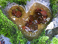
The most scenic stretch extends from the vicinity of the A465 bridge over the river, northwards to the next road crossing at Pontsarn, and all is protected as the Taf Fechan Nature Reserve; most is also within the Cwm Taf Fechan Woodlands Site of Special Scientific Interest. Along this section are no major waterfalls but many cascades, the best at the upper end, just downstream of Pontsarn, where the river flows through a narrow channel and into a large pool named Pwll Glas. The reserve is also noted for the ancient deciduous woodland and for patches of lime-based meadows, both of which support many plant species - wildflowers in the open areas, and bryophytes (mosses and liverworts) in the cool, damp forests.
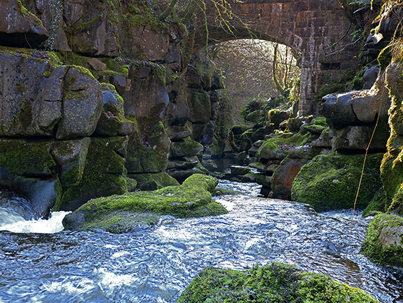
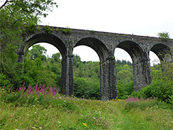
Like most of the south Wales valleys, the Taf Fechan Gorge shows signs of previous industrial use, including a limestone quarry, corn and fulling mills, an aqueduct that once served the Cyfarthfa Iron Works to the south, and the Pontsarn Viaduct, carrying a railway line built in 1867 and closed in 1966. The viaduct is just outside the nature reserve, within the adjacent Brecon Beacons National Park. Paths follow both sides of the Taf Fechan in the reserve, allowing for a loop hike of 3.7 miles, which can be extended to other destinations including the old railway line (which forms part of the Taff Trail), the ruins of Morlais Castle, or the valley further up the river; north of Pontsarn are no more narrow sections or major cascades, but the drainage is wooded and undeveloped for another 2 miles, until reaching the village of Pontsticill.
The closest parking to the south end of the nature reserve is along High Street (A4054) in Cefn Coed y Cymmer; the gorge is reached by walking across an old bridge over the river, just south of Maesgwynne roundabout, then turning right, down a short path. An alternative starting point is at Cyfarthfa Castle, a little further southeast, and from here a path goes through a patch of woodland, across Gurnos Road then runs for a short distance next to an aqueduct supplying Cyfarthfa Park Lake (originally used by the ironworks); this path links with the trail along the river. The north end of the nature reserve can be accessed from a parking area on the road just east of Pontsarn.
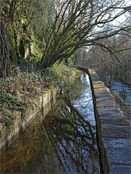
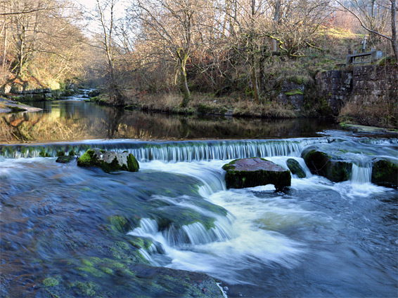
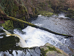
The river path, originally a tramway, follows the east bank of the river, parallel to the aqueduct, or leat, which initially is about 25 feet above but becomes gradually closer as the river gains height. This section of the gorge is narrow, bordered by streets above at either side, though is still enclosed, wooded and peaceful, just partly spoilt by litter. In some places water from the aqueduct seeps through the ground, making the path permanently wet. The river enters rural surroundings shortly before the A465 crossing, on a high bridge; to the east is an open, grazed area, good for wildflowers in the spring, and once the site of a rail yard serving the Gurnos limestone quarry. The aqueduct, which is now at the same level as the path, runs briefly underground then links with the river just upstream of a weir.
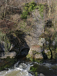
Below the weir the river is crossed by a footbridge from where paths continue north along both sides of the valley; the eastern trail is the main route, being wide, fairly level and somewhat closer to the river, while the western path is narrower, and moves away from the water in some places to overcome steep sections. Two hundred feet north of the bridge, on the west side, are the ivy-clad remains of an eighteenth century fulling mill above a small arch, adjoining an overgrown quarry that extends a little way south along the river bank.
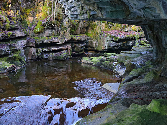
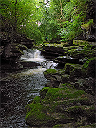
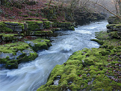
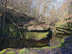
The next mile is the best section of the gorge, which has three main enclosed stretches, where one or both sides are bordered by low, ledgy, mossy cliffs, and the river alternates between pools and shallow cascades. The first is just beyond the ruined mill building, extending about 800 feet, while the second is about a quarter of a mile further, similar in length but deeper - the best part of the whole valley. These narrows are mostly out-of-sight of the western path, which rises above to avoid steep slopes, but can easily be seen from the east, perhaps by climbing down to walk at water level through the most enclosed section. After here the land is somewhat flatter, and less wooded to the west, where the trees give way to a bushy field. Across here is a short connecting path, from the village of Trefechan.
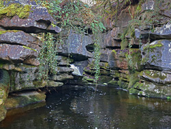
The last enclosed stretch is at the north end of the nature reserve; a short section of taller cliffs, partly overhanging, followed by a cascade, Pwll Glas ('blue pool'), a waterfall and then a briefly very narrow channel, extending right beneath the road bridge at Pontsarn. Unfortunately the bridge is a popular location for fly-tipping, so this naturally beautiful section of the gorge is usually disfigured by rubbish thrown from above. The eastern path moves away from the river before this narrow part, ending at the road, and the western trail also briefly climbs above, through a wooded area, then drops back down to a viewpoint of the pool, and meets the road. Beyond the bridge the narrow section continues just a short distance, above which the river is no longer enclosed, flowing from underneath the Pontsarn viaduct and then from a wider, still wooded valley. The hike can be extended by walking west or east along the old railway, further north along the river (the main path is now on the west side), or by climbing the steep slopes to the east to Morlais Castle, a third of a mile away.