Deep, wooded valley containing a powerful river that forms several waterfalls and enclosed sections; also caves, old railway lines and industrial sites
The River Clydach flows for six miles, from the southern slopes of Llangattock Mountain, north of Brynmawr, to the River Usk near Gilwern, and for about 2 miles is impounded by steep, wooded slopes to form the Clydach Gorge, or Cwm Clydach. Contained within are a few caves, several powerful waterfalls and many lesser cascades, as the fast-flowing waters descend by nearly 700 feet. The valley sides are in general too steep to allow paths to follow the river at water level, but the main falls can be seen by trails that descend from above.
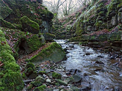
Because of the inaccessibility, the lowest parts of the gorge are little-visited, wild and unspoilt, despite the presence of the busy A465, Heads of the Valleys Road, which parallels the whole length, often only 250 feet from the river, though quite high above and mostly out of sight, if not out of hearing. The road is on the north side of the gorge, where the slopes are steepest; the land to the south is slightly more gentle, so the band of trees bordering the river is wider, and gives way to grassy slopes above, crossed by roads, paths, old railway lines and old tramways, reflecting the long history of industrial use. The area has been involved with lime extraction, quarrying, coal-mining and ironworks, the various industries flourishing in part due to the river that was used for powering machinery, and the extensive beech woods which provided timber, burnt to make charcoal for furnaces.
The gorge, therefore, has an interesting mix of natural and historical features, and varied scenery, from the shady, enclosed and hard-to-reach environment along the river, to the open slopes above, which have fine views towards the neighbouring peaks of the Black Mountains. The valley is part of Brecon Beacons National Park, and although close to the main road, is not often explored, since signage is limited, the access roads are narrow, and the variety of routes across different levels of the valley can be somewhat confusing.
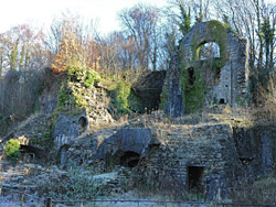
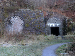
The deepest and most scenic section of the gorge is about one mile long, the section west of the village of Clydach, where the river and the dense woods on either side are contained within the RSPB-managed Cwm Clydach National Nature Reserve, on account of the many bird species that live here. The area can be accessed from the west, by walking from Brynmawr, but better is to start in Clydach, leaving vehicles in a small parking area at the end of Dan y Coed, a residential street. This forks off Station Road, which meets the A465 half a mile beyond. One site of interest en route is the Clydach Ironworks, a Scheduled Ancient Monument, reached by a short walk at the end of a little road - along a path on the north side of the river then back to the south side via a cast iron tramway bridge erected in 1824, one of the earliest such structures in the country. The ironworks were built in the late 18 century and present a pleasingly aged appearance, looking like the ruins of some ancient castle, mossy and overgrown. Parts of the site were excavated in the 1980s, and relics include furnaces, walls, tunnels and a wheel pit.
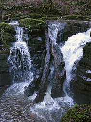
Lower Clydach Falls
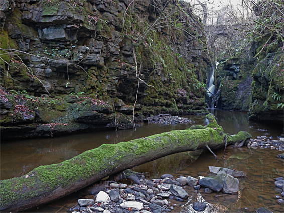
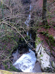
From the Dan y Coed parking area, a path heads west into the beech forest, along the course of a tramway from the ironworks. It forks after a few hundred feet - one branch continues along the tramway as it climbs the valley sides, while the other stays level, now running along a former aqueduct, and soon meets the river beside the Lower Clydach Falls, where the waters flow over two sets of cascades then into a deep, narrow section lined by sheer walls of black rock. The valley sides are too sleep and slippery to access this from below but there are several good viewpoints at the brink of the falls, and the river can usually be crossed just above via stepping stones or fallen trees, allowing views of the falls from the far side. Past the falls a fainter path continues a little way to a much smaller cascade then fades away as the land becomes steeper and more overgrown.
The next easily accessible part of the gorge is half a mile upstream, reached by following the other branch of the path along the former tramway, which rises to a junction with an old railway line (part of national cycle route 46), running just below the narrow Quarry Road, from Clydach. To the west, the railbed curves into the lower end of Cwm Llam-march, a tributary valley, bordered by cliffs on one side and a rocky embankment to the other, and disappears into the two Gellifelen tunnels, taking the line through a spur between the valley and an adjacent ravine to the west. One tunnel is open, and although only a quarter of a mile long, it is curved and hence completely black in the middle, so a torch is needed if exploring.
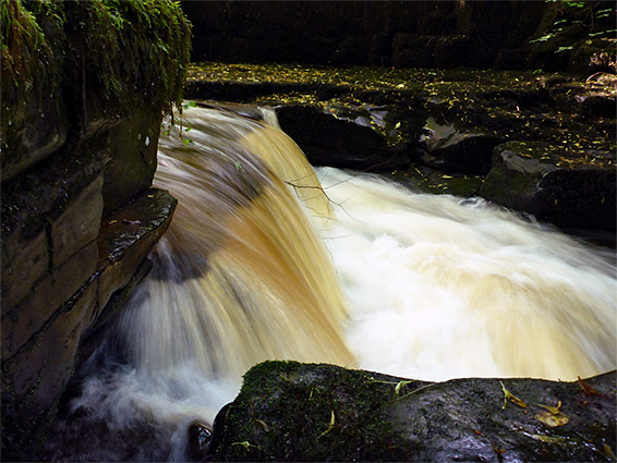
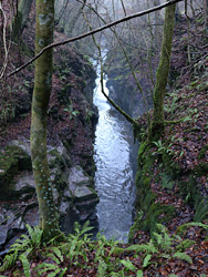
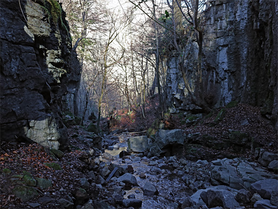
The usual continuation route is on a path that runs through woodland then links with a spur off Quarry Road, along which are a few houses, and soon after rejoins the railway line at the western tunnel entrance. Shortly before the tunnel is a steep path back down to the river, crossing it on Devil's Bridge, just above the second main waterfall in the gorge. The waters tumble through a narrow gap, over a limestone ledge and into a short but deep narrow section, followed by a big pool named Pwll-y-Cwn, a name which is also applied to the waterfall. The cataract can be viewed from the bridge, or a ledge to one side, though the steep slopes prevent attempts to walk downstream. The falls can still be seen from below however, plus the enclosed lower section of Cwm Llam-march and the intervening half mile of the gorge, by continuing westwards from the lower falls.
Cwm Llam-march and the Middle Section of the Gorge
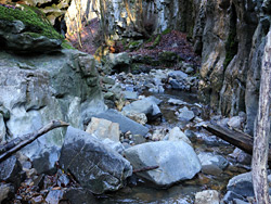
West of Lower Clydach Falls, a muddy path goes a few hundred feet to a lesser cascade then ends, as the land bordering the river becomes steeper, though this section can be passed by rising above then descending, down to another slightly enclosed section, and a second minor waterfall. The slopes hereabouts are steep, overgrown and permanently wet, causing the soil to be somewhat unstable and slippery. Beyond is a slightly flatter area, beneath a line of low cliffs that form just above, and extend to the tributary of Cwm Llam-march. The lower end of this is confined within a pretty, cliff-lined, boulder-filled gorge that contains a cave entrance on the east side, while above the confluence, the river also becomes enclosed beneath cliffs, leading to Pwll-y-Cwn. An ancient, mossy fallen tree trunk allows walking up the river without getting feet wet, to a viewpoint at the edge of the pool, where the falls, and Devil's Bridge, can be seen ahead. The cliffs and the slopes above make it impossible to keep following the river, but the old railway line can be reached by walking up Cwm Llam-march then climbing the embankment, to a point near the Gellifelen tunnels.
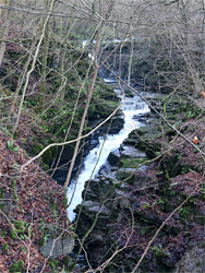
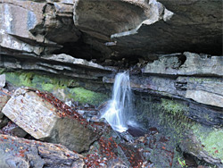
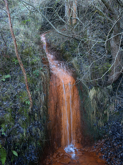
After the spur path down to Devils Bridge and Pwll-y-Cwn, the westwards route continues along the road a short distance and then the old railway, rejoining this near the western entrance to the tunnels. Just above is an old mine opening discharging a small stream, which has left orange iron deposits along its course. A short distance further, immediately after a disused white building, another path drops down to the river, here flowing through several cascades over big boulders, but of more interest is the mouth of Ogof Clogwyn, a well-known cave containing a stream that forms a small waterfall at the entrance. The cave can be explored relatively easily for around 1,000 feet, and is noted for the thin, parallel ridges along its sides, known as phreatic shelving. The river then enters a short, cliff-bound section, above which the gorge is noticeably less deep, and contains no more significant waterfalls.