Short but deep and scenic valley along the Sychryd River, a tributary of the Mellte, containing several powerful waterfalls and some old mine relics - within Waterfall Country in Brecon Beacons National Park
The River Sychryd is a short tributary of the River Mellte, flowing just 5 miles, initially across open slopes then through a wooded gorge to the confluence, on the east side of the village of Pontneddfechan. The gorge forms part of the southern boundary of Brecon Beacons National Park, in the area known as Waterfall Country which is famous for the many cascades and falls, on the Mellte and its tributaries, and several other rivers. Within the 1.5 mile Sychryd Gorge are three main falls, none with an official name but known informally as Sychryd Cascades, Sychryd Falls and Upper Sychryd Falls, along a quarter mile stretch towards the lower end of the valley.
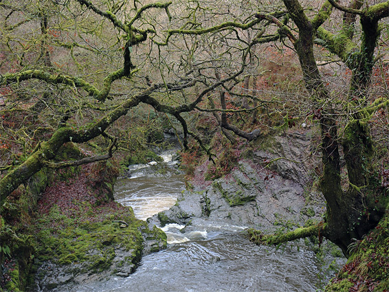
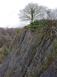
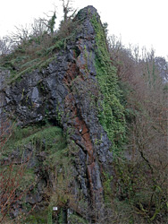
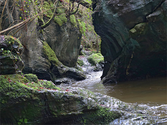
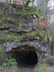
The gorge is mostly bordered by steep, overgrown, wooded slopes but for a short section between the lower two falls the river flows between vertical walls of dark, layered limestone, partly covered by bright green moss that also envelops all tree branches hereabouts, owing to the permanently shady, moist conditions - the depth and orientation of the canyon means that the sun almost never illuminates the river, even in winter when the trees are leafless. Two particularly large limestone outcrops have official names - Bwa Maen is a prominent peak formed of tightly folded strata right opposite the lower cascade, while Dinas Rock is a larger cliff face, overlooking the parking area at the end of the access road, and is a popular location with climbers. Also of note in the gorge are relics from the Dinas silica (or quartzite) mines, including several tunnels either side of the main falls, and the remains of a tramway that once ran beside the river. Two short paths lead to the lower falls, while the third, and the canyon further upstream, can be reached by walking off-trail.
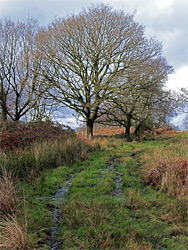
The (free) parking area at Dinas Rock is at the east end of Dinas Road, one mile from the centre of Pontneddfechan. The rock rises above the river confluence - Sychryd to the south, Mellte to the north, and the main trail from here, starting at the northeast side of the parking area, follows the Mellte for 2 miles to the Sgwd yr Eira waterfall along the River Hepste, and so links with the south end of the Four Falls Walk. About half way along, a path descends to the Mellte and visits the site of an old gunpowder works, plus another smaller waterfall, while another branch, reached much sooner, leads to the Sychryd Falls. The lower cascades on the Sychryd are accessed by a separate path, just quarter of a mile long and almost level, leaving from the south side of the parking area.
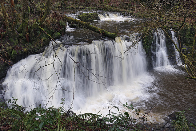
The southern path enters the lower end of the Sychryd Gorge, rounds a couple of shallow bends and ends at a stone bank beside the Sgydau Sychryd, or Sychryd Cascades, which are often powerful though not especially pretty. The dark peak of Bwa Maen is directly opposite, on the far side of the river, its stark appearance only slightly spoilt by several prominent No Trespassing notices, since all of the south bank of the river is privately owned. Just downstream are several minor cascades, before the river flows between two stone columns, supports of a tramway bridge that crossed at this point. Above the cascade to the north are the remains of a ledge that once provided a route upstream, linking with the nearby silica mine, though rockfalls have left this impassable, and the old route is fenced off at either end. It is possible, preferably at times of low water, to climb up the slippery rocks on the north side of the cascade and link with the end of the path above, but the route is not easy; much better is to return to the parking area and take the other trail. There is a slightly shorter option via an unofficial path, narrow and steep though lacking any great exposure, which climbs the south side of Dinas Rock and is mostly used by climbers. Once on top, the path runs along the flat plateau, site of an ancient hill fort, and soon meets the main route.
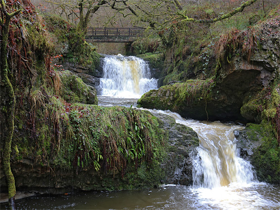
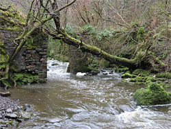
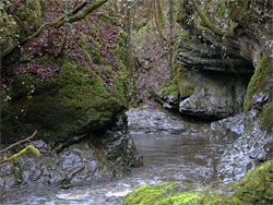
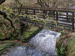
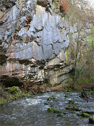
The trail on the north side of the parking area, signed to Sgwd yr Eira, climbs steadily at first, assisted by railings at one point owing to a short stretch of slippery rock, but soon flattens out, upon reaching the grassy land above Dinas Rock. The path arrives at a junction after a quarter of a mile; the route to Sychryd Falls is right here and right again immediately after, followed by a descent to the river, partly down a flight of steps. The falls, part of the best section of the gorge, have two upper stages, followed by a pool named Pwll y Berw and then a lower cascade, below which the river flows through a photogenic, narrow bend between polished black rocks and then alongside a tall, vertical limestone cliff undercut at the base and streaked with colourful lichen. After here are a few large boulders preceding the impassable drop above the lower Sychryd cascade. A path runs past these features, on the north side of the river; the final section is along the remains of the tramline, before a gate guarding the closed off-ledge. The various falls and narrow parts can be seen close up by very short climbs down to water level, some easier than others. The river is crossed just above the falls by a footbridge, originally built to connect two sections of the Dinas silica mines, other relics from which include an unobstructed tunnel on the south side and three adits to the north, loosely fenced off though easily entered if desired. The middle tunnel is the longest, extending about 450 feet.
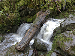
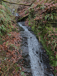
East of the Sychryd Falls a narrower path continues across boggy ground for a few hundred yards, then gradually climbs out of the forest, moving well away from the river. Not far beyond the point it begins the ascent is another photogenic cascade, more elongated than the others - Upper Sychryd Fall, reachable by carefully descending a steep slope, covered by bracken and brambles. Upstream of here are no more falls apart from a small feature near the upper end of the gorge at a pool named Pwll y Crochan, viewable most easily by a short hike down from a parking area along the A465, Heads of the Valleys Road. The reminder of the gorge is still quite pretty, however, with some shallow enclosed sections and two small tributaries on the north side, and it can be seen by continuing eastwards, either cross-country or along a faint path, until the ground becomes too steep to continue. This is just after the second tributary, in the vicinity of Tyle Morgrug cottage; from here, another way to return to the trailhead is up the slopes beside the tributary to the top of the gorge then northwestwards through woods and fields, eventually meeting the path to Sgwd yr Eira.