A short river, just 3 miles, flowing partly through a deep gorge containing two spectacular waterfalls, Sgwd Gwladus and Sgwd Einion Gam. Explorable from the lower end or further upstream
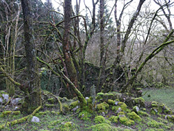
The Afon Pyrddin is one of the rivers of Waterfall Country, on the south side of Brecon Beacons National Park, and forms part of the boundary between Neath Port Talbot and Powys. Like some other rivers in the area it is short, just 3 miles, but contains two spectacular falls, named Sgwd Gwladus and Sgwd Einion Gam, plus a number of smaller cascades, mostly in the upper stretch, which flows through a generally shallow, wooded valley.
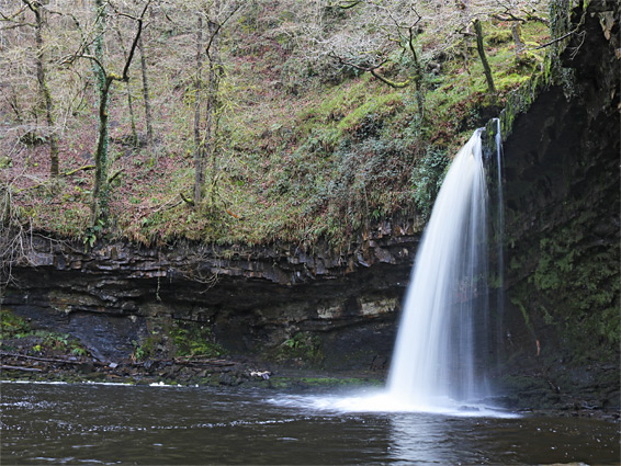
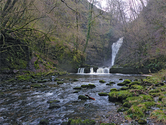
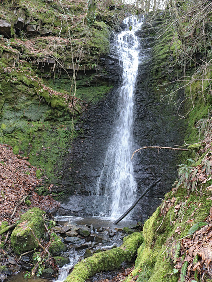
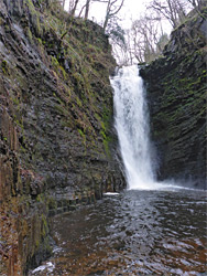
At 70 feet, Sgwd Einion Gam (fall of the crooked Einion) is the second highest waterfall in south Wales, and its surrounding cliffs create an impassable barrier between the steep-sided lower section of the river, and the less enclosed upper reaches, so these two areas have to be explored separately. Hardly anyone sees the river upstream, however, due to lack of any trails, but the lower portion is popular, at least as far as the first waterfall, Sgwd Gwladus (the lady fall), which is accessed by a wide, mostly level path. From here to Sgwd Einion Gam is only 0.6 miles, but again for most of the way there is no path, and the river needs crossing four times, wading through quite fast-flowing waters that are up to 2 feet deep during wetter times but are usually rather shallower. Both falls are named after semi-mythical Welsh figures from the 5th century; Gwladus, the lady, daughter of a prince, was enamoured of Einion, a local peasant, though their differing status meant that a relationship was not permitted, and they are said both to have died in the river.
The trail to Sgwd Gwladus starts at Pontneddfechan, initially following the River Neath (Afon Nedd Fechan) for one mile; the Afon Pyrddin is a tributary. Another path continues northwards along the Neath to three other large, named falls, and this river can be followed for several miles, until it breaks out of the forest into open countryside, as unlike the Afon Pyrddin it contains no major obstacles.
Parking for the usual approach to the Afon Pyrddin, from the lower end, is near Angel Inn in Pontneddfechan, either in a small area just to the east, or alongside the main road, the B4242. The adjacent Waterfalls Centre used to provide information about the whole region, until its closure in 2016. The hike begins at a gate on the north side of the inn, just west of the bridge over the river. The start point for walks to the upper section of the river is along the A4109 (Inter-Valley Road) at a junction with a gated track, 2.8 miles from the crossroads in Glynneath, or 2 miles from Pontneddfechan, partly along a very narrow track that climbs steeply beginning behind the Angel Inn.
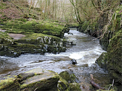
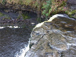
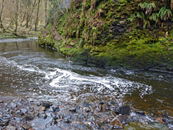
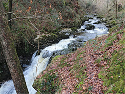
The trail northwards beside the Afon Nedd Fechan is wide and flat, following the course of a tramway that once served coal and silica mines upstream. The initial section of the river is quite dramatic, flowing down a shallow gorge framed by dark rock walls; above here the valley sides are mostly earthen, though still steep and thickly wooded, and the river crosses a few other rocky outcrops, forming cascades. Landmarks to the left include an unstable cliff, where the path is rerouted for a short distance away from the old tramway, followed by a huge overhanging alcove, and then the aged, crumbling ruins of the 14th century Pontneddfechan Corn Mill, fenced off and marked as dangerous to enter. Round a couple of minor bends are the remains of a bridge that took the tramway to some coal workings on the far side, and several tunnel openings can be seen, on both banks of the river, all securely sealed by metal bars. The continuation path, beyond the tramway, is slightly more uneven, and soon arrives at the Nedd Fechan-Pyrddin confluence, one mile from Pontneddfechan, centred on quite a large, deep pool.
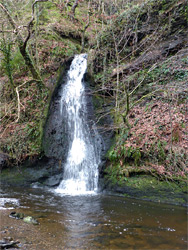
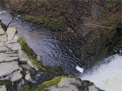
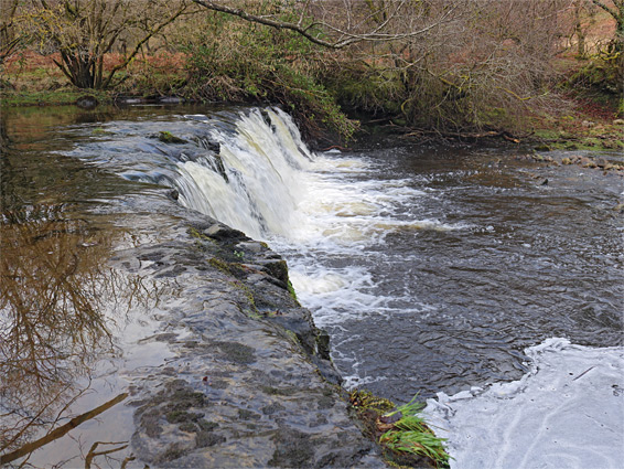
One path follows the south bank of the Afon Pyrddin to Sgwd Gwladus (1,000 feet) while the other crosses via a bridge and follows the Afon Nedd Fechan further upstream. The Pyrddin path passes one pretty, elongated cascade before ending at a designated viewing area about 200 feet below the falls, though it is easy to walk closer. The waterfall is 20 feet high, formed where the river flows over a thin ledge of resistant, light grey, sandstone above a thicker layer of darker and softer mudstone which has eroded away further to leave the ledge overhanging, and it can be up to 50 feet wide in floods though is usually much narrower. At times of low flow it is possible to walk behind the falls without getting wet feet.
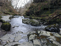
The route to the next, larger fall, Sgwd Einion Gam, can involve retracing steps back to the river bridge near the Nedd Fechan confluence, though a quicker option is to wade across the river below Sgwd Gwladus. A path on the far side curves up a slope and leads back to the river, allowing inspection of Sgwd Gwladus from above, and continues across sometimes boggy terrain for a few hundred yards, past a partly cliff-lined bend, to the first point where fording of the river is required, in front of another tall cliff of jagged black rocks (coal). The second crossing point is not far beyond, after a tighter bend, soon followed by the third, as the valley becomes narrower and straighter, and the waterfall can be seen ahead. The final crossing is back to the north side, not far below a powerful cascade framed by low cliffs, passable by a little path that drops back down near the base of Sgwd Einion Gam. The best view is from the south side, necessitating another crossing. This fall drops into a deep, narrow pool enclosed by somewhat intimidating, dark, moss-covered walls formed of a thin-layered sandstone known as Farewell Rock, a thick, resistant stratum at the base of the south Wales coal measures. There is absolutely no way to climb beyond the waterfall going to the sheer or very steep sides; to see this location from above requires a separate hike, starting from the upper access point.
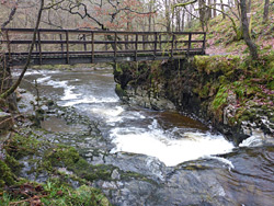
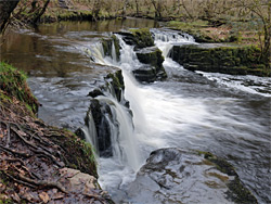
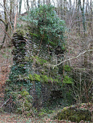
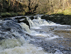
From the junction along the A4109, the track winds down a grassy, sheep-grazed hillside and crosses the Afon Pyrddin after 0.7 miles. The most significant (though still relatively minor) waterfall on the upper section of the river is just upstream, reached by descending through a belt of trees a little way before the road bridge. The fall is another wide, shallow cascade, about six feet high. Nearby is a wooden footbridge leading to the north side of the river, and a path that goes east a short distance to the photogenic, mossy ruin of an ancient stone building, in wooded surroundings beside a tiny tributary brook. Following the river eastwards, downstream of the road bridge, is easiest on the south side, in some places staying above the rim, crossing a boggy plateau covered by tussocky grass, and in another places descending to water level to view a few more minor falls, one beside a second footbridge, though the valley sides steepen significantly half a mile below the road bridge, making the gorge difficult to follow any further at river level. Sgwd Einion Gam is now about one thousand feet away, glimpsed from high above by walking further along the plateau to the south. There are several possible climb down routes, one just upstream of the fall, but the easiest seems to be 250 feet back west, down a slippery slope beside a little creek. The brink of Sgwd Einion Gam is then reachable by wading the river and walking along flat ledges on the north side. The falls can be viewed from above from various angles, from the north and directly from the river channel, though not from the south as this side is bordered by vertical cliffs.