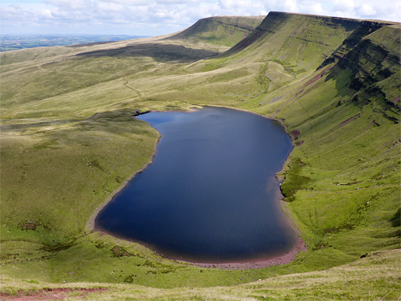
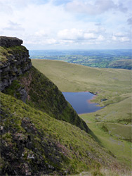
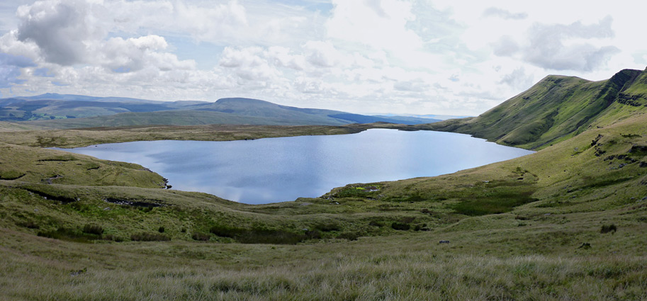
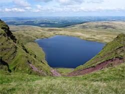
The Black Mountain (Y Mynydd Du) forms the western quarter of Brecon Beacons National Park, and as well as being the least visited and most isolated region of the preserve, also contains the most remote hill in Wales, in terms of the distance from a paved road - this is Tyle Garw, an otherwise unremarkable ridge alongside the upper reaches of the Afon Twrch. Most of the mountain is an elevated plateau, rather featureless, crossed by minor drainages and sprinkled with shake holes, ponds and small rocky outcrops, but mostly covered by grass and peat bogs, however the scenery is much more dramatic towards the north, as here, the land, having risen only gradually over several miles from the south, reaches a high point at Fan Brycheiniog, in the middle of a spectacular, six mile escarpment, dropping down very steeply on the far side by up to 700 feet. Nestled below are two large lakes (Llyn y Fan Fawr and Llyn y Fan Fach), the latter enclosed by the precipitous slopes on three sides. The cliffs and the lakes are relics of ancient glaciation, along with moraines, polished bedrock, and debris cones.
Llyn y Fan Fach, the closest and most photogenic lake, can be visited on a one-way walk of just 1.5 miles, while a hike to both, also incorporating the full length of the ridge, is 12 miles round trip from the eastern trailhead (described below), or slightly longer from the west. The mountains along the ridge are known generally as the Fans (fan being the Welsh for peak), or sometimes as the Carmarthen Fans, though only half of the escarpment is in Carmarthenshire - the eastern half is in Powys, including two major summits, the elongated Fan Hir and the better defined Fan Brycheiniog, though all summits hereabouts are flat-topped, grassy, and lack any distinct, rocky peaks. In Carmarthenshire the ridge continues to the summits of Picws Du and Wawn Lefrith.
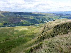
The lakes are pretty, and the lowlands have a few other features of note including ruins, waterfalls and small rock formations, but the ridge walk is the most spectacular section. The views extend south to the Gower Peninsula and the open sea, eastwards to Pen y Fan in the centre of the national park, and north to the mountains of central Wales. Despite this, some parts of the walk are a little monotonous as there is not so much of interest in the immediate surroundings; the main attractions are the overall landscape and the long-distance views.
The fans can be approached from the west, along a narrow road from Llanddeusant, which becomes a bumpy, gravel track that continues all the way to the lake; the public parking place is 1.3 miles before the end, from where the track follows the lake's exit stream (Afon Sawdde), past a fish farm about half way along, all the way at a constant though not too steep gradient. Another path leaves the road a little further back, climbing to the west end of the main ridge, and a 4 mile loop can be made by the descending to the lake and returning along the track. However, if walking the full loop, the eastern end offers somewhat easier access, starting along the A4067 just north of Glyntawe and the Dan yr Ogof caves - parking is available opposite the Tafarn-y-Garreg pub or in front of St John the Baptist church.
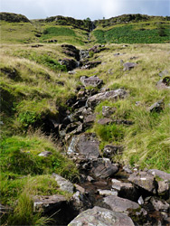
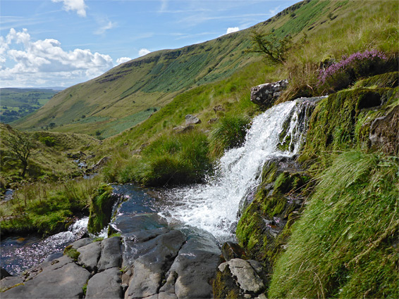
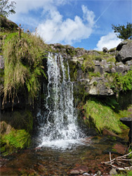
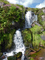
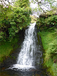
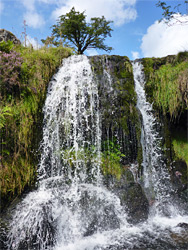
The path, part of the long distance Beacons Way, starts on the south side of the pub carpark - through a field, across the River Tawe on a footbridge, beside the river for a few hundred feet and along an ancient lane between stone walls to a style and fence marking the boundary between farmland and the open country above. A path to the west ascends to Allt Fach, at the southern end of the escarpment, and forms the final section of the loop, while the main route continues north, staying close to a tributary drainage, the Nant Tawe-Fechan, which initially flows through a shallow valley lined with trees then becomes open and less vegetated. The path moves away for a while, before coming close again and crossing to the far side of the drainage. Downstream of here, over a distance of about 700 feet, is a pretty sequence of about a dozen waterfalls, framed by ferns, heather and other plants, all quite easily viewed by a short diversion; the tallest drop is 20 feet.
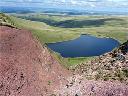
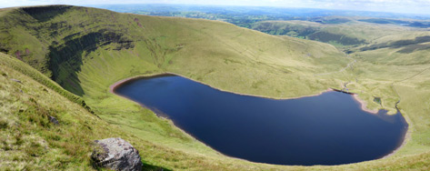
The stream divides near its upper end, the two branches separated by a long, low ridge named Fan Fechan, thought to be a moraine that formed alongside a narrow glacier; the path rises more steeply up to the ridgeline (see QTVR) and follows the crest northwards, beneath ever more dramatic slopes to the west, this the great escarpment below the elongated summit of Fan Hir. Eventually the trail crosses some grassy mounds and a low divide, and drops down slightly to the southern edge of Llyn y Fan Fawr (Great Peak Lake), at the start of its exit stream, Nant y Llyn. This lake, the most remote in the national park, is only slightly larger than its companion to the north and has a less spectacular setting, though is quieter and feels more isolated. A steep path climbs the slope above, following a faultline, to a gap in the escarpment named Bwlch y Giedd, useful if exploring just the northern or southern section of the ridge, while two other paths continue north, running along both sides of the lake. The continuation trail passes beneath the highest peak in the area, Fan Brycheiniog, and above a few rocky patches, then descends to a little valley (Gwal y Cadno, 'lair of the fox'), which contains the low wall remnants of an ancient three-room house, seemingly abandoned several centuries ago. The path proceeds around a promontory below Fan Foel, and across the slopes of Cefn Bryn y Fuwch, where the other lake first comes into (partial) view, one mile ahead. The route winds across the slopes around the edge of a basin below the cliffs of Bannau Sir Gaer, past another connecting route to the ridge above, while an alternative traverses the basin lower down, over sometimes boggy ground that harbours at least one pool, containing dark, tannin-stained water.
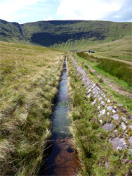
The next section of the trail follows a drainage (Afon Sychlwch) for a little way then veers left alongside a small aqueduct, or leat, that diverts some water from here into Llyn y Fan Fach (Small Peak Lake), 2,000 feet away. This lake is partly confined by a dam and its waters leave over a weir, next to an disused pumping house, but the rest of the surroundings are natural and pristine. The lake is backed by particularly dramatic and colorful cliffs, crossed by parallel, horizontal ledges, and split by vertical gullies, leading to debris chutes below, and most are covered with bright green grass and moss. A track heads north alongside the exit stream to the western trailhead near Llanddeusant, while a path ascends the steep slopes on the northwest side of the lake, later curving south to the ill-defined summit of Waun Lefrith (2,209 feet) at the western end of the escarpment, about half way along the 12 mile loop.
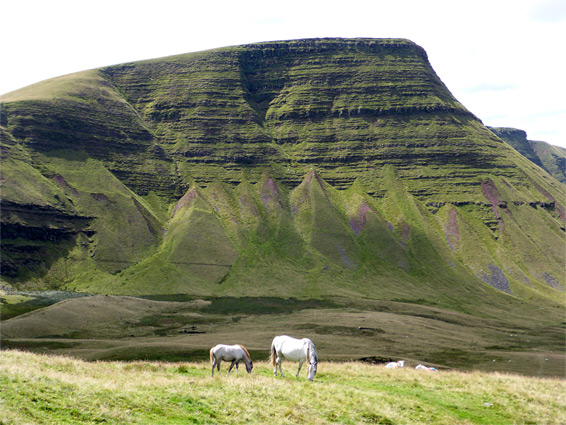
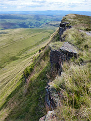
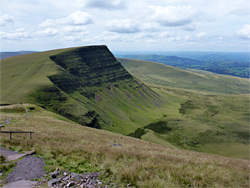
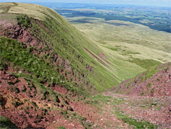
The ridgeline path leads east from Waun Lefrith, always staying close to the rim, initially above Llyn y Fan Fach. The exposed rocks are from the Plateau Beds member of the Old Red Sandstone formation, resistant strata that form most of the highest points of the Black Mountain, and are variously coloured in shades of grey or red; the latter colour is especially evident in some of the near vertical chutes down from the escarpment. After a brief descent, the path climbs again to 2,460 foot Picws Du followed by a sharper descent to a saddle between two drainages, before climbing again, veering northwards to the tip of Fan Foel, where both lakes are in view from (almost) the same point. A short walk further reaches the rocky summit of Fan Brycheiniog (2,633 feet), the highest point of the Black Mountain, and the fourth highest major summit in the national park; Llyn y Fan Fawr is directly below.
To the east, the trail now descends 300 feet over a relatively short distance to the pass at Bwlch y Giedd, where the main branch goes down even more steeply to the lake, and the onwards section, much less used, is level for a while, continuing due south all along the edge of Fan Hir then descending gradually in a series of flats and small slopes, past little changing surroundings for another 2 miles. Finally, it heads straight down a steeper on the east side of Allt Fach, at the far southern end of the ridge, back to the junction near the River Tawe, from where the parking area is just a few minutes further.