Varied collection of ancient monuments including the largest artificial hill in Europe (Silbury), a burial chamber, a stone-lined avenue, and the world's largest stone circle, in the village of Avebury
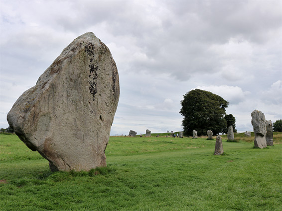
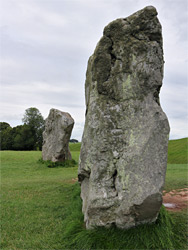
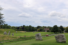
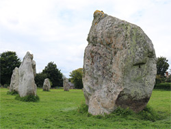
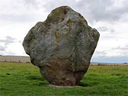
The Neolithic monuments at and around Avebury in Wiltshire comprise the northern section of the Stonehenge, Avebury and Associated Sites World Heritage Site, a varied group of stone and earthen structures dating from between 3700 BC and 1600 BC. At Stonehenge there is only one main visibly spectacular location, the elaborate circle, but Avebury has four major sites, most famous being the stone circle at the centre of the village - the largest such circle in the world, ringed by a high embankment and containing the remains of two smaller circles (each of which was larger than Stonehenge).
The other three notable locations are the largest artificial mound in Europe (Silbury Hill), a well preserved burial chamber (West Kennet Long Barrow), and West Kennet Avenue, a stone-lined corridor that linked the Avebury henge to another ancient stone circle (now known as the Sanctuary) that was mostly complete until destroyed by a farmer in 1723 and 1724. The position of the missing stones at this location are now marked by concrete blocks, making for a pleasingly symmetric though inevitably inauthentic spectacle. The Avebury section of the World Heritage Site also includes other earthworks, standing stones and barrows, extending over an area of five by three miles.
The great stone circle is by far the most popular location in the Avebury area, with hundreds of people visiting on a typical day, and the large nearby carpark often fills up completely. The other main sites could be seen by walking from here along country lanes or designated paths, for a loop of about ten miles, but smaller parking areas are available close to each location. Apart from the circle, West Kennet Avenue, West Kennet Long Barrow and Silbury Hill (described below), and the Sanctuary, three other significant places are the unexcavated, partly overgrown and rarely visited East Kennet Long Barrow, the two Long Stones, the only visible remnants of a second corridor of paired stones (Beckhampton Avenue) that extended west from the circle, and a group of ditches and earthworks on the small summit of Windmill Hill, one mile northwest of Avebury. All the sites are jointly managed by English Heritage and the National Trust, and entry is free, the only charge being for parking.
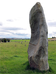
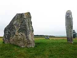
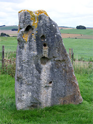
The National Trust-controlled parking area is on the southwest side of Avebury, from where the edge of the henge is 800 feet away, along a path past the local cricket ground. The circle is divided into four approximately equal quadrants by the two intersecting roads through the village - the A4361 north and south, and lesser routes east to west. Beyond the stones is a ditch and then an embankment, and the whole site is 1,500 feet in diameter. Excavations have revealed that when built the embankment rose 20 feet above the surroundings and the adjacent ditch was at least 30 feet deep, and nearly sheer-sided, creating an imposing and impassable set of defences. The outer circle originally contained 76 stones, of which 30 are still visible, and the position of another 15 are marked with concrete posts. Some of the standing stones have been re-erected in relatively recent times after lying prone for many centuries, and a further 20 are believed still to be buried, mostly towards the eastern half where very few remain above ground - the majority of the stones are in the southwest quadrant (11) and to the northwest (12). A walk of about one mile is required to see the whole circumference, of the main circle, and inspect the inner stones; four from the northern inner circle and five from the southern inner circle. Within these two circles are, respectively, The Cove, a pair of large stones at the centre, and the Z feature, a short line of much smaller stones whose origin is uncertain. The missing stones of all the circles were deliberately removed, by destruction or burying, a process that started in medieval times but accelerated into the 1700s, possibly in the belief that this would remove pagan influences. One method was to start a fire around a stone, eventually causing it to shatter: several resultant burn pits have been identified.
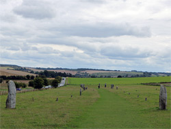
The southern entrance to the Avebury circle was linked to the other stone circle to the southeast (now the Sanctuary) by a 1.5 mile pathway lined by facing pairs of stones - West Kennet Avenue. The course is similar to that of the modern roads between these locations (B4003 and A4), the construction of which required removal of some of the stones, though as with the circle many more were purposefully destroyed. Out of the original total of about 200 stones (100 pairs), a few remain towards the south end, partly obscured by hedgerows, but the main section is to the north, where 28 stones can be seen, all but two on the west side of the road. The stones vary in height, from 4 to 13 feet, and have two general shapes - slender pinnacles with parallel sides, or flatter, approximately diamond-shaped blocks, narrow at the base and wider above, though to represent the male and female form. There is a small parking area at the south end of this section of the Avenue, while the north end is accessible from Avebury village.
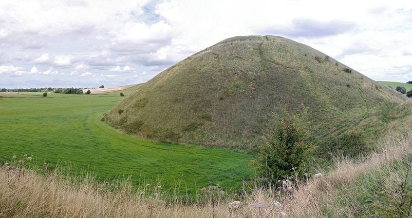
Silbury Hill is 129 feet high, conical in form and almost perfectly circular in outline, and 550 feet in diameter at the base, formed largely of chalk excavated from the near surroundings, and it was completed around 2350 BC, after several phases of construction extending over a number of generations. The hill is surrounded by a shallow ditch, liable to flood during wet weather. Investigations involving boring of shafts and tunnels, the earliest in 1776, have revealed no burials and only limited items of interest, and the purpose of this huge construction, which would have taken hundreds if not thousands of people to complete, is still unknown. Climbing the hill is no longer permitted but it can be viewed from below along a path on the east side, and from several areas alongside the main road (A4) that passes right by to the south; the main location is on the west side, and from here a 0.8 mile path links with the parking area at Avebury.
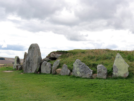
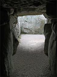
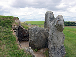
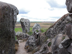
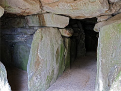
West Kennet Long Barrow, a well-preserved communal burial mound, lies in the middle of fields on the crest of a broad, low ridge, 0.4 miles south of a small parking area along the A4, just east of Silbury Hill, reached by a footpath. The place was constructed around 3700 BC, before both the hill and the Avebury circle, and was in use for over 1000 years. Five enclosures and a central passageway were built using many large and small stones, then all was covered by pure white chalk (now grassy earth), leaving a group of visible stones around the entrance, on the east side. The structure is 320 feet long and 90 feet wide at the east, tapering slightly to the west. The interior has been excavated on at least two occasions, and stabilised, allowing all areas to be entered. The remains of only around 50 individuals were recovered, though it is thought many more might have been removed or destroyed by earlier intrusions; a local doctor in the 18th century was reported to use human bones from the barrow as an ingredient in potions.