Seven mile section of Devon's Jurassic coast, extending into Dorset; remote sand and pebble beaches below lengthy cliffs, above which are overgrown landslips. Explorable by the coast path, or walking at sea level
Location
Between Seaton, at the mouth of the River Axe, and Lyme Regis
Walk
14 mile loop - out along the beach, back via the path
The coastal cliffs east of Axmouth and Seaton in southeast Devon are notable for extensive landslips, resulting from movement of relatively dense chalk and sandstone above unstable, impervious layers of clay, creating a jumbled band of gullies, ridges and escarpments, all of which have become thickly wooded over the last century. The corridor of uneven terrain is up to half a mile wide and extends for nearly seven miles, to the vicinity of Lyme Regis in Dorset, and all is protected as the Axmouth to Lyme Regis Undercliffs National Nature Reserve, also part of the East Devon Area of Outstanding Natural Beauty.
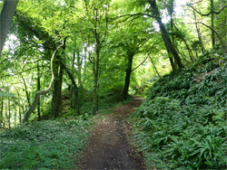
The coast path runs all the way through the reserve, generally out of sight of the English Channel due to tall trees (mostly ash and field maple) and the uneven land, and in the whole seven miles there is only one access point to the coastline, at Charton Bay about half way along. The woods of the reserve shelter a good variety of plant species and the whole area is noted for its interesting geology, though the lack of sea views and the up-and-down terrain make the walk along the coast path not necessarily so enjoyable.
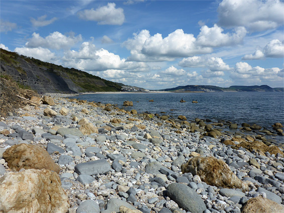
Much better, for scenery, is the coastline itself, below the cliffs, and this can be walked relatively easily, except perhaps around high tide. There are no significant obstacles, and for most of the distance the beaches are formed of firm boulders, coarse sand and exposed bedrock, with just a few stretches of loose pebbles. The cliffs vary in height, colour and amount of covering vegetation, and are crossed by small streams, sometimes forming pools and little cascades. Apart from the vicinity of Axmouth, at Charton Bay and especially near Lyme Regis, this section of the coast is very rarely visited, hence the beaches are completely unspoilt and litter-free, and quite pretty. Other features of interest include rock formations, tide pools, flat terraces containing ammonite fossils, the remains of a wrecked ship and a group of photogenic fallen trees, plus many wildflowers. A loop hike from Axmouth to Lyme Regis, along the beaches and back on the coast path, is about 14 miles, with the option of shortening this via the connection at Charton Bay.
Free parking is available along verges on the west side of the B3172 on the approach to Seaton, overlooking the estuary of the River Axe; the coast path begins on the opposite side, initially along Squire's Lane to the local golf course, while the beach is accessed via a short track alongside the lower end of the river. The hike can just as easily begin at the far end of the undercliffs, in Lyme Regis, though parking here is more crowded, and not free.
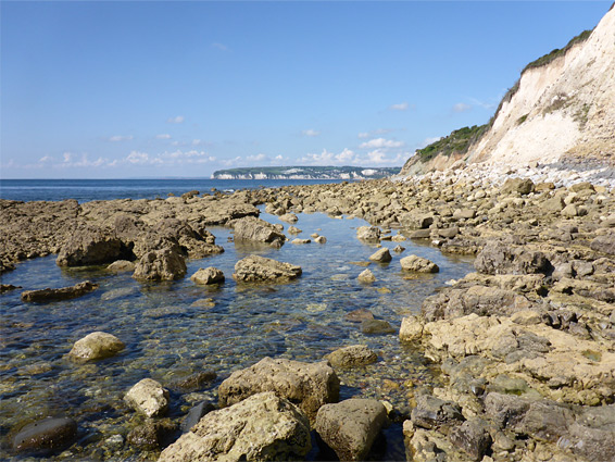
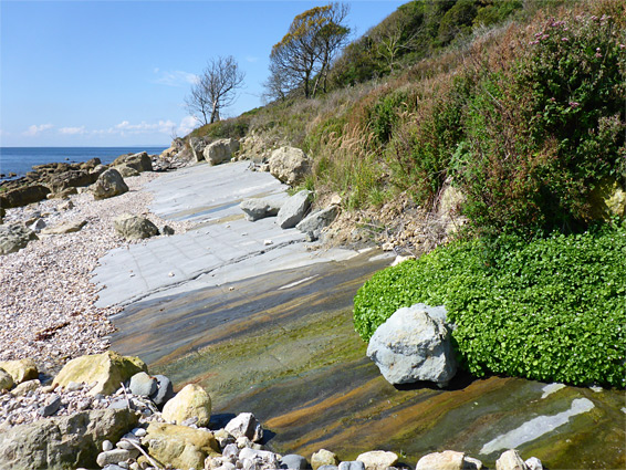
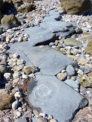
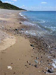
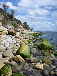
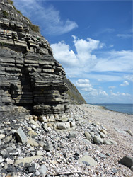
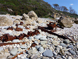
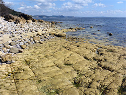
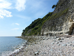
From the B3172 on the approach to Seaton, a track runs along the embankment on the east side of the River Axe, past a few buildings, and ends at the start of a one mile stretch of flint pebble beach, beneath the straight, thin-layered Haven Cliffs, formed of grey or reddish mudstones. A path climbs the bushy slopes at the near end of the pebbles, and a notice on a viewing platform gives information about the Undercliffs region, though the beach is not much frequented, apart perhaps from people taking advantage of its status as a naturist area. Walking along the beach is a little tiring owing to the shifting pebbles but becomes easier at the far side, at Culverhole Point, where the surface is covered by larger rocks and gravel, residue from an 1839 landslide. The next stretch has a mix of gravel and sand, now beneath steep slopes of white chalk, part of the Bindon Cliffs, and then the more extensive Dowlands Cliffs. The cliffs are steepest either side of a little promontory opposite the Corbin Rocks, a group of flat, brownish slabs bordered by pools at low tide; beyond is an area of more irregular boulders, composed of coarse-grained sandstone from the upper greensand layer, which overlies the blue lias bedrock. Amongst the boulders are an assortment of iron relics from some ancient shipwreck, including part of a propeller shaft. The blue lias is fully exposed on the far side, at a pericline; several curving, parallel layers, slightly inclined to form ridges, with a generally smooth surface and containing numerous ammonite fossils. Water from seeps trickles over the angled strata in several places, creating pretty patterns, lined with yellow and green algae. Around here the cliffs are temporarily replaced by gentle slopes, though thick undergrowth prevents any access from the coastal path, only about 300 feet inland.
Continuing east, the rocks underfoot are larger and firmer, making for easier walking, beneath more chalk cliffs and slopes, and past several more streams, one relatively large, flowing noisily over an unseen cascade beneath the vegetation. The coast curves slightly to the northeast, beneath the shorter Rousdon Cliffs and straightens out at the wide expanse of Charton Bay, which contains some sizeable sandy patches, especially at low tide, but is otherwise covered by small pebbles of chert and flint. The bay is accessible (on foot) from the only connection along the coast path between Axmouth and Lyme Regis, via a rough track from Stepps Road.
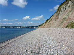
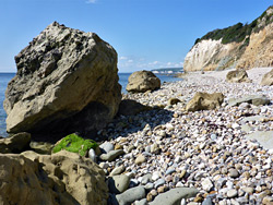
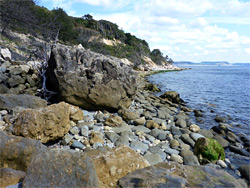
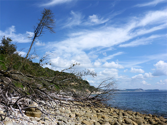
The east end of Charton Bay is bordered by more upper greensand boulders, the Humble Rocks, as the intertidal zone narrows somewhat, and landslips have resulted in bigger rocks and fallen trees lying across the beach, one of the most photogenic sections of this part of the coast. This is one of the regions that would be most difficult to pass around high tide. Inland are lengthy, overgrown slopes which give way to cliffs once more around Pinhay Bay, formed of grey layers of the blue lias formation, on top of the lighter white lias, which forms some wave-cut terraces, and also contains many fossils. Bands of strata curve seawards at Seven Rock Point, only properly visible around high tide, then round the next bend are more greyish cliffs, extending another half mile to Chippel Bay and Lyme Regis. The coast beyond is visible for a long way, all along Chesil Beach to the Isle of Portland. Fossils, including ammonites, are again much in evidence, and this section of the beach is often quite busy with people looking for good specimens. The harder, more resistant components of the blue lias (limestone) gradually fade away and descend below ground, leaving just crumbling, dark grey shales, and the vertical, layered cliffs give way to grassy slopes as the town approaches, while below, the pebbles and rocks are replaced by the sands of Monmouth Beach.
The coast path from Lyme Regis to Axmouth starts on the west side of the bowling green near Monmouth Beach; across a residential lane and steeply up beside a stream through a patch of trees, before veering west, over a field to a viewpoint of the sea. The trail proceeds through more grassy land, past a home and along a vehicle track to another house, originally a dairy, where the track ends and the continuation path enters the thick woodland of the Ware Cliffs, and for the next five miles there are very few views of the sea, only of the dense, jungle-like forest. Some stretches of the path are straight, flat or gently descending, through relatively open woods, while others are more undulating, crossing little ravines and ridges, hemmed in by closely-spaced trees. The surface is often uneven, due to roots and stones, and some patches stay muddy all year. A few paths branch off northwards near the start but for most of the way there are no junctions, and no access either to the beach or to the inland road, apart from at Charton Bay.
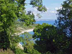
The woods of the Ware Cliffs to give way to the similarly dense forest enveloping the Pinhay Cliffs, suceeded by the Whitlands Cliffs and the Charton Cliff, and in the middle of this region is the junction with the vehicle track, from where a short path descends to Charton Bay. Overlooking the junction is a tall brick chimney, the only surviving component of a Victorian pumping station; another associated ruin, of an engineer's cottage, is passed a little way beyond. The next section of the path has one good viewpoint of the bay, admired from a bench, followed by another long straight through dark trees, all across the Rousdon Cliffs and the longer Dowlands Cliffs to the vicinity of Goat Island, a large patch of treeless grassland (originaly part of a crop field) that slumped downwards and seawards in 1839, and is surrounded by overgrown gullies on all sides. A much more recent landslip has closed part of the original coast path, below the island, and now the route bears right at a junction, climbs steeply, bends west again and crosses the island, which is managed as a floral chalk meadow, kept free of shrubs. The ground falls away vertically on the south side of the island, and the rim affords the best viewpoint on the whole path. To the west, the woodland, now less dense, resumes as the trail climbs over a little ridge, descends briefly into the end of The Chasm - the gap that opened on the north side of the landslip, then runs along a field a little way before turning inland, between two fields and alongside Axe Cliff golf course. The final section is down a bridalway, across part of the golf course and down Squire's Lane to the B3172.