Five mile section of Dorset's Jurassic Coast, including Charmouth, Stonebarrow Hill and Golden Cap, explorable via the coast path or walking at sea level
Location
Charmouth Road car park, Lyme Regis; DT7 3DR
Walk
12 miles, loop, along the coast path and back along the beach; various shorter walks possible
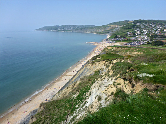
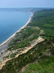
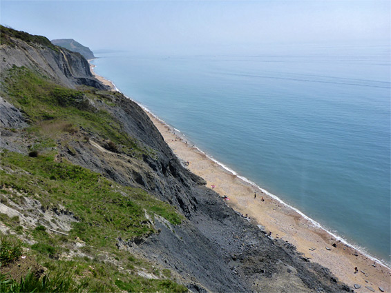
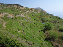
The five mile section of the Jurassic Coast from Lyme Regis east to Seatown in southwest Dorset is characterised by tall, unstable cliffs of the lias group, mostly composed of grey, clayish rocks, much susceptible to landslips, and generally not as photogenic as the cliffs to the west, to Axmouth and beyond, as they are harder and less homogenous, resulting in more interesting formations. In contrast, the coast path along the top of the cliffs is much more scenic, since the Axmouth section passes through several miles of thick woodland, out-of-sight of the sea, but to the east the land is largely treeless, a mix of farm fields and rough grassland, so the views are consistently spectacular.
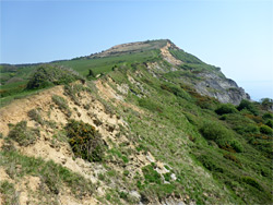
In two places (Stonebarrow Hill and Golden Cap), the land rises to incorporate summits of the harder, overlying greensand sandstone; at 627 feet the latter is the highest point along the southern English coast. The beaches below are almost all covered by pebbles, with just a few rocky areas - some of which are the results of landslips rather than in-situ exposures - plus patches of sand in the mile or so east of Charmouth, the other significant settlement in this stretch of the coast.
Because the rocks are soft, and frequently eroding, the beaches east of Lyme Regis are amongst the best locations on the Jurassic Coast for fossil hunting, in particular for ammonites, which are plentiful in most areas. But still most people who visit are here for traditional beach activities, and the three towns are often very busy, despite the relative lack of sand on the beaches. The other popular activity is the ascent of Golden Cap, usually from the east, starting at Seatown, a walk of one mile. The full length of the path from Seatown to Lyme Regis is 7 miles, staying close to the cliff edge for most of way to Charmouth, then turning inland, since the previous course, close to the shore, was lost in a landslide, in May 2008. Away from the three towns, the coast path is also accessible from several other places, including two parking areas along a minor road on the north side of Stonebarrow Hill, and in the vicinity of Golden Cap.
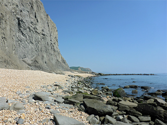
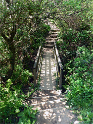
As is usually the case, the coast east of Lyme Regis can also be explored at sea level, with no significant obstructions except around high tide, when some scrambling over clayish landslip debris is required. However, the route passes below some particularly unstable cliffs, especially around Golden Cap, a mile west of Seatown, so walking at low tide is preferred, in order to keep a safe distance away. There are no recognised routes to the shoreline apart from at the three towns; the only other link used to be at St Gabriel's Mouth, the end of a small stream, but the steps that formed the lower section of the path were swept away by a landslide, not for the first time, in 2017.
The walk described below is along the coast path from Lyme Regis to Seatown, through Charmouth, returning all along the shoreline. There are many options for shorter trips, visiting just part of the area.
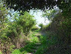
The best place to start the eastwards walk in Lyme Regis is the Charmouth Road car park, just north of the town centre, a generally less busy location than parking places closer to the shore. The coast path leaves the road just to the north, and before the 2008 landslide continued eastwards, climbing and following the cliff edge alongside the local golf course to Charmouth, but it is now open only a short distance, soon returning to another road, Timber Hill. This is followed northwards to a junction with the A3052, soon after which a path resumes, entering the golf course, crossing four fairways whilst passing over the brow of a hill, then descending quite steeply through a patch of shady conifer woodland, emerging to the A3052 once more, and continuing beside roads for the next mile, to the beach carpark in Charmouth. This rather unmemorable section of the coast path is 2.3 miles in length, compared with the original 1.7 miles.
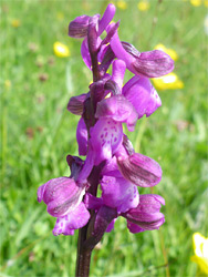
The eastwards path from the beach car park in Charmouth crosses the River Char on a footbridge and starts a climb up the grassy slopes of Stonebarrow Hill, briefly through a steep, bushy area then out to more meadows along the rim of Cain's Folly, a densely overgrown landslip, where the land reaches its high point, 486 feet. The hill is an elongated feature, stretching northeastwards for 1.5 miles, and most is owned by the National Trust, accessible from an inland path forking off near the cliff-side summit. The coast path continues by descending through a patch of scrub, across a field used by cattle and into a hay meadow where many green-winged orchids flower in spring, this just south of Westhay Farm. Beyond are two more cattle fields, as the path drops down to a crossing of a small stream (Westhay Water), then climbs once more, quite steeply, while veering northeast to avoid another relatively recent landslip at Ridge Cliff, followed by a more gentle descent to another bridge over a stream, Ridge Water.
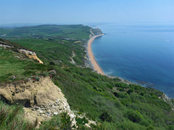
The path rises once more, over a field and round a patch of trees as the high ground of Golden Cap comes prominently into view ahead. The land is fairly level for a while, up to the stream that leads to St Gabriel's Mouth, just before which is the now closed path that once descended all the way to the beach. The main climb to Golden Cap is initially via steps, up an overgrown area, then mostly across fields, always close to the cliff edge, ending with a few switchbacks through rougher pasture. The views on a clear day extend 20 miles east to the Isle of Portland, and a long way west, beyond Lyme Regis. Directly below, though out of sight, are a series of benches and precipitous slopes (Shore Cliff and Wear Cliffs) shaped by landslips, angling down very steeply to the shoreline, where low tides reveal two rock-lined lagoons, The Cove and Little Cann, visible directly beneath the summit; the rocks result from ancient landslides. The path east of Golden Cap is always busier than that to the west, used by people walking the short distance from Seatown, though the descent is not so interesting, since the trail generally stays away from the cliff edge - it crosses several fields, past a patch trees and underneath the wooded summit of Langdon Hill to the north before meeting the narrow road (Sea Hill Lane) that leads down to Seatown village.
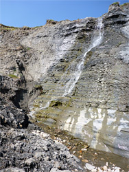
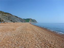
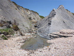
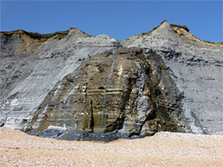
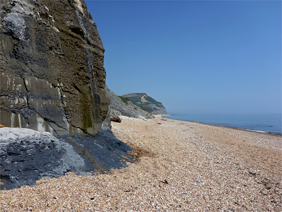
The beach at Seatown is entirely formed of light brown pebbles, mostly flint and chert, and this extends westwards for 0.6 miles, beneath grey cliffs of increasing height, formed of the lower and middle lias strata. The cliffs become more dramatic, vertical rather than sloping, at the end of this section, where the pebbles are replaced by jumbled boulders and clayish mounds, result of landslips from the cliffs beneath Golden Cap. These extend a few hundred feet, giving way to a small, pretty beach with some sand, followed, after a rocky spur, by a second beach; at low tide both slope down to the rock-lined lagoons which are visible from Golden Cap, over 600 feet above. The cliff behind is the most potentially dangerous spot along this part of the coast, being very tall and liable to shed rocks at any time. Beyond the western beach is a slightly longer patch of big boulders and fallen debris, plus some rocky outcrops, before an unbroken strip of pebbles, lacking any other obstacles, that continues for 2.4 miles all the way to Charmouth. Initially this beach is quite steeply sloping, making for tiring walking over the shifting pebbles, but the gradient gradually lessens, the beach widens and patches of sand start to appear, especially at low tide. All this segment is bordered by steep, grey, rather featureless slopes, with very little plant life, and the only significant landmarks are various streams that flow down; first is St Gabriel's Water, running through a V-shaped ravine, with the remnants of the old steps to one side. Two other named drainages are Ridge Water and Westhay Water, both forming photogenic cascades down the lowest section of the cliffs; the latter fans out around all sides of a protruding mound. After here, as the cliffs run beneath the lengthy landslip of Cain's Folly, the beach becomes busier once more, with people walking from Charmouth.
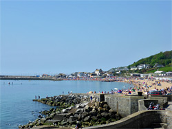
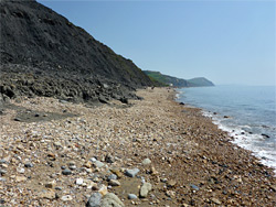
The beach west of Charmouth is also mostly composed of pebbles, beneath a particularly dark section of cliff known as Black Ven - formed of blue lias shale and limestone, and a plentiful source of ammonite fossils. After 0.4 miles the coast bends to the southwest, and more rocks are exposed, at low tide, bordered now by clayish detritus from recent landslips. Past here are alternating patches of pebbles and fallen boulders, not especially interesting, and finally a longer pebbly section, extending to the end of the seawall and promenade on the east side of Lyme Regis, linked by a short path to the car park along Charmouth Road. The wall is a relatively recent installation, built to protect houses on the hill above, to stop the landslides which have affected the area to the east, below the golf course.