Spectacular, three mile section of the north Devon coast, with dense woodland sloping steeply down to remote beaches and eroded rock formations. Explorable via the coast path or (at low tide) by walking at sea level
The three miles of the north Devon coast between Glenthorne Beach and Foreland Point in Exmoor National Park is typically remote, and rarely accessed, since the land slopes up very sharply, reaching heights of over one thousand feet just a quarter of a mile inland, generally too steep for footpaths. The coast can still be followed relatively easy at sea level, however, during the few hours either side of low tide, as there are no major obstacles, unlike the stretch beyond Lynmouth, three miles further west, where in many places the cliffs drop down to deep water even at the lowest tide, so the coast can in general only be seen along paths high above.
The sheer cliffs also surround Foreland Point, a prominent headland, also the northernmost part of the Devon Coast, but to the east there extends a long strip of pebbles and boulders below the cliffs and wooded slopes, all the way to Porlock in Somerset, and while a walk along this whole distance would be rather long for one day, the hike can be tackled in two parts, starting or finishing about half way along at Glenthorne Beach, the only other place hereabouts where the shore is accessed by a marked path. Old maps show several more shoreline paths leading to the beaches to the west, but these are no longer evident at sea level, and the next official access point in this direction is at Lynmouth.
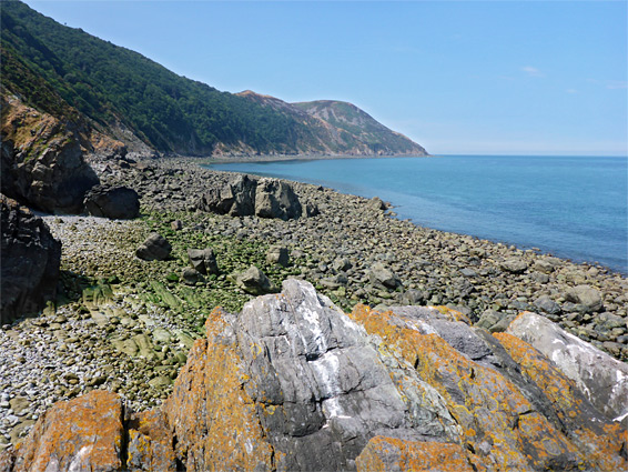
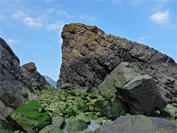
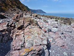
The walk from Glenthorne Beach to Foreland Point encounters numerous photogenic rock formations, eroded into the reddish-green, thin-layered sandstone of the Hangman formation, strata of which are inclined by up to 90 degrees. Two named features are Giant's Rib, a sea arch, and Sir Robert's Chair, a small stack; there are also several more arches, half a dozen cliff-side streams forming cascades and waterfalls, a number of short caves and many huge fallen rocks, but mostly just jumbled boulders and extensive pebble banks - similar to the other stretch, Porlock to Glenthorne Beach.
There are no significant obstructions, around low tide, though some scrambling is required at the far western end, to climb a steep slope below the lighthouse at Foreland Point. This may prove difficult for some people. The round-trip distance, west along the beach and back along the coast path is 8.5 miles, involving up to 1,130 feet of elevation change, and typically taking five hours or more.
The loop hike could begin from the vicinity of Foreland Point, parking at Barna Barrow on the A39, near Countisbury, or perhaps along the narrow road to the Foreland Lighthouse (possibly private). The hike described below though begins in the east, near Glenthorne Beach, for which the start point is the County Gate Car Park, also along the A39; a free facility right on the border between Devon and Somerset. The park has good views south, across the valley of the East Lyn River, while a minor summit (Cosgate Hill) to the west overlooks the coast.
Glenthorne Beach
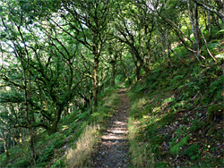
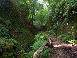
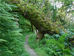
One of two connecting routes to the coast path in the vicinity of County Gate leaves from the far side of the road, just north of the carpark entrance, curving round to the west while descending a wooded slope, to the junction in a shallow valley, signed Glenthorne Beach right (east). In this direction, the coast path is followed for 1,500 feet, past a spring and pool, to another intersection, with an unsigned track on the left. This leads steeply down, over a stream and on to a gate marking the start of private land, the track continuing a short distance to Home Farm, on the floor of a sheltered valley (Coscombe). A path forks right just before, traversing the hillside above a field, later descending through a patch of closely-spaced pine trees to a third junction, signed Yenworthy Combe right, Glenthorne Beach left. A short walk down this latter branch, through the enclosed, shadowy, lower section of the combe, leads to the beach, overlooked at this point by the ruins of a stone boathouse and limekiln.
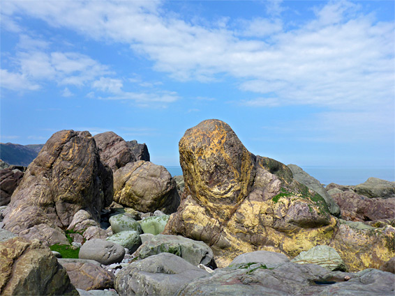
Turning west, the pebble beach extends another 700 feet, beneath low cliffs, above which is the spectacular mansion of Glenthorne, recently up for sale. Towards the far side the dry cliffs are interrupted by a small but pretty waterfall, cascading directly onto the beach, then soon after the pebbles give way to rounded boulders and other, more angular rocks. One particularly large, light coloured block has an official name, Yellow Hammer Rock, and is followed shortly after by the natural arch of Giant's Rib, a slanted cavity beneath a broad, sloping sandstone fin. Next is a grassier section of the cliffs, with trees above, leading to a rockfall area and a minor headland, beyond which Foreland Point is visible for the first time. More shapely, photogenic rocks are strewn across the intertidal zone, one coloured an unusually rich shade of yellow. The next major promontory is Desolation Point, below Wingate Wood, and the near side is formed by a near-vertical gully at the lower end of Wingate Combe, containing a permanent stream forming a sequence of waterfalls. The point is the second place passable only around low tide, the first being Giant's Rib.
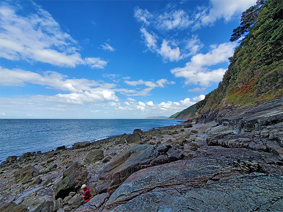
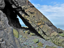
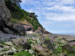
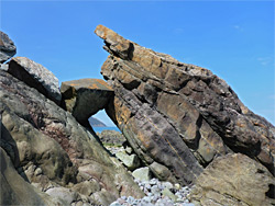
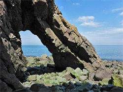
The north side of Desolation Point slopes precipitously down to a huge, detached rock, the largest sea stack along this section of the coast, opposite another fin and a longer sea cave with a deep pool at the base, opening out on the west side to a little pebble bay, containing the smaller formation of Sir Robert's Chair. After here the coast for some distance is lined by a mix of layered cliffs, scree slopes, smaller ribs and numerous large boulders. Another, smaller waterfall is formed by Pudleep Gurt, trickling down from the deep woodland above, and later are three more, Swannel Combe, Chubhill Combe and Kipscombe Combe, these above Countisbury Cove, in the middle of a half mile stretch with fewer big rocks, and more pebbles, plus some sandy patches at low tide; generally lacking any dramatic formations except near the west end, just east of another drainage, Coddow Combe, where there is another (unnamed) sandstone arch, the best in the area. The stream in Coddow Combe also forms an impressive cascade, named Shoot of Water, tumbling down high, mossy cliffs, a short distance before Foreland Point. One other feature of note along Countisbury Cove is the ruins of an limekiln; several stone structures, partially collapsed, on the edge of a cliff a little way above the beach.
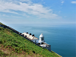
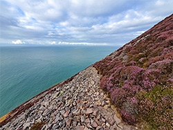
At Foreland Point the inclined sandstone strata, before mostly parallel to the land, become more perpendicular, creating vertical fins and narrow gullies, some extending inwards to caves, and making the coast much harder to traverse, even at low tide. The climb from the beach, the start of which may not be obvious, is relatively short but steep, straight up the sloping ridge on the near side of the point, opposite a jagged sea stack, Goat Rock. Bare sandstone soon gives way to short grass and then bracken and brambles, as the gradient gradually lessens. A rope may be left in place to assist in the most difficult section, at the start. The ridge leads up to a viewpoint on the road to Lynmouth Foreland Lighthouse, a white-painted structure built in 1900, attached to a cottage that is now owned by the National Trust, and operated as a holiday rental. The lighthouse is still in operation, fully automatic since 1994.
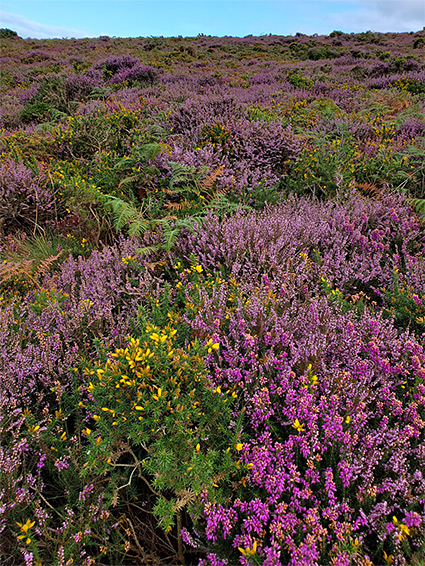
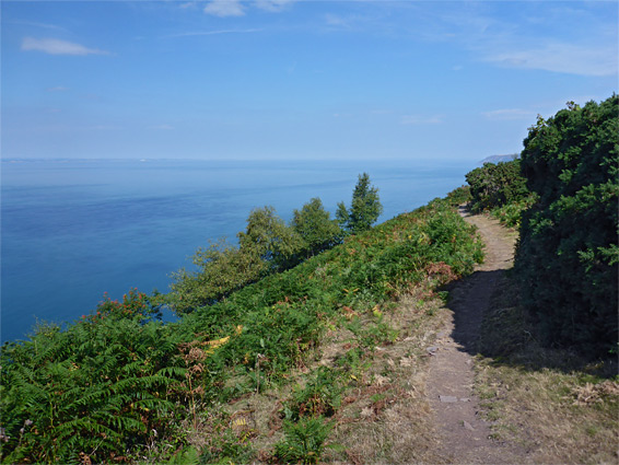
From the lighthouse, the shortest route back to the start of the walk is initially along the road, but there is a worthwhile diversion along a path to the southwest, looping all around Foreland Point and rejoining the road a little way uphill. The trail, an alternative alignment of the coast path, is narrow, and not advisable in rough weather owing to its exposure and the very steep slopes below. It climbs steadily, sometimes crossing scree, but mostly a mix of heather, bracken and gorse, while giving spectacular views of the coast, to the east at the start, then later to the west, towards Lynmouth, 2 miles away. After gaining 450 feet it intersects the main coast path, which to the east follows below the summit of the point and crosses the upper reaches of Coddow Combe before descending to the lighthouse road, while to the west is the next section, 2.5 miles to Lynmouth
The eastwards coast path follows the lighthouse road a short distance, up to a junction on the outside of a tight end, and continues on another, unpaved track, one that leads to a secluded cottage (Rodney's) in the thick woods of Kipscombe Enclosure, originally the accommodation for operators of the limekiln above Countisbury Cove. A gate across the track and a sign mark the edge of the private land; the coast path forks off to the right shortly before, and is generally level, crossing the upper reaches of the enclosure, over Chubhill Combe (usually dry) then the shorter Chubhill Wood to Swannel Combe, containing a stream. Next is Doctor's Wood, and another watery ravine, Pudleep Gurt, beyond which the path comes closer to the shore, rises a little and enters a grassy, treeless area, one of the few places where the sea is properly in view. One junction here is with a connecting path south to Countisbury Common. The coast path descends again, returning to the woods and crossing another stream, in Desolation Combe, and soon after reaches Wingate Combe, and another junction. The coast path is straight on, staying in the forest while rounding a headland to the Glenthorne area, while the other route offers a short-cut back to the County Gate car park, up the combe. It veers up the eastern fork of the valley and emerges to a field on the west side of Old Barrow Hill, then leads through a short patch of pine trees and across a field frequented by sheep. Nearby is Old Barrow, the low, circular earthworks from a Roman fort. The final section of the walk is through two more fields, along part of a path from the fort, and finally on another short path that parallels the A39, back to the initial junction.