West of Lynmouth, the north Devon coast is largely inaccessible at sea level, even more so than to the east, as far as Minehead, in Somerset; this section, while still cliff-bound, does have long, thin, mostly stony beaches at the foot of the steep slopes, but beyond Lynmouth, the base of the cliffs are in general submerged even at low tide, and hence the coastal path is the only way to explore this area.
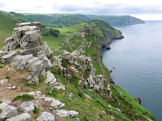
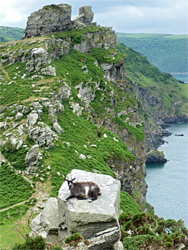
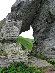
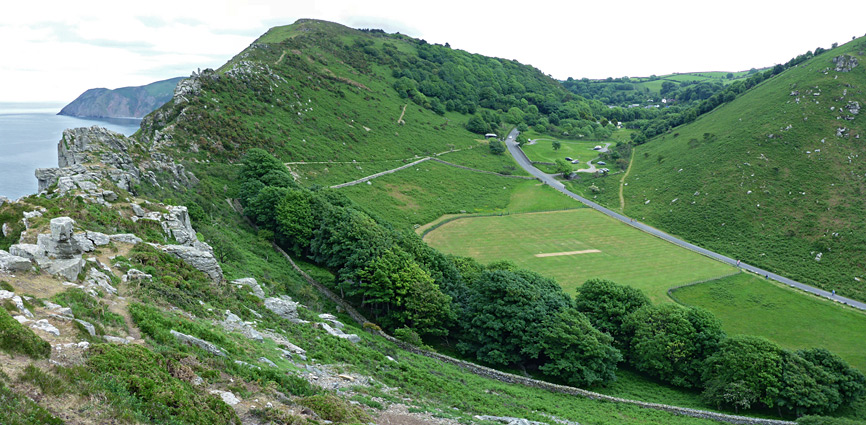
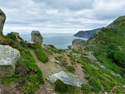
One of the more photogenic and unusual places hereabouts is Valley of Rocks, a relatively shallow ravine less than a mile long that runs parallel to the coast just inland, thought to be a former course of the lower end of the East Lyn River, which now joins the English Channel in the centre of Lynmouth. The valley is separated from the sea-facing cliffs by a narrow ridge topped by blocky, greyish, thin-layered sandstone and slate of the Lynton Formation, eroded into unusual forms. The south side of the valley is formed of a less-steep ridge, still with a few rocky exposures, while the floor is covered in grass and wildflowers, sloping gently down to a gap in the cliffs above Wringcliff Bay, a small sandy inlet. The valley is crossed by several paths, some linking with the main coast path, on the north side of the sandstone ridge. A little off-trail hiking is needed to see all the formations, which extend for half a mile. The rocky, gorse- and fern-covered slopes below are home to plenty of flowering plants in the spring and summer, and also to a small herd of wild goats.
More of the coast can be seen by a longer hike, on the coastal path, part of which runs along a little-used road; over a ridge, past the Christian retreat of Lee Abbey to the next inlet, Lee Bay, then into extensive woodland and down to the larger Woody Bay, lined by a narrow belt of rocks and sand. The shortest one-way distance to here from Valley of Rocks is 3.3 miles. Once past the valley, the sea is viewable only at a few places, being hidden by trees or intermediate land elsewhere.
Valley of Rocks is reached via a steep route west of Lynmouth; Castle Hill and Lee Road, initially climbing 500 feet in half a mile, then passing a residential area and a low, partly wooded saddle, after which the rocks first come into view. There are several metered parking areas, and a cafe, before the road reaches a roundabout, at the end of the most used part, as beyond, a lesser road continues through a gate that marks the boundary of the private estate of the abbey, still accessible to non-guest vehicles upon payment of a £2 toll. Pedestrians do not have to pay. The coast path follows the road for the next 2 miles until a trail forks off, descending towards Woody Bay, while the road heads inland. Along this part of the road is one other parking area, at Lee Bay, beside a holiday cottage, but after here there are virtually no other parking places, so this area is best accessed on foot.
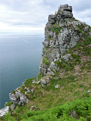
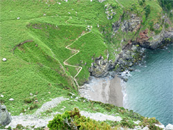
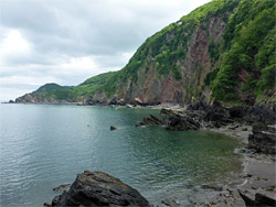
Starting from easternmost parking area in the valley, the main path traverses the hillside opposite, climbing gently to a gap (Middle Gate) near the east end of the line of sandstone formations that form the dramatic crest on the north side of the valley, then descends the far side a short distance to the coast path, which here crosses a steep, grassy slope known as North Walk. To the west, the path stays at the base of the ridge before moving back to the south side at the next significant gap, continuing a little way further to the road. Close-up views of the rocks can be obtained by walking westwards along the ridge from Middle Gate, over a succession of little gullies, flat rocks and jagged pinnacles, up to a high point (Rugged Jack) and then down to the path, continuing up the far side to the final section of the ridge which is centred on Castle Rock, another prominent peak topped by more huge boulders, some of which form an angular arch, framing a patch of the sea far below. This area, and the slopes below Rugged Jack, seem to be the usual locations of the goat herd. A slightly longer and more difficult descent leads back down towards the road, and to a short, switchbacking spur path to the adjacent beach, Wringcliff Bay, a strip of sand between tall cliffs, about 400 feet wide at low tide.
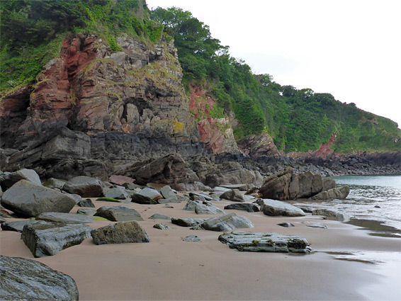
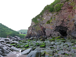
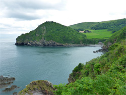
After the turn-off to Wringcliff Bay, the coast path continues close to the cliff edge for a little way before turning south at a private gate and meeting the road again, at the east edge of the Lee Abbey estate, beside an elegant stone gatehouse, which adjoins the Beacon Outdoor Activity Centre. The road moves inland, and the adjacent section of the coast is privately owned, out-of-bounds to the public; the next accessible part is just over half a mile further, past the abbey - a grand-looking building built in the 1850s - to the cottage at Lee Bay, location of the other parking area. Here, a short road descends to the sea and to a sheltered, sand and gravel beach lined by extensive, slippery rocks at low tide, backed by tall cliffs, mostly coloured grey but enlivened some patches of red. Low water levels allow some of the neighbouring coast to be explored, westwards to the next promontory, Crock Point, and northeast to Jennifried's Cove and the impassible Duty Point.
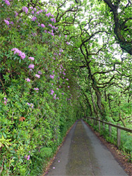
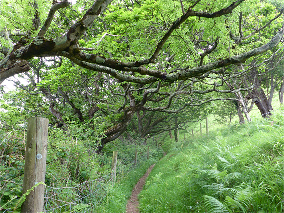
West of the cottage at the mouth of Lee Bay, the road narrows further and enters wooded land, moving out-of-sight of the coast once more. The most direct route of the coastal trail stays on the road, though an alternative, longer path forks off to the northwest, descending through the trees, then across a field to the very edge of the sheer cliffs above Crock Point, which can be seen though not easily reached owing to the vertical rocks below. The path continues along the west edge of the field and re-enters the trees (Crock Pits Wood) before climbing and meeting the road. This soon passes a junction with a road from the south, followed by an isolated house, after which it enters a pretty, straight corridor; to one side is a vertical slope covered with pink-flowered rhododendron bushes, while the branches of the enveloping trees arch down the far side, to form a tunnel.
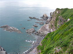
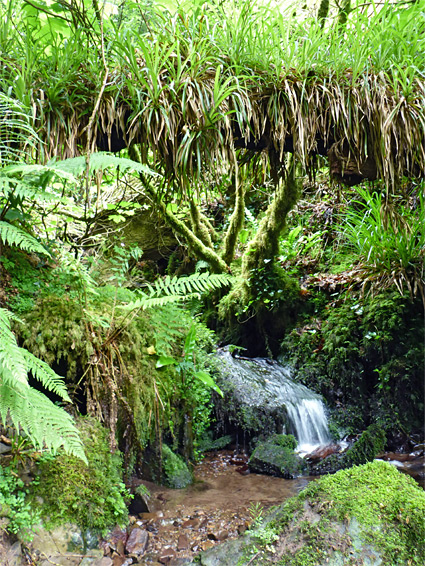
The coast path leaves the road a few hundred yards further, curving in and out of a wide valley completely covered by tall trees, crossing a stream (Hanging Water) just below a small but pretty cascade between fern-covered boulders, and on to the tiny community of Woody Bay, which consists of around a half a dozen large houses, deep in the forest. The bay itself is half a mile further, down a zig-zagging road (no public vehicles allowed) that stays within the woods until near the end, where it emerges to a rocky spur above the foundations of a Victorian pier, and finally down some steps to the beach. The stream crossed earlier tumbles to the beach over a 20 foot waterfall. To the east, nearly a mile is accessible at low tide, back towards Crock Point, though most of the few people that come here stay near the entrance path, on the west side. After Woody Bay, the next 1.5 miles of the coast path runs through more dense woodland followed by open slopes, then descends to the next major landmark, the National Trust-owned Heddon's Valley.