A famous sea arch and a circular cove, part of a varied, geologically complex, 2 mile section of the coast that also has headlands, sandy beaches, chalk cliffs and other eroded rock formations
Location
West Lulworth; BH20 5RQ
Walk
5 miles, loop, between Lulworth Cove and the promontory of Bat's Head; along the beaches and back along the clifftops
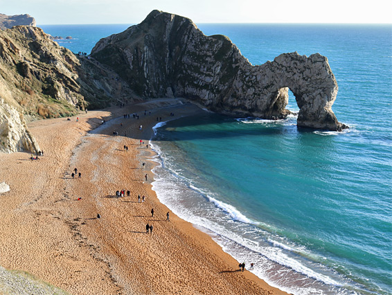
The most famous section of Dorset's Jurassic Coast is the 2 miles near the little village of West Lulworth, as this includes two very photogenic features; the near-circular inlet of Lulworth Cove and the great sea arch of Durdle Door. Also along this relatively short stretch are Stair Hole, a smaller cove lined by extravagantly-folded strata, a fine viewpoint on Dungy Head, a sea stack and a small arch at Bat's Head, a semi-submerged reef (Man-o-War), and lengthy beaches of golden sand beneath vertical cliffs of white chalk.
The variety of features is a consequence of the complex geology; most of the land in this part of the county is underlain by the chalk but some of the most southerly points are composed of more resistant limestone, separated by a narrow, softer band of reddish marl and sandstone; it is the limestone which forms the arch, the thin promontories at the entrance to the cove, and the offshore rocks. The cove is said to be the most visited geological landmark in Britain.
Lulworth Cove is 800 feet from a large carpark along the road from West Lulworth, while Durdle Door is one mile west, or just less than half a mile from a smaller alternative parking area beside a large caravan site. However, a better way to see these two features from all angles, and visit more of the surrounding coastline, is via a loop of five miles - to the cove and along the shoreline to a promontory on the east side, back west to the viewpoint on Dungy Head, then down to the sands of St Oswald's Bay, while coming close to the offshore rocks of Man-o-War, which shelter another pretty cove. Next is a short climb over a ridge and a descent to Durdle Door, followed by a walk on a second long beach framed by chalk cliffs, passing beneath the highpoint of Swyre Head to the sheer-walled promontory of Bat's Head. The return route is back along the beach a short distance, up a short, steep gully then along the top of the cliffs to the car park.
This section of the coast is part of the Lulworth Estate, which is owned by the Weld family, and centred on a fortified mansion, Lulworth Castle, built in the early 17th century. The estate operates a large pay-and-display carpark on the south side of West Lulworth village, from where most hikes begin.
Adjacent Areas
The coast west of Bat's Head, which is inaccessible from the east at beach level, is little changing for another mile, while the stretch east of Lulworth Cove also has less to see, and is partly restricted (contained within an MOD range), hence the 2 miles in between is the usually explored section, if starting from West Lulworth. The next-nearest scenic stretches are at Mupe Bay, Workbarrow Bay and Brandy Bay to the east, and Ringstead Bay and White Nothe to the west, and these may be explored by similar-length loop hikes starting at Tyneham Village and Ringstead respectively.
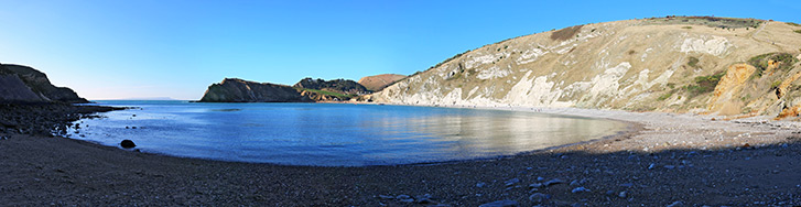
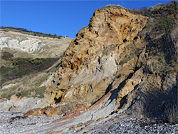
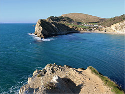
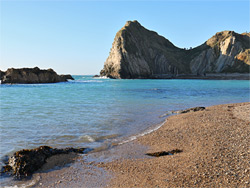
The closest site to the main carpark is Lulworth Cove, reached after a five minute walk down the road, which ends at a boat shed and cafe overlooking the sea. A cove is a small inlet with a narrow entrance, and the feature at Lulworth is one of the most famous in the country; perfectly symmetrical in outline, surrounded by interesting rock formations and filled with deep blue water. The north edge of the cove is bordered by tall cliffs of white chalk (mostly covered with grass), above a beach of large, loose pebbles that are a little difficult to walk along. The chalk is hard, and resistant to erosion, but the rocks to the south - marl and sandstone of the Wealden Supergroup - are much softer hence the sides of the cove have eroded more readily, to the west and east. The seaward side of the bay is formed of Purbeck limestone, somewhat harder, while beyond is a layer of Portland stone that is even more resistant, hence this has eroded the least, and forms the 400 foot-wide opening of the basin, which internally is 1,400 feet across.
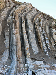
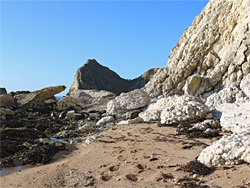
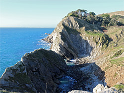
The best view of the bay is obtained by walking east then south along the beach, passing beneath the chalk cliffs and some colourful sandstone outcrops, followed by a short climb to the top of the bluffs; a path winds up the slopes and leads to an overlook right at the entrance to the cove, on a promontory known as East Horn, or East Point. Another path continues east along the cliffs for a few hundred feet to a fence marking the boundary of the MOD land, to which public access is allowed on most weekends, and major public holidays. The Lulworth loop hike continues by retracing steps to the west side of the cove then climbing a path to the top of the western promontory, though unlike that to the east, most of this is closed due to steep cliffs and unstable slopes, however there is a good viewpoint on top of the ridge - east across the cove and west to Stair Hole. Here, the sea has only relatively recently formed a breach in the outer Portland stone and has begun the slow erosion of the Purbeck limestone beyond; the waters have not quite penetrated to the softer sandstone just inland. The Portland ridge contains two small arches beside the main opening, and the rocks at either side to the north are notable for the extreme buckling of the strata, one section being known as the Lulworth Crumple. Again, due to potentially dangerous ground, all of the Stair Hole inlet is fenced off, viewable only from above, though it may be entered if approaching by boat.
Dungy Head, St Oswald's Bay, Man-o-War Cove and Durdle Door
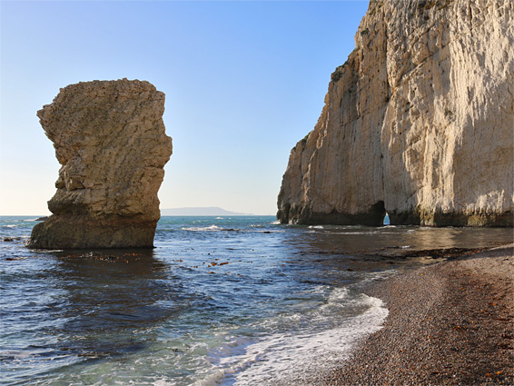
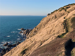
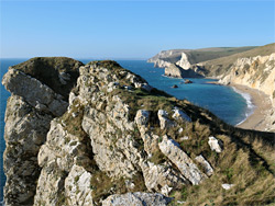
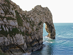
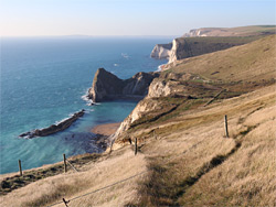
The next stage of the hike is along a path heading back to the car park, but then turning left just before, along a dead end residential street (Britwell Drive) for a few hundred yards and up a lesser-used path that climbs through a patch of woodland to the brink of the steep, seawards-facing slopes. The path proceeds westwards to a high point, Dungy Head, which affords fine views over the inaccessible, boulder-strewn coastline below and the sands of St Oswald's Bay to the west, these reached by a short, steep descent down a grassy slope. It is then an easy walk of 0.7 miles along the beach, round a little promontory (possibly submerged at high tide) to a semi-enclosed inlet, Man-o-War Cove, named after a narrow reef just offshore, composed of Portland stone, and probably resembling Lulworth Cove many millennia ago, when the reef was still connected to the shore. More twisted strata lie ahead on the far side of the cove, extending out under the sea. The land to the south rises to a sheer-sided headland, the westwards projection of which terminates in Durdle Door, and the arch is sighted for the first time after a short climb over the connecting ridge. Some people only see the arch from the top, but it is easy to climb down to the adjacent beach for a closer view. The arch spans deep water, even at low tide, so it is there is no chance to view it close up nor from any other directions (owing to the inaccessible slopes above) - only from the north and west.
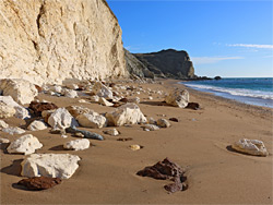
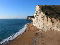
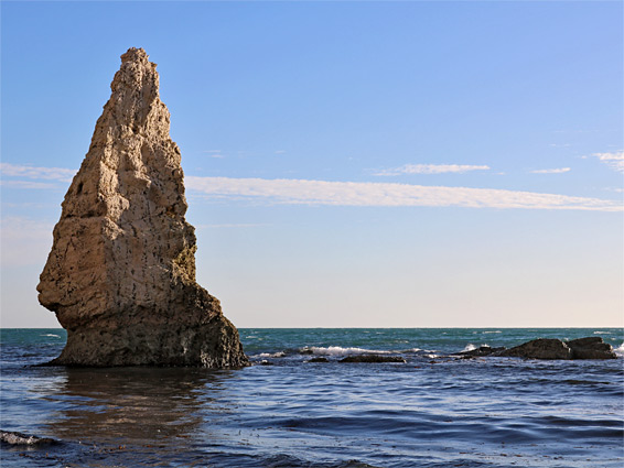
From Durdle Door to the next (impassable) headland, Bat's Point, is another 0.6 miles, along a generally wider sandy beach all beneath sheer cliffs of white chalk, embedded with lines of dark flint of modules at regular intervals. The cliffs start quite high, decrease to a low point along a shallow gulley and rise again to Swyre Head, 322 feet above the shoreline. The beach ends at the base of more white cliffs, projecting southwards, again extending well beyond the low water mark so this point is never passable. Bat's Hole is a small opening at the foot of the cliffs, while Butter Rock is a shapely sea stack close by, also composed of Portland stone, undercut at one side to create an unusual outline. From the headland it is 1.6 miles back to the parking area at West Lulworth, and one option is to walk the short distance back to the gully along the cliffs, climb a short steep ravine, aided by a rope which seems permanently installed, then walk the rest of the way on a trail along or close to the edge of the cliffs, for good, elevated views of Durdle Door and Man-o-War Cove. The final section of the path moves inland, descending a shallow valley to the parking area.