Five miles of the Somerset coast, within Exmoor National Park; rarely seen beaches and eroded sandstone formations below steep cliffs and extensive ancient woodland
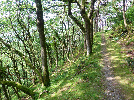
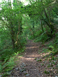
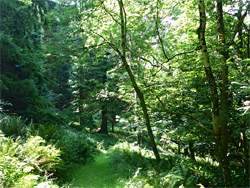
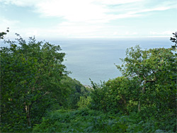
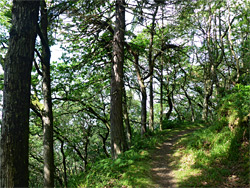
The Bristol Channel shoreline west of Porlock in west Somerset is typical of most of the Exmoor coast, being formed of cliffs and steep slopes, rising a thousand feet or more just a mile or two inland. The lower hillsides are mostly covered by a broad band of dense, ancient, oak woodland, the most extensive coastal forest in the UK, crossed by various paths at different levels, winding through little ravines and traversing lengthy straight sections. The official coast path runs generally across the top of the hills and above the trees, along vehicle tracks, so provides grand views of the distant sea, while the woodland routes have only brief glimpses of the Channel though are more atmospheric, and less used. None of the paths come within sight of the actual shoreline, however.
The trails are the usual way to follow the shore, but as is the case for the majority of the Exmoor coast, it can also be explored at sea level - a strip of boulders, pebbles, rocky outcrops and occasional patches of sand extends northwards for up to 400 feet at low tide, enabling fairly straightforward walking, with no great obstacles, at least as far as the vicinity of Glenthorne Beach, 5 miles from Porlock Weir; beyond are some larger rocky areas and promontories that are passable only when the tide is fully out. The one potential obstacle before this is a protruding cliff named Ivy Stone, which can be passed without climbing or wading for around three hours either side of low water.
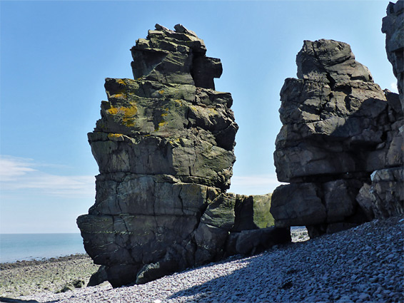
In addition to the long stretches of remote, pebble beaches, and the dark, sometimes twisted strata of the steep hillsides, the walk also encounters streams, waterfalls, ruined buildings, caves, sea stacks and plenty of summer wildflowers, along a rarely-seen section of the coast. West of Porlock Weir, the next access to the beaches from the paths above is via two overgrown trails, not obvious at sea level, after 3.2 and 3.6 miles, while beyond is the only slightly more used path to Glenthorne Beach (4.5 miles). The round trip, a little way beyond this point to a large protruding fin named a Giant's Rib, out along the beach and back via paths, is ten miles, taking five hours or more. Further west, the next section of the coast (Glenthorne Beach to Foreland Point) is equally spectacular.
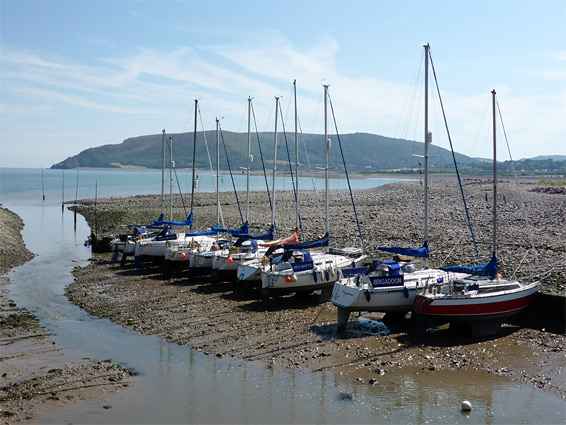
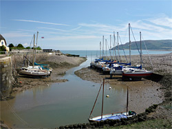
Parking is available at the small, pretty and popular village of Porlock Weir, 2 miles northwest of Porlock, beside a scenic harbour, used by small sailing and fishing boats. The coast path starts along a narrow lane between closely-spaced houses, runs alongside a field then rises steadily through woodland, while shoreline access is via a level track that follows the edge of an estuarine lagoon and another field, before ending at the edge of a broad band of shingle, extending seawards to a the shallow promontory of Gore Point.
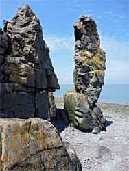
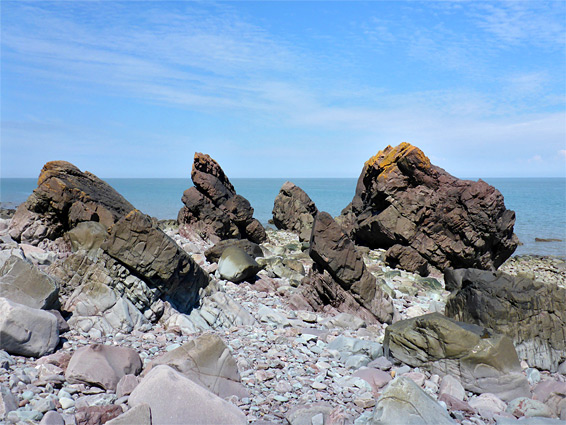
Beyond Gore Point, the intertidal zone narrows, and the pebbles and boulders are soon bordered inland by steep, overgrown and impassable slopes, which continue without significant interruptions for ten miles to Lynmouth, in Devon. The first point of interest is a stone ruin, not marked on maps, followed by a small stream and then the First Rocks, the first place where the bedrock projects seawards, creating a little grassy headland, closely followed by a photogenic collection of pinnacles. Not far beyond are more small sea stacks, the Yellow Rocks. Another stream meets the beach, flowing from Culbone village, then after the jumbled Culbone Rocks is the larger promontory of Ivy Stone, its base uncovered only for a short time around low tide, passable for another couple of hours by wading. Climbing above - ascending around 150 feet to a ridge then scrambling down the far side, might be another option when the tide is high.
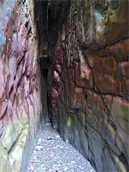
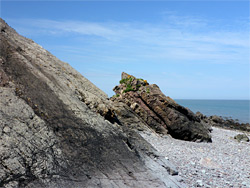
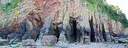
West of Ivy Stone, the pebbly shoreline is straight for over a mile, and little changing in appearance, all along the foot of Culbone Wood. At least two more streams tumble over little cascades at the edge of the beach, from Silcombe Combe and Twitchin Combe. The rather featureless slopes are interrupted by a short cliff-lined section that includes several pinnacles, the tallest named Yellow Stone, presumably on account of its covering of lichen. The land curves outwards not far beyond, while becoming less steep, and the band of pebbles is wider - this is Embelle Wood Beach, reachable from above via two old paths, one emerging from the trees just west of a ruined limekiln at the end of Broomstreet Combe. On the far side of this beach is perhaps the most unusual section of coast hereabouts, where the normally flat strata have been twisted to assorted angles including one section where the layers are vertical, and some of the weaker strata have been eroded backwards by the sea for up to 100 feet to form a series of narrow caves through unusually colourful rocks - green, purple, grey and yellow. These are known collectively, in the matter-of-fact terminology common to this section of the coast, as The Caves. All the rocks in this area are Hangman sandstone, and the land in the vicinity of the caves is protected as Glenthorne Site of Special Scientific Interest.
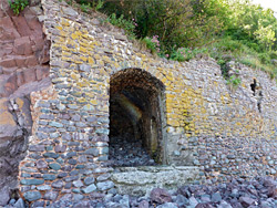
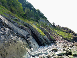
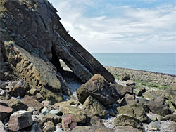
Below the cliffs are a stretch of bigger boulders, requiring more care to traverse, before the loose, rounded pebbles resume, at Glenthorne Beach, which is also reached by a path; the last official route to the coast before Lynmouth, still over five miles away. Beside the end of the path are the ruins of a limekiln and a boat house, above a short embankment, with a line of weathered wooden posts projecting out just below. The splendidly isolated house of Glenthorne can be seen above, on the opposite side of a valley (Yenworthy Combe); the stream from here reaches the beach via a pretty set of cascades, then a short distance beyond is another stream (Coscombe) ending with an eight foot drop into a little pool, a rare example of a coastal waterfall. Nearby are the remains of an old path down from the house, no longer passable. The route back to Porlock Weir starts along the path to Glenthorne Beach but it is worth walking another third of a mile to Giant's Rib, the largest of several ridges of tilted sandstone that protrude from the main line of cliffs, eroded at ground level below the outer strata to form a 40 foot-long cave through yellowish rocks. Beyond, the coastline becomes gradually more rugged, with steeper and rockier slopes, towards the major landmark of Foreland Point.
They path at Glenthorne Beach leads up a slope, past a few junctions then veers southeast, following the small stream in Yenworthy Combe, a shady, wooded glen. The trees are tall and the woods contains much undergrowth, scenery somewhat reminiscent of the great coastal forests of northern California, and indeed the woods do include a few specimens of the coastal redwood, part of the Glenthorne Pinetum, a collection of exotic species planted in the 1850s. A faded map identifies the exact location of some of the most notable trees, though there seem to be no paths through the undergrowth. The trail quite soon intersects the main coast path; turning left, this crosses the stream, cuts back a way then curves east again, levelling out before climbing more, and eventually rising above the trees. A more direct route to Porlock Weir, remaining in the forest, forks left, signed to Culbone Church, and this stays generally level for a long way, through the separate though indistinguishable woods of Yenworthy, Embelle and Culbone, over four significant streams and past occasional open areas that allow views of the sea, up to 500 feet below.
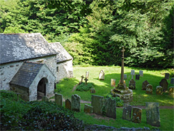
The trail is briefly diverted in a few places to avoid landslips, and this whole section is deemed susceptible to slides, which is one reason why the coast path runs some way above, over less sloping terrain. This path, a vehicle track, eventually rejoins, shortly before the descent to the tiny settlement of Culbone, which consists of two houses and one church, supposedly the smallest in the country, containing 30 seats. The village is only accessible by the track, which is not open to public vehicles. Next to the church, some parts of which are from Saxon times, is a small graveyard, a grassy clearing in the otherwise thickly wooded surroundings.
The Path to Porlock Weir
Porlock Weir is 1.5 miles east of Culbone, reached via at least three paths of similar lengths, through forest that again is fairly level and largely lacking sea views. The trails converge, descending through some sharp bends, and meet a road again at the gatehouse to the Worthy Estate, at the start of an uphill toll section, not open to pedestrians, where vehicles have to pay £2.50 to continue. After this, the coast path soon leaves the road, runs beside a field and arrives back at the village.