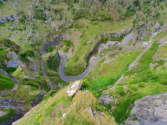
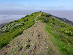
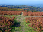
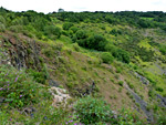
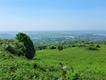
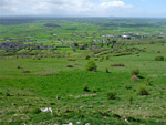
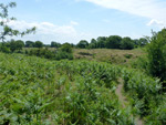
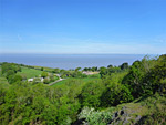
The historical boundaries of Somerset, which today incorporate the unitary authority of North Somerset as well as the traditional county, encompass a good range of landscapes, from the wild uplands of Exmoor National Park to the marshes and fields of the Somerset Levels, and the low coastal plains to the high country of the Quantocks and the Mendips. The levels are generally dead flat but are interrupted by a few small, prominent hills, including Glastonbury Tor and Burrow Mump. Exmoor contains the largest undeveloped areas, though smaller unspoilt regions can be found in the other ranges of hills, the most famous single location being Cheddar Gorge in the Mendips.
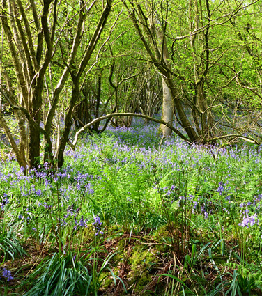
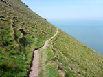
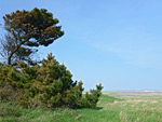
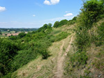
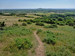
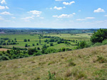
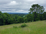
Most of the countryside is agricultural, however; apart from the isolated high ground, the most scenic landscapes are found along the coast, which runs from Portishead in the north, at the mouth of the River Avon, to the tall cliffs west of Porlock, bordering Devon. Somerset contains over 50 nature reserves, concentrated in the hilly areas.
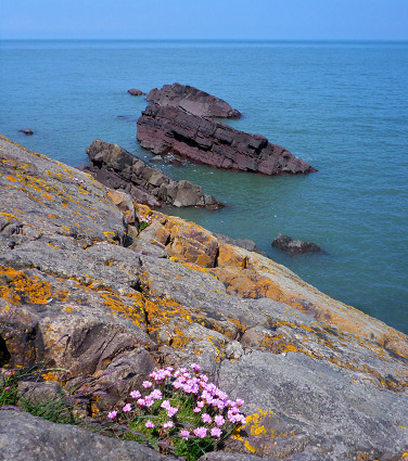
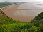
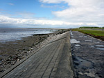
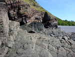
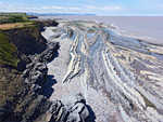
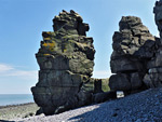
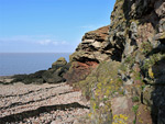
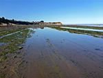
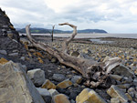
The northern reaches of the coast have some short stretches of rocky formations, southwest of Portishead and around Clevedon, while a little further along are two scenic promontories (Brean Down and Sand Point, both managed by the National Trust), either side of the popular resort town of Weston-super-Mare. South of here, the coast is largely sandy, or muddy, bordered by low, grassy land; past Brean, around the mouth of the River Parrett and west towards Hinkley Point, but further west the shoreline becomes steadily rockier and more scenic, lined now by dark, bluish-grey cliffs formed of inclined strata. Notable areas include the coast near Lilstock, Kilve, Quantoxhead and Watchet, though it is west of Minehead that the scenery becomes most dramatic, as the cliffs here rise very steeply up to 1,000 feet, above long stretches of rarely-visited beaches and eroded formations. Minehead to Hurlstone Point is one such (five mile) section, while the next is west of Porlock, extending into Devon.
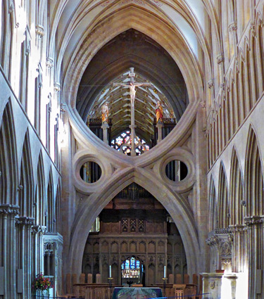
Somerset contains historic sites from various periods including Neolithic, Saxon, Roman, Norman and later, though no category of site is particularly numerous. Of the over 20 castles that were built in the county, only four are complete or substantially intact; the rest have disappeared. The main prehistoric site is the Stanton Drew Stone Circles, the third largest relic of this type in the country, while the best of the early religious buildings are probably Wells Cathedral, Wells Bishop's Palace, Bath Abbey and the ruins of Glastonbury Abbey.
Most of the countryside is agricultural, however; apart from the isolated high ground, the most scenic landscapes are found along the coast, which runs from Portishead in the north, at the mouth of the River Avon, to the tall cliffs west of Porlock, bordering Devon. Somerset contains over 50 nature reserves, concentrated in the hilly areas.
The northern reaches of the coast have some short stretches of rocky formations, southwest of Portishead and around Clevedon, while a little further along are two scenic promontories (Brean Down and Sand Point, both managed by the National Trust), either side of the popular resort town of Weston-super-Mare. South of here, the coast is largely sandy, or muddy, bordered by low, grassy land; past Brean, around the mouth of the River Parrett and west towards Hinkley Point, but further west the shoreline becomes steadily rockier and more scenic, lined now by dark, bluish-grey cliffs formed of inclined strata. Notable areas include the coast near Lilstock, Kilve, Quantoxhead and Watchet, though it is west of Minehead that the scenery becomes most dramatic, as the cliffs here rise very steeply up to 1,000 feet, above long stretches of rarely-visited beaches and eroded formations. Minehead to Hurlstone Point is one such (five mile) section, while the next is west of Porlock, extending into Devon.
Somerset contains historic sites from various periods including Neolithic, Saxon, Roman, Norman and later, though no category of site is particularly numerous. Of the over 20 castles that were built in the county, only four are complete or substantially intact; the rest have disappeared. The main prehistoric site is the Stanton Drew Stone Circles, the third largest relic of this type in the country, while the best of the early religious buildings are probably Wells Cathedral, Wells Bishop's Palace, Bath Abbey and the ruins of Glastonbury Abbey.
Ancient Sites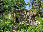 Fragmentary remains of a tiny medieval chapel, in the coastal woodland west of Minehead Rating: ★★★★★ |
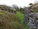
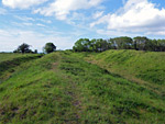 Ditches and embankments from a large Iron Age hillfort, on high ground overlooking the Severn Estuary Rating: ★★★★★ |
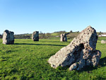 Three prehistoric stone circles, the largest 370 feet in diameter, and a separate group of three stones known as the Cove Rating: ★★★★★ |
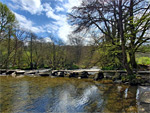 Ancient stone footbridge across the River Barle, part of a woodland nature reserve Rating: ★★★★★ |
Castles and MansionsDunster Castle - medieval castle, later converted to a country house, retaining only a small number of original features. Surrounded by extensive gardens, and managed by the National Trust |
 Ruins of a quadrangular castle with outer court, plus a chapel containing tombs and wall paintings, and a crypt holding eight lead coffins Rating: ★★★★★ |
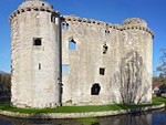 Small but well-built and picturesque 14th century castle, surrounded by a moat and overlooking a stream, in the centre of a quiet country village Rating: ★★★★★ |
Taunton Castle - 12th century fortification on the banks of the River Tone, reconstructed on several occasions but retaining some original features; home to the Museum of Somerset |
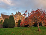 19th century gothic revival mansion with chapel and formal gardens, surrounded by extensive grounds Rating: ★★★★★ |
Cathedrals, and other major churches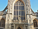 Fine parish church renowned for its perpendicular Gothic architecture, on the site of an ancient monastery; the oldest sections are from the 12th century Rating: ★★★★★ |
 Small parish church in a rural setting, some parts dating from the 13th century Rating: ★★★★★ |
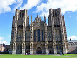 One of England's most beautiful cathedrals; built in a Gothic style, mostly during the 13th century Rating: ★★★★★ |
Coastline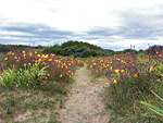 Grassy and sandy dunes stretching over 2 miles along the west Somerset coast, partly occupied by a golf course and partly by a local nature reserve Rating: ★★★★★ |
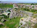
 High, narrow limestone peninsula along the north Somerset coast, lined by cliffs; site of a 19th century fort and several more ancient relics Rating: ★★★★★ |
 Four mile stretch of the coast; limestone cliffs and some pebble beaches, but mostly saltmarsh and grassy fieldss Rating: ★★★★★ |
 Saltmarsh, fields, ruins and a long pebble beach, between two sandstone headlands Rating: ★★★★★ |
 Four mile stretch of the coast, including Kilve Pill and Quantock's Head, with layered, blue lias cliffs above extensive, wave-cut terraces Rating: ★★★★★ |
 Cliffs and pebble beaches along a spectacular, little-visited, five mile section of the north Somerset coast Rating: ★★★★★ |
 Five miles of the Somerset coast; rarely-seen beaches and eroded sandstone formations below steep cliffs and extensive ancient woodland Rating: ★★★★★ |
 Low cliffs, eroded rocks, pebble beaches and a lighthouse, along the Bristol Channel coastline south of Portishead Rating: ★★★★★ |
 Narrow promontory and elevated headland overlooking the Bristol Channel, lined by stony beaches and eroded rock formations Rating: ★★★★★ |
 Peninsula between Bridgewater Bay and the River Parrett; sand and shingle beaches, mudflats and saltmarsh Rating: ★★★★★ |
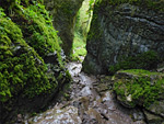
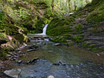
 Three mile stretch of the coast, with layered cliffs, pebble banks, wave-cut terraces, sand/mud beaches and a moss-lined waterfall Rating: ★★★★★ |
 6.5 miles of coastline; complex cliffs and rock formations, giving way to grassland and sand/pebble beaches Rating: ★★★★★ |
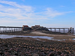 Rocky, cliff-lined beach of pebbles, sand and mud, and a tidal island linked by a derelict pier, on the north side of Weston-super-Mare Rating: ★★★★★ |
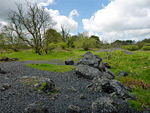
Landscapes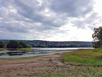 440 acre reservoir at the foot of the Mendip Hills, formed by a dam across the River Yeo Rating: ★★★★★ |
 The highest summit of the Mendip Hills, at the centre of a sizable area of moorland, and a narrow, winding, cliff-lined valley concealing several caves Rating: ★★★★★ |
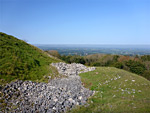
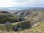 Famous limestone ravine at the south edge of the Mendip Hills, containing several caves, and viewable via a 3 mile loop path Rating: ★★★★★ |
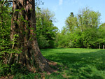
 Shady, moist valley at the west edge of the Ashton Court Estate south of Bristol, filled with ancient oak and beech trees Rating: ★★★★★ |
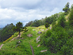
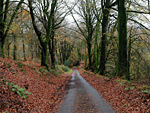
 Wooded valleys in the Quantock Hills, and a section of the ancient ridgeline path Rating: ★★★★★ |
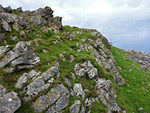 Rocky summit with excellent views; the most distinctive peak in the Mendip Hills Rating: ★★★★★ |
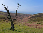
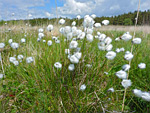
The highest point on Exmoor, surrounded by gentle slopes covered with heather and gorse, overlooking Porlock Bay and the Bristol Channel Rating: ★★★★★ |
 Narrow, densely wooded limestone ravine near Wookey Hole along the south edge of the Mendip Hills Rating: ★★★★★ |
 Wooded valley and a 1,018 foot summit overlooking the Bristol Channel; in the northern half of the Quantock Hills Rating: ★★★★★ |
Nature Reserves, and similar places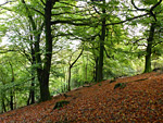 Broad-leaved woodland across a north-facing slope at the end of a ridge on the east side of the Quantock Hills, bordered by a stream Rating: ★★★★★ |
 Coppiced ancient woodland extending 2 miles along a steep, west-facing slope, overlooking the Somerset Levels Rating: ★★★★★ |
 Badgers Wood and Jubilee Stone Wood; mixed broad-leaved woodland on the opposite slopes of a dry valley, plus calcareous grassland Rating: ★★★★★ |
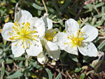
 Varied habitats including limestone heath, open water and lead mine workings, supporting several rare plant species Rating: ★★★★★ |
 Two tree-lined fields containing a spring-line mire, the waters from which flow into the River Culm Rating: ★★★★★ |
 Ancient ash woodland on steeply sloping ground above the River Avon, plus several old quarries, now colonised by calcareous grassland Rating: ★★★★★ |
 Small nature reserve on the southern slopes of the Mendip Hills; mostly grassland, with some trees, bracken and limestone exposures Rating: ★★★★★ |
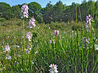
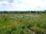
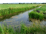 Wet pasture on the Somerset Levels, lined by ditches and rhynes; good for riparian plants and wading birds Rating: ★★★★★ |
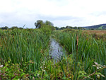
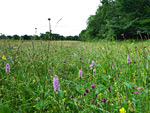
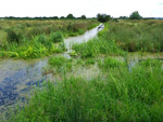
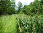 Wet habitats on the Somerset Levels; woodland, marsh, fen, rhynes, reedbeds and hay meadows Rating: ★★★★★ |
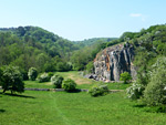 Three adjacent, contrasting nature reserves across the upper reaches of Cheddar Gorge; Black Rock, Long Wood and Velvet Bottom Rating: ★★★★★ |
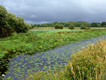
 Wet meadows on low-lying ground in the Gordano Valley, lined by ditches and rhynes containing a wide variety of plant species Rating: ★★★★★ |
 Varied plant habitals on a northern outlier of the Mendip Hills, including extensive calcareous grassland, plus an ancient hillfort Rating: ★★★★★ |
 Mature oak/beech woodland on steeply-sloping ground at the east edge of the Blackdown Hills Rating: ★★★★★ |
 Nature reserve at the southern edge of the Mendip Hills; good views and over 150 wildflower species Rating: ★★★★★ |
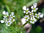 Cultivated fields on calcium-rich soils, supporting an usually wide range of plant species, many nationally rare Rating: ★★★★★ |
 Field of wet, neutral grassland to the north, and drier acidic grassland on calcareous soils to the south Rating: ★★★★★ |
 Shady, thickly wooded valley below patches of calcareous grassland; the lower end is a nature reserve Rating: ★★★★★ |
 Mixed woodland on flat, elevated ground towards the east end of the Polden Hills, crossed by paths and tracks Rating: ★★★★★ |
 Limestone downland across a south-facing slope above the valley of the River Cary; home to the large blue butterfly Rating: ★★★★★ |
 Calcareous grassland nature reserve on a western outlier of the Mendip Hills; varied wildflowers and long distance views Rating: ★★★★★ |
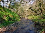 Streamside vegetation and ancient deciduous woodland on the east side of the Quantock Hills Rating: ★★★★★ |
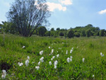
 Remote nature reserve comprising a wood, a section of stream and two fields of neutral grassland, with many wildflowers Rating: ★★★★★ |
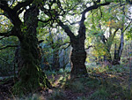
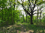
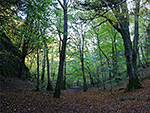
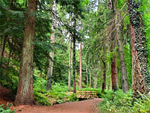
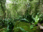
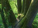
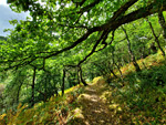 The largest area of ancient oak woodland in Britain, spread across the steep-sided valleys of Horner Water and its tributaries Rating: ★★★★★ |
 Extensive woodland on the west side of the Avon Gorge, crossed by many paths, and home to rare plant species; a national nature reserve Rating: ★★★★★ |
 Pasture, hay meadows and boggy heath, on high ground in the middle of the Mendips Rating: ★★★★★ |
 Ancient woodland on steeply-sloping ground on the south side of the Mendip Hills Rating: ★★★★★ |
 Moist, shady valley planted with conifers, one of which is now the tallest tree in England Rating: ★★★★★ |
 Varied habitats across a lead-mining site on the Mendip Hills: calcareous grassland, heath, valley mire, fen and open water Rating: ★★★★★ |
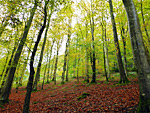
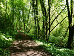
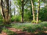
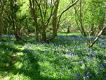
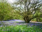 Ancient woodland across the slopes of a limestone ridge, with seasonal streams lower down; especially good for bluebells in the spring Rating: ★★★★★ |
 Three fields on steeply-sloping, calcareous ground, with several rare plant species, and good views over the Somerset Levels Rating: ★★★★★ |
 Nature reserve on a western outlier of the Mendip Hills, with good views south and towards the coast; home to many plant species, three particularly rare Rating: ★★★★★ |
 Part of the Avon Levels; around 70 fields of damp pasture lined by water-filled rhynes containing many species of aquatic plants Rating: ★★★★★ |
 Deciduous woodland, mainly ash and lime, and calcareous grassland, along steep, south-facing slopes at the edge of the Mendip Hills Rating: ★★★★★ |
 Great variety of wetland habitats on the Somerset Levels, covering a large area, 2.5 miles across Rating: ★★★★★ |
 Secluded nature reserve centred on a stream and waterfall, enclosed by wooded slopes; good for wildflowers in the spring Rating: ★★★★★ |
 Small, little-visited nature reserve of sloping grassland and a few trees, in the Mendip Hills Rating: ★★★★★ |
 Small nature reserve within the Mendip Hills, containing overgrown lead mine workings, now home to a variety of wildlife Rating: ★★★★★ |
 Adjacent nature reserves beside the west Somerset coast: coastal meadows and marshes, and a wildflower-covered peak Rating: ★★★★★ |
 Secluded nature reserve on a partly wooded ridge, overlooking Gordano Valley and the Bristol Channel Rating: ★★★★★ |
 Ancient woodland on a ridge between Gordano Valley and the Bristol Channel; many bluebells in spring, and several rare plant species Rating: ★★★★★ |
 Two streams flowing through narrow, wooded, steep-sided gorges, plus a pair of wildflower-rich meadows Rating: ★★★★★ |
 Minor nature reserve on the Somerset Levels; two gently sloping fields of rough grassland, where a variety of plants and animals may be seen Rating: ★★★★★ |
 Rough, wet grassland near the source of the River Yarty in the Blackdown Hills, with many unusual plant species Rating: ★★★★★ |
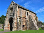
Ruined Abbeys, and other old religious buildings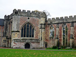 Extensive, moated, castle-like residence of the bishops of Bath and Wells, begun in the 13th century; one ruined section, the great hall, but otherwise intact Rating: ★★★★★ |
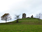 Isolated, conical hill rising 70 feet above the flat, marshy farmland of the Somerset Levels, topped by a ruined, 18th century church Rating: ★★★★★ |
 Cistercian monastery in a quiet, rural setting with many original, well preserved buildings, mostly from the 13th century, plus the foundations of the abbey church Rating: ★★★★★ |
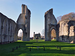 Imposing and evocative ruins of a famous and wealthy monastery, established in the 7th century Rating: ★★★★★ |
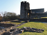
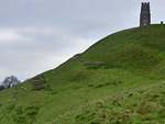 Famous limestone hill topped by the ruined tower of the 14th century St Michael's Church Rating: ★★★★★ |
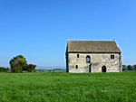 Two floor building on the Somerset Levels, constructed in the 1330s by the monks of Glastonbury Abbey Rating: ★★★★★ |
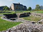 Relics from an ancient Benedictine monastery; abbot's house, reredorter and part of the cloisters, together with extensive wall foundations Rating: ★★★★★ |