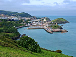
Apart from two small areas at Westwood Ho! and Ilfracombe, all of the coast of north Devon is nationally protected, part of Exmoor National Park for the eastern 15 miles (to Combe Martin), continuing into Somerset, and as the North Devon Coast Area of Outstanding Natural Beauty for the remainder, adjoining the Hartland section of the Cornwall AONB. The Devon preserve varies in width from over four miles to less than one, and beside the actual coastline, a mix of cliffs, rocky coves, pebble banks, sandy beaches and dunes, it contains varied inland scenery of wooded combes, broad valleys, rolling farmland, coastal moorland and estuarine rivers, principally the Torridge and the Taw. The boundaries of the AONB are generally defined to include the catchment area of all the small streams that drain the coastal strip.
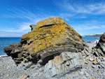
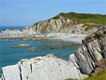
Rocks in the southern half of the AONB, south of the Taw, are nearly homogenous, thin-layered sandstones and mudstones from the Holsworthy Group, while to the north the strata are more varied, both in colour and form, but nearly all of coast is predominantly rocky, the main exceptions being the three broad beaches of Woolacombe Sands, Braunton Burrows (Saunton Sands) and Northam Burrows.
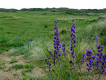
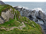
Unlike the sea cliffs further east, beyond Combe Martin, the land does not rise especially high, and the cliffs are less continuous, so although the coast path is mostly some distance above the water there are many places where it is possible to walk down to beach level. For wildflowers the single best location is Braunton Burrows, a UNESCO World Biosphere Reserve and one the largest dune fields in the country; over 400 vascular plant species are found here.
Rocks in the southern half of the AONB, south of the Taw, are nearly homogenous, thin-layered sandstones and mudstones from the Holsworthy Group, while to the north the strata are more varied, both in colour and form, but nearly all of coast is predominantly rocky, the main exceptions being the three broad beaches of Woolacombe Sands, Braunton Burrows (Saunton Sands) and Northam Burrows.
Unlike the sea cliffs further east, beyond Combe Martin, the land does not rise especially high, and the cliffs are less continuous, so although the coast path is mostly some distance above the water there are many places where it is possible to walk down to beach level. For wildflowers the single best location is Braunton Burrows, a UNESCO World Biosphere Reserve and one the largest dune fields in the country; over 400 vascular plant species are found here.
Landscapes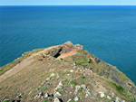 Cliff-lined headland with some rocky terraces; interesting geology and varied wildflowers Rating: ★★★★★ |
 The second largest dune system in the UK; numerous plant and animal species Rating: ★★★★★ |
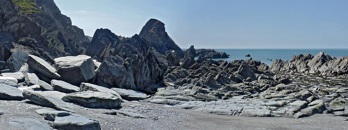
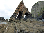 Tall cliffs, a famous village, and a wooded valley leading to Mouthmill Beach, site of Blackchurch Rock, a double arch Rating: ★★★★★ |
 Pebble beaches, cliffs, rock formations and two small waterfalls, below ancient woodland Rating: ★★★★★ |
 Spectacular, five mile section of the Hartland Peninsula; cliffs and steep slopes above rock, pebble and sand beaches Rating: ★★★★★ |
 Coastal walk mostly high above the sea, along the top of big cliffs, but with various sea level access points Rating: ★★★★★ |
 Slate cliffs, eroded formations and secluded beaches along the northwestern part of the coast Rating: ★★★★★ |