The Mendip Hills of north Somerset are the southernmost range of limestone uplands in the UK, extending west-east for nearly 30 miles between Weston-super-Mare and Frome. The western edge narrows to a prominent ridge (Bleadon Hill) while to the east the hills widen, with north and south edges up to five miles apart, to the vicinity of Wells and Chewton Mendip, beyond which the land is generally lower, and the edge of the hills less well-defined. The more spectacular western section is contained within the 77 square mile Mendip Hills Area of Outstanding National Beauty, the boundaries of which generally coincide with the lower edge of the hills, but extend northwards a little to include two reservoirs, Blagdon Lake and Chew Valley Lake.
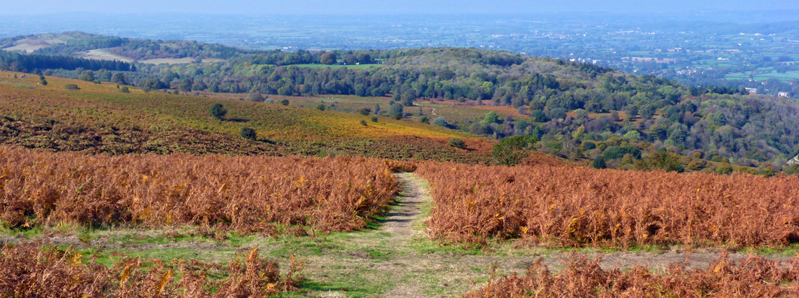
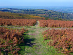
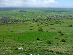
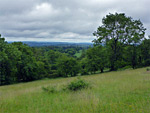
Within the AONB the south edge of the Mendips is most prominent - a nearly straight escarpment up to 600 feet in elevation, overlooking the Somerset Levels, while the northern edge is more undulating, split by valleys, but is similarly bordered by flat, low-lying land, from Puxton Moor and Congresbury Moor, across to the Chew Valley. The highest point of the hills is Black Down, 1,066 feet, and this is surrounded by a sizeable patch of open moorland, one of only two such regions, the other being around Cook Peak in the west. Instead, the majority of the hills is walled farmland, used for livestock grazing and growing crops, though there are many smaller areas in a natural state, including over a dozen nature reserves, the best of which are Cheddar Complex, Dolebury Warren, Draycott Sleights and Ubley Warren.
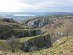
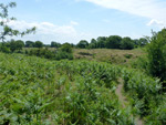
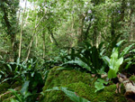
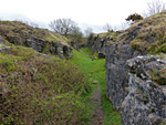
Calcareous grassland is the main plant habitat in the Mendips, along with ancient broad-leaved woodland (ash and maple), which covers much of the north and south slopes. The hills are cut by ravines and combes, of which Cheddar Gorge and Ebbor Gorge are the most famous, and the carboniferous limestone bedrock contains innumerable caves, one of which (Wookey Hole) is a developed tourist attraction. Across the plateau are dozens of ancient monuments, including ditches, burial mounds and standing stones. The hills are crossed by many roads, tracks and paths, including two long-distance trails, the West Mendip Way from Uphill to Wells, and the East Mendip Way from Wells to Frome, outside the AONB.
Within the AONB the south edge of the Mendips is most prominent - a nearly straight escarpment up to 600 feet in elevation, overlooking the Somerset Levels, while the northern edge is more undulating, split by valleys, but is similarly bordered by flat, low-lying land, from Puxton Moor and Congresbury Moor, across to the Chew Valley. The highest point of the hills is Black Down, 1,066 feet, and this is surrounded by a sizeable patch of open moorland, one of only two such regions, the other being around Cook Peak in the west. Instead, the majority of the hills is walled farmland, used for livestock grazing and growing crops, though there are many smaller areas in a natural state, including over a dozen nature reserves, the best of which are Cheddar Complex, Dolebury Warren, Draycott Sleights and Ubley Warren.
Calcareous grassland is the main plant habitat in the Mendips, along with ancient broad-leaved woodland (ash and maple), which covers much of the north and south slopes. The hills are cut by ravines and combes, of which Cheddar Gorge and Ebbor Gorge are the most famous, and the carboniferous limestone bedrock contains innumerable caves, one of which (Wookey Hole) is a developed tourist attraction. Across the plateau are dozens of ancient monuments, including ditches, burial mounds and standing stones. The hills are crossed by many roads, tracks and paths, including two long-distance trails, the West Mendip Way from Uphill to Wells, and the East Mendip Way from Wells to Frome, outside the AONB.
Landscapes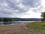 440 acre reservoir at the foot of the Mendip Hills, formed by a dam across the River Yeo Rating: ★★★★★ |
 The highest summit of the Mendip Hills, at the centre of a sizable area of moorland, and a narrow, winding, cliff-lined valley concealing several caves Rating: ★★★★★ |
 Famous limestone ravine at the south edge of the Mendip Hills, containing several caves, and viewable via a 3 mile loop path Rating: ★★★★★ |
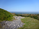
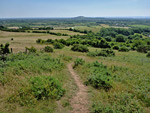
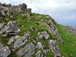 Rocky summit with excellent views; the most distinctive peak in the Mendip Hills Rating: ★★★★★ |
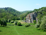
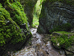 Narrow, densely wooded limestone ravine near Wookey Hole along the south edge of the Mendip Hills Rating: ★★★★★ |
Nature Reserves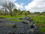 Varied habitats including limestone heath, open water and lead mine workings, supporting several rare plant species Rating: ★★★★★ |
 Small nature reserve on the southern slopes of the Mendip Hills; mostly grassland, with some trees, bracken and limestone exposures Rating: ★★★★★ |
 Three adjacent, contrasting nature reserves across the upper reaches of Cheddar Gorge; Black Rock, Long Wood and Velvet Bottom Rating: ★★★★★ |
 Varied plant habitals on a northern outlier of the Mendip Hills, including extensive calcareous grassland, plus an ancient hillfort Rating: ★★★★★ |
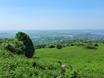
 Nature reserve at the southern edge of the Mendip Hills; good views and over 150 wildflower species Rating: ★★★★★ |
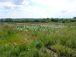
 Field of wet, neutral grassland to the north, and drier acidic grassland on calcareous soils to the south Rating: ★★★★★ |
 Calcareous grassland nature reserve on a western outlier of the Mendip Hills; varied wildflowers and long distance views Rating: ★★★★★ |
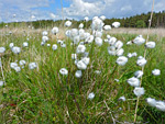
 Pasture, hay meadows and boggy heath, on high ground in the middle of the Mendips Rating: ★★★★★ |
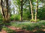 Ancient woodland on steeply-sloping ground on the south side of the Mendip Hills Rating: ★★★★★ |
 Varied habitats across a former lead-mining site: calcareous grassland, heath, valley mire, fen and open water Rating: ★★★★★ |
 Deciduous woodland, mainly ash and lime, and calcareous grassland, along steep, south-facing slopes at the edge of the Mendip Hills Rating: ★★★★★ |
 Small, little-visited nature reserve of sloping grassland and a few trees, in the Mendip Hills Rating: ★★★★★ |
 Small nature reserve within the Mendip Hills, containing overgrown lead mine workings, now home to a variety of wildlife Rating: ★★★★★ |