Southwest UK is justifiably famous for its spectacular coastline, some parts of which are easy to reach though others are rarely visited; even the coast path has to run quite far inland in places, up to half a mile, owing to steep slopes below, in particular the western part of Somerset, and some sections of north and south Devon. The majority of the coast is lined by cliffs, terraces and eroded rock formations, with sand or pebble beaches at intervals; only along on the upper reaches of the Severn Estuary is the scenery less interesting, since here the sea is mostly bordered by mudbanks and flat grassland.
The coast in this part of the UK can be divided into three sections - south Wales, Somerset/north Devon, and Dorset/south Devon.
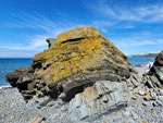
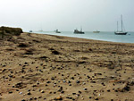
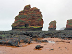
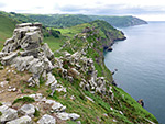
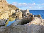
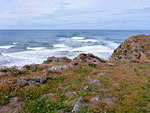
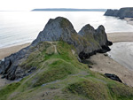
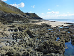
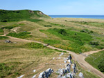
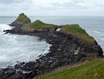
Starting in the east, the south Wales coast becomes scenic just beyond Cardiff (at Lavernock Point), as here the muddy flats are replaced by extensive outcrops of thin-layered limestone, which extend all along the edge of Vale of Glamorgan to Ogmore-by-Sea, a 14 mile section known as the Glamorgan Heritage Coast. Other notable areas include Aberthaw to Stout Bay, Stout Bay to Nash Point and Temple Bay to Dunraven Bay. From Ogmore to Swansea the coast was once covered by a huge dune system stretching up to 2 miles inland, and this survives in two main locations (Merthyr Mawr and Kenfig, both national nature reserves), the remainder long since replaced by the suburbs of Port Talbot and the adjacent steelworks. Rocks return west of Swansea, mostly carboniferous limestone, and also heavily eroded, lining the south and west sides of the Gower Peninsula, below which are a number of popular, sandy beaches, principally Langland, Caswell, Three Cliffs Bay, Oxwich, Port Eynon, Mewslade and Rhossilli. Two other notable locations are the dramatic promontory of Worm's Head at the southwestern tip of the peninsula, and the remote dunes of Whiteford National Nature Reserve in the northwest. Further west are the broad inlets of the Loughor and Towy rivers, before the even more extensive cliffs and beaches of Pembrokeshire.
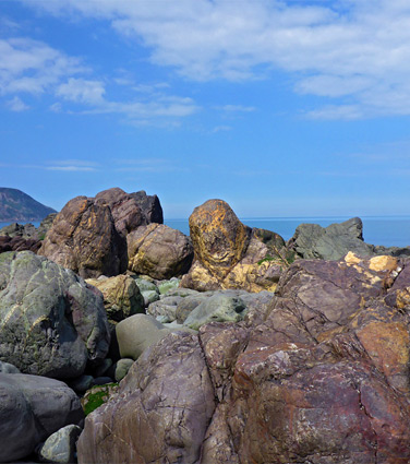
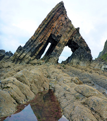
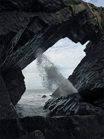
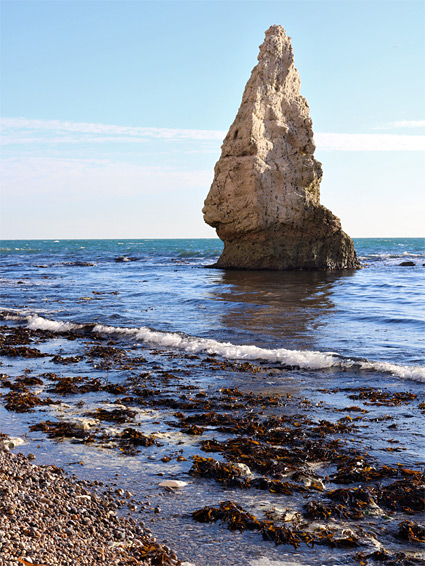
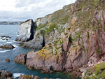
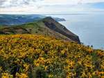
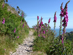
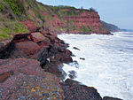
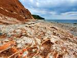
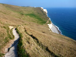
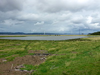
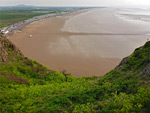
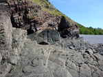
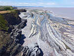
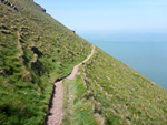
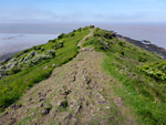
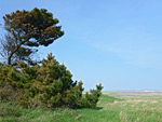
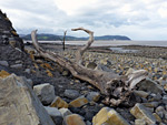
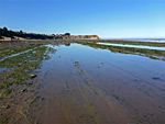
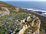
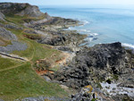
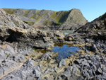
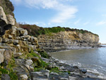
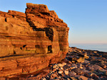
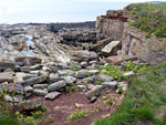
The predominantly low, mud-lined coast along the south side of the Bristol Channel is interrupted by few rocky outcrops, at Aust (in Gloucestershire) and from Portishead to Clevedon, then at Sand Point, Worlebury Hill and Brean Down, all in Somerset, but there is not much else of photographic interest on this stretch, southwards to the mouth of the River Parrett. West of the river are several miles of dunes and broad, pebble beaches including Fennig Island National Nature Reserve, until beyond the Hinkley Point power station, where low cliffs appear, formed of the same grey/blue lias that is exposed on the opposite side of the Bristol Channel, in Glamorgan. These rocks stretch for 12 miles, to Blue Anchor Bay near Minehead, with perhaps the most scenic stretch being the 4 miles between Lilstock and St Audrie's Bay. Further west in Somerset, continuing into north Devon, the land rises steeply by up to 1,000 feet, along the edge of Exmoor, forming spectacular cliffs cloaked by dense coastal forests, explorable from above via the coast path, and below by careful walking at sea level, at low tide. Sections include Minehead to Hurlstone Point, Porlock Weir to Glenthorne Beach, Glenthorne Beach to Foreland Point and Valley of Rocks to Woody Bay. This region includes the highest sea cliffs in England, and some of its most isolated, inaccessible terrain.
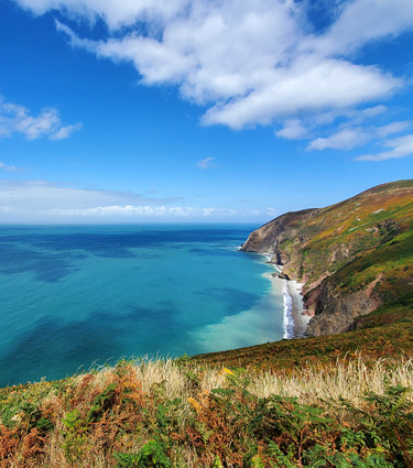
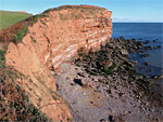
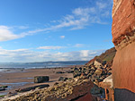
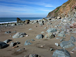
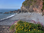
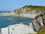
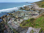
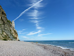
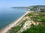
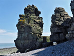
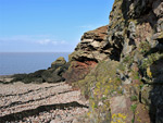
The most famous section of the south Devon and south Dorset shoreline is the Jurassic Coast, a World Heritage site, covering the 95 miles between Orcombe Point, near Exmouth in Devon, and Old Harry Rocks, south of Bournemouth in Dorset - all is lined with sand/pebble beaches below fossiliferous rocks, varying greatly in colour, orientation, form and hardness. As with north Devon, most is usually explored from above, along the coast path, though nearly all is also accessible at sea level, at least around low tide. Notable sections, from west to east, include Exmouth to Budleigh Salterton, Budleigh Salterton to Ladram Bay, Ladram Bay to Sidmouth, Branscombe to Beer, Axmouth to Lyme Regis, Lyme Regis to Seatown and Durdle Door to Lulworth Cove. Further south, the Devon coast stays mostly cliff-bound but becomes more rugged and irregular, with smaller beaches, and is generally less accessible.
The coast in this part of the UK can be divided into three sections - south Wales, Somerset/north Devon, and Dorset/south Devon.
South Wales
Starting in the east, the south Wales coast becomes scenic just beyond Cardiff (at Lavernock Point), as here the muddy flats are replaced by extensive outcrops of thin-layered limestone, which extend all along the edge of Vale of Glamorgan to Ogmore-by-Sea, a 14 mile section known as the Glamorgan Heritage Coast. Other notable areas include Aberthaw to Stout Bay, Stout Bay to Nash Point and Temple Bay to Dunraven Bay. From Ogmore to Swansea the coast was once covered by a huge dune system stretching up to 2 miles inland, and this survives in two main locations (Merthyr Mawr and Kenfig, both national nature reserves), the remainder long since replaced by the suburbs of Port Talbot and the adjacent steelworks. Rocks return west of Swansea, mostly carboniferous limestone, and also heavily eroded, lining the south and west sides of the Gower Peninsula, below which are a number of popular, sandy beaches, principally Langland, Caswell, Three Cliffs Bay, Oxwich, Port Eynon, Mewslade and Rhossilli. Two other notable locations are the dramatic promontory of Worm's Head at the southwestern tip of the peninsula, and the remote dunes of Whiteford National Nature Reserve in the northwest. Further west are the broad inlets of the Loughor and Towy rivers, before the even more extensive cliffs and beaches of Pembrokeshire.
Somerset and North Devon
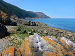
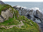
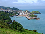
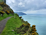
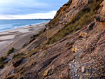
The predominantly low, mud-lined coast along the south side of the Bristol Channel is interrupted by few rocky outcrops, at Aust (in Gloucestershire) and from Portishead to Clevedon, then at Sand Point, Worlebury Hill and Brean Down, all in Somerset, but there is not much else of photographic interest on this stretch, southwards to the mouth of the River Parrett. West of the river are several miles of dunes and broad, pebble beaches including Fennig Island National Nature Reserve, until beyond the Hinkley Point power station, where low cliffs appear, formed of the same grey/blue lias that is exposed on the opposite side of the Bristol Channel, in Glamorgan. These rocks stretch for 12 miles, to Blue Anchor Bay near Minehead, with perhaps the most scenic stretch being the 4 miles between Lilstock and St Audrie's Bay. Further west in Somerset, continuing into north Devon, the land rises steeply by up to 1,000 feet, along the edge of Exmoor, forming spectacular cliffs cloaked by dense coastal forests, explorable from above via the coast path, and below by careful walking at sea level, at low tide. Sections include Minehead to Hurlstone Point, Porlock Weir to Glenthorne Beach, Glenthorne Beach to Foreland Point and Valley of Rocks to Woody Bay. This region includes the highest sea cliffs in England, and some of its most isolated, inaccessible terrain.
Dorset and South Devon
The most famous section of the south Devon and south Dorset shoreline is the Jurassic Coast, a World Heritage site, covering the 95 miles between Orcombe Point, near Exmouth in Devon, and Old Harry Rocks, south of Bournemouth in Dorset - all is lined with sand/pebble beaches below fossiliferous rocks, varying greatly in colour, orientation, form and hardness. As with north Devon, most is usually explored from above, along the coast path, though nearly all is also accessible at sea level, at least around low tide. Notable sections, from west to east, include Exmouth to Budleigh Salterton, Budleigh Salterton to Ladram Bay, Ladram Bay to Sidmouth, Branscombe to Beer, Axmouth to Lyme Regis, Lyme Regis to Seatown and Durdle Door to Lulworth Cove. Further south, the Devon coast stays mostly cliff-bound but becomes more rugged and irregular, with smaller beaches, and is generally less accessible.
England
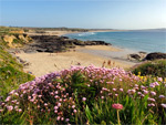
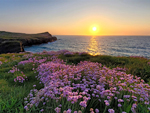
Cornwall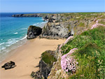 Sea stacks and a wide sandy beach, at the foot of steep, wildflower-covered cliffs Rating: ★★★★★ |
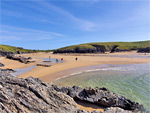
 Broad sandy beach bordered by terraces and cliffs of dark-coloured slate, beneath sandy bluffs bearing varied wildflowers Rating: ★★★★★ |
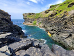
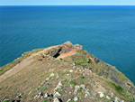
 Dramatic rocky headland, lined by small coves and sheer cliffs, toured by a 2.6 mile loop path Rating: ★★★★★ |
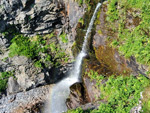 Hundred foot coastal waterfall, above an inaccessible pebble beach and cliff-lined bay frequented by seals Rating: ★★★★★ |
 Secluded, cliff-lined sandy beach, with rock pools at low tide and a stream flowing through Rating: ★★★★★ |
 Short wooded ravine giving way to a dramatic cliff-lined gorge that meets the sea Rating: ★★★★★ |
 Cliff-lined promontory and island just north of Newquay, with sandy beaches at either side Rating: ★★★★★ |
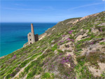 One of the most spectacular old tin mines in Cornwall, a photogenic group of ruined buldings right by the coast Rating: ★★★★★ |
Devon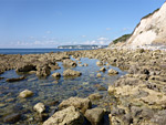 Cliffs, beaches and landslips along a remote, 7 mile section of the Jurassic Coast; includes Haven Cliffs, Goat Island, Charton Bay and Pinhay Bay Rating: ★★★★★ |
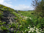
 Cliff-lined headland with some rocky terraces; interesting geology and varied wildflowers Rating: ★★★★★ |
 The second largest dune system in the UK; numerous plant and animal species Rating: ★★★★★ |
 Tall cliffs, a famous village, and a wooded valley leading to Mouthmill Beach, site of Blackchurch Rock, a double arch Rating: ★★★★★ |
 Pebble beaches, cliffs, rock formations and two small waterfalls, below ancient woodland Rating: ★★★★★ |
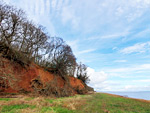
 Red-rock coastline east of the River Otter; sheer cliffs above narrow, inaccessible beaches and marine terraces Rating: ★★★★★ |
 Cliff-lined island opposite the popular sandy beach at Bigbury-on-Sea Rating: ★★★★★ |
 The coast east of Combe Martin, rising to the highest seacliff in England, 1,043 foot Great Hangman Rating: ★★★★★ |
 Sandy promontory at the mouth of the River Exe containing varied habitats, home to many plant species Rating: ★★★★★ |
 The westernmost four miles of the Jurassic Coast; richly-coloured red cliffs and sand/pebble beaches Rating: ★★★★★ |
 2.5 miles of north Devon coastline, from a high headland to the mouth of the River Lyn Rating: ★★★★★ |
 Spectacular, three mile section of the north coast, with dense woodland sloping steeply down to remote beaches and eroded rock formations Rating: ★★★★★ |
 Spectacular, five mile section of the Hartland Peninsula; cliffs and steep slopes above rock, pebble and sand beaches Rating: ★★★★★ |
 Cliff-lined pebble and sand beach at the lower end of the River Heddon, reached by an easy walk along a deep, secluded, wooded valley Rating: ★★★★★ |
 Four mile section of the north Devon coast, between two deep valleys, inaccessible at sea level but followed by the coast path up to 900 feet above Rating: ★★★★★ |
 Coastal walk mostly high above the sea, along the top of big cliffs, but with various sea level access points Rating: ★★★★★ |
 Path from Lynmouth, climbing through woodland then traversing precipitous slopes to a rocky valley, with optional descent to the isolated Wringcliff Beach Rating: ★★★★★ |
 Slate cliffs, eroded formations and secluded beaches along the northwestern part of the Devon coast Rating: ★★★★★ |
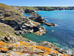
 Narrow inlets, tiny beaches and grassy promontories, and much colourful, jagged, eroded rock Rating: ★★★★★ |
 Six miles of the south Devon coast; pebble and sand beaches, and rock formations, below crumbling red mudstone cliffs Rating: ★★★★★ |
 Three mile stretch of the east Devon coastline near Teignmouth, lined by high cliffs of red breccia, Rating: ★★★★★ |
 Sheer cliffs, sea caves and scenic beaches either side of Beer, along the Jurassic Coast. Also many summer wildflowers Rating: ★★★★★ |
 Red sandstone cliffs, isolated beaches and large sea stacks; part of the Jurassic Coast Rating: ★★★★★ |
 Rock formations, isolated beaches, steep cliffs and coastal woodland, west of Lynton. Includes Wringcliff Bay and Lee Bay Rating: ★★★★★ |
 Rugged section of the coastline, from the River Erme, eastwards, also including Fernycombe Point and Westcombe Beach Rating: ★★★★★ |
Two miles of coastline, including the rocky headland of Highveer Point and the valley of Hollow Brook, which forms a tall waterfall Rating: ★★★★★ |
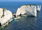
Dorset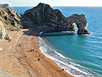 Sea arch and a circular cove, part of a varied section of the coast that also has headlands, sandy beaches, chalk cliffs and other eroded formations Rating: ★★★★★ |
 Cliff-bound section of the Jurassic Coast on the Studland Peninsula, including Anvil Point, Dancing Ledge and Headbury Quarry Rating: ★★★★★ |
 Headland centred on a hill of colourful sedimentary rock; also has wetlands, dunes, heath, sandy beaches and saltmarsh Rating: ★★★★★ |
 Short section of the Jurassic Coast, including sea stacks at Mupe Rocks and Bacon Hole, and remains of ancient trees at the Fossil Forest Rating: ★★★★★ |
 High cliffs, wildflower meadows and pebble beaches along five miles of the Jurassic Coast, including Charmouth, Stonebarrow Hill and Golden Cap Rating: ★★★★★ |
 Inaccessible chalk stacks below vertical cliffs, with more spires nearby (The Pinnacles), and the high ground of Ballard Down Rating: ★★★★★ |
 The southernmost tip of the Isle of Portland; flat land ringed by low cliffs of limestone and chert, formerly quarried Rating: ★★★★★ |
 Three mile section of the coast, lined by high chalk slopes with narrow beaches below; includes the promontory of White Nothe Rating: ★★★★★ |
Gloucestershire Partly cliff-lined, fossiliferous section of the Severn Estuary, either side of the original motorway bridge Rating: ★★★★★ |
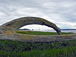
 Low cliffs at the tip of the peninsula between the rivers Wye and Severn, and a tidal island centred on a ruined medieval chapel Rating: ★★★★★ |
 1.3 mile stretch of flat land beside the Severn Estuary, between two road access points, a good location for saltmarsh plants Rating: ★★★★★ |
 Three miles of the Severn Estuary coastline, lined by saltmarsh, including the Pilning Wetlands, a series of artificially-created pools Rating: ★★★★★ |
 Wooded slopes of grey and red mudstone above a narrow beach bordering the River Severn Rating: ★★★★★ |
 Three miles of flat Severn Estuary coastline, mainly saltmarsh with some sand and shingle; good for wildflowers Rating: ★★★★★ |
Somerset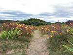 Grassy and sandy dunes stretching over 2 miles along the west Somerset coast, partly occupied by a golf course and partly by a local nature reserve Rating: ★★★★★ |
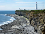
 High, narrow limestone peninsula along the north Somerset coast, lined by cliffs; site of a 19th century fort and several more ancient relics Rating: ★★★★★ |
 Four mile stretch of the coast; limestone cliffs and some pebble beaches, but mostly saltmarsh and grassy fieldss Rating: ★★★★★ |
 Saltmarsh, fields, ruins and a long pebble beach, between two sandstone headlands Rating: ★★★★★ |
 Four mile stretch of the coast, including Kilve Pill and Quantock's Head, with layered, blue lias cliffs above extensive, wave-cut terraces Rating: ★★★★★ |
 Cliffs and pebble beaches along a spectacular, little-visited, five mile section of the north Somerset coast Rating: ★★★★★ |
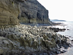
 Five miles of the Somerset coast; rarely-seen beaches and eroded sandstone formations below steep cliffs and extensive ancient woodland Rating: ★★★★★ |
 Low cliffs, eroded rocks, pebble beaches and a lighthouse, along the Bristol Channel coastline between Portishead and Clevedon Rating: ★★★★★ |
 Narrow promontory and elevated headland overlooking the Bristol Channel, lined by stony beaches and eroded rock formations Rating: ★★★★★ |
 Peninsula between Bridgewater Bay and the River Parrett; sand and shingle beaches, mudflats and saltmarsh Rating: ★★★★★ |
 6.5 miles of coastline; complex cliffs and rock formations, giving way to grassland and sand/pebble beaches Rating: ★★★★★ |
 Three mile stretch of the coast, with layered cliffs, pebble banks, wave-cut terraces, sand/mud beaches and a moss-lined waterfall Rating: ★★★★★ |
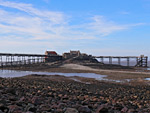 Rocky, cliff-lined beach of pebbles, sand and mud, and a tidal island linked by a derelict pier, on the north side of Weston-super-Mare Rating: ★★★★★ |
Wales
Bridgend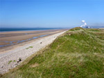 Varied coastal dune habitats, including sand, slacks, grassland, marsh, woodland and beaches, supporting a great range of plants and animals Rating: ★★★★★ |
 Coastal sand dunes near the River Ogmore; grassy near the sea, more overgrown further inland. Home to many wildflower species Rating: ★★★★★ |
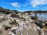 Wave-carved, inter-tidal rocks, all pinkish Mercia mudstone, containing innumerable tidepools and eroded formations Rating: ★★★★★ |
Newport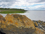 Three mile stretch of the Gwent Levels, including saltmarsh, mudflats, saline lagoons, reedbeds, wet grassland and wet woodland Rating: ★★★★★ |
Swansea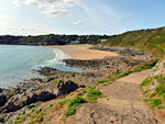 Two sandy beaches lined by eroded cliffs of inclined limestone, linked by a short section of the coast path Rating: ★★★★★ |
 Three miles of limestone coastline; wave-cut terraces and other eroded formations, beneath grassy bluffs and higher cliffs Rating: ★★★★★ |
 Spectacular, lightly-travelled, two mile section of the southern coast; limestone hills sloping down to rocky inlets, sea caves and wave-cut terraces Rating: ★★★★★ |
 Broad sandy beaches separated by a line of limestone cliffs, a tidal island, and grassy sand dunes Rating: ★★★★★ |
 Three miles of the most rugged, inaccessible and least-visited section of the Gower coastline Rating: ★★★★★ |
 Sandy inlet on the Gower Peninsula, bordered by dramatic cliffs, centred on a narrow promontory and crossed by a stream Rating: ★★★★★ |
 Limestone cliffs and bluffs above small pebble/sand beaches and extensive inter-tidal terraces, with many eroded formations Rating: ★★★★★ |
 Sandy beaches, grassy dunes, wetlands and forest, on the remote northwestern corner of the Gower Peninsula Rating: ★★★★★ |
 Tidal island south of Rhossili Bay at the western tip of the Gower Peninsula, surrounded by limestone cliffs and eroded formations Rating: ★★★★★ |
Vale of Glamorgan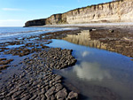 Cliffs, terraces and pebble beaches along the easternmost three mile portion of the Glamorgan Heritage Coast. Includes Limpert Bay, Penry Bay and Summerhouse Point Rating: ★★★★★ |
 Five mile stretch of the coast; long cliffs of thin-layered limestone above terraces and pebble beaches Rating: ★★★★★ |
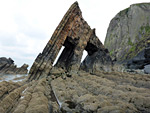
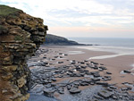 Cliffs, beaches and eroded rock formations along the Glamorgan Heritage Coast near Southerndown, plus gardens, a ruined mansion and a waterfall Rating: ★★★★★ |
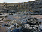 Cliffs, terraces, beaches and rock pools along a three mile stretch of the coast, plus a stream with travertine formations Rating: ★★★★★ |
 Varied, little-visited, four-mile section of the Glamorgan Heritage Coast, with layered, vertical cliffs of blue lias above extensive wave-cut terraces Rating: ★★★★★ |
 Wide sandy beach giving way to sheer limestone cliffs with caves, terraces and other eroded formations Rating: ★★★★★ |
 Wide bay with grey pebbles and muddy terraces, bordered to the west by more photogenic red cliffs and eroded formations Rating: ★★★★★ |
 Headland, layered cliffs, level terraces, sand and pebble beaches, and an undeveloped tidal island Rating: ★★★★★ |